Showing posts with label ARGENTINA. Show all posts

10/05/2022

ARGENTINA


ARGENTINA.

Year of Tourism in the Americas.
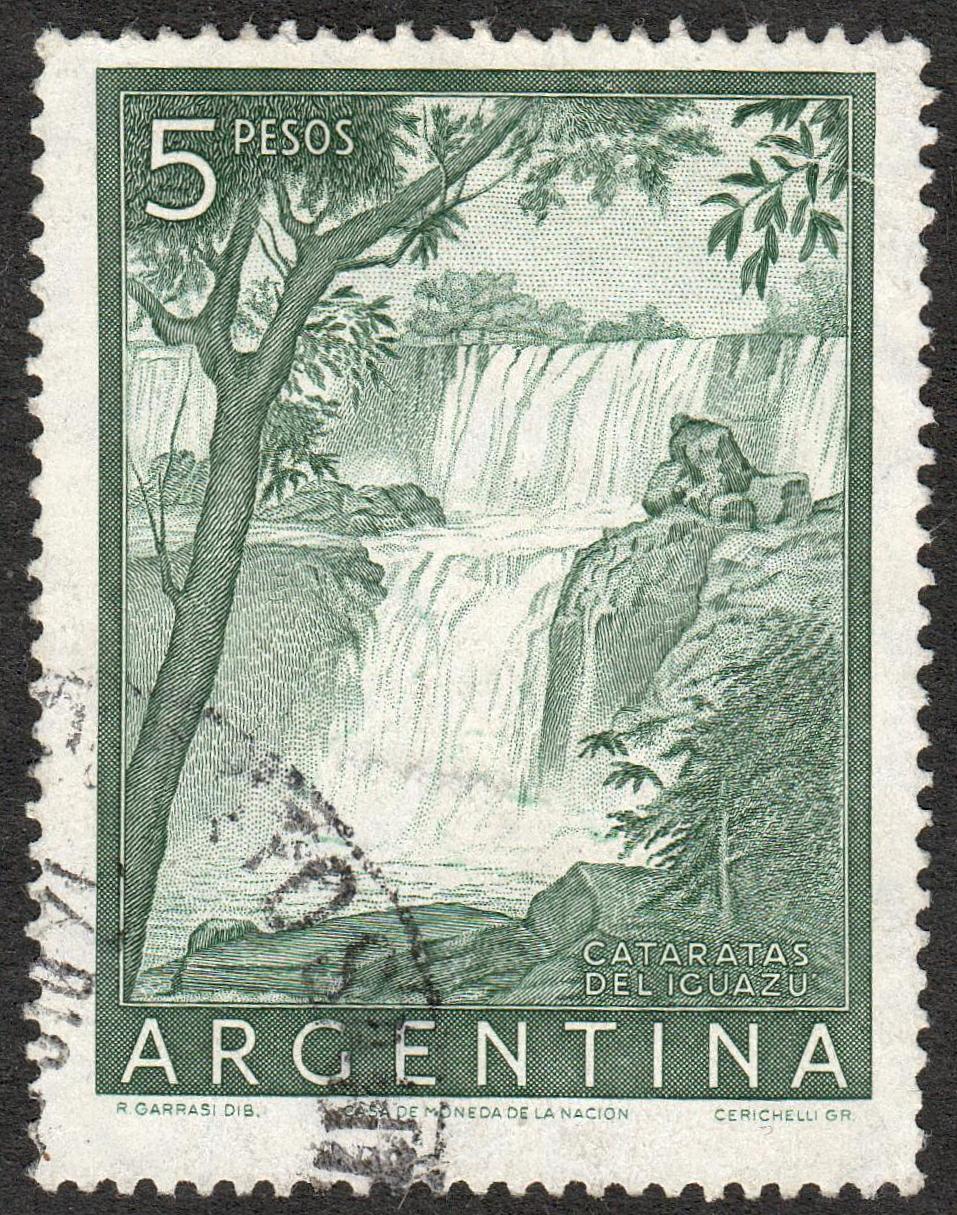
Iguazu Falls.
Stamp issued on 16.12.1972.
Face value: 45 Argentine centavos.
Printing: Offset lithography.
Print: 1,000,000 copies.
Size: 66 x 30 mm.

Catalogs
- Cefiloza No. 1132.
- Götig & Jalil No. 1602.
- Michel No. 1135.
- Scott No. 985.
- StampWorld No. 1159.
- Stanley Gibbons No. 1410.
- Yvert et Tellier No. 935.

Iguazu Falls (in Spanish, Cataratas del Iguazú; in Guarani, Chororõ Yguasu; in Portuguese, Cataratas do Iguaçu), formed by the Iguazu River on the border of the Argentine province of Misiones and the Brazilian state of Paraná, are the largest in the world. Most of the falls (80%) are on the Argentine side, and at its confluence with the San Antonio River, the Iguazu River serves as the border between Argentina and Brazil. The falls have different heights; the largest is 82 m (269 ft). Its average flow is 1,756 m3 per second (62,010 ft3/s). The first European to register the existence of the falls was the Spanish Álvar Núñez Cabeza de Vaca in 1542, who called them “Saltos de Santa María”; However, the first to spot them had been Aleixo García, a castaway from the expedition of Juan Díaz de Solís, in 1524, when he crossed that region in search of the Sierra de la Plata. In 1934 the Argentine government established the Iguazú National Park, which was declared a World Heritage Site by Unesco in 1984.

24/01/2022

ARGENTINA


ARGENTINA.

Argentine Provinces.
Fonck Lake, Río Negro Province.
Third stamp in a set of 4, issued on 08.10.1977.
Face value: 30 Argentine pesos ley.
Printed by Casa de Moneda, Buenos Aires.
Printing: Offset lithography.
Print: 500,000 copies.
Size: 66 x 30 mm.

Catalogs
- Cefiloza No. 1320.
- Götig and Jalil No. 1798.
- Michel No. 1315.
- Scott No. 1154.
- StampWorld No. 1338.
- Stanley Gibbons No. 1572.
- Yvert et Tellier No. 1100.

Lake Fonck, of glacial origin, is located within the Nahuel Huapi National Park, in the department of Bariloche, province of Río Negro, at an altitude of 780 m (2,559 ft). It has an area of 4.82 km2 (1.86 sq mi) and occupies a valley surrounded by the Volcánico, Fonck and Hess mountains; from its shores you can see Mount Tronador (visible on the stamp), located about 15 km (9.32 mi). It belongs to the Manso river basin. It is surrounded by Andean Patagonian forest. It owes its name to the German-Chilean explorer Francisco Fonck, who visited the region at the end of the 19th century.

02/12/2021

ARGENTINA


ARGENTINA.

Argentine Provinces.
Sierra de la Ventana, Buenos Aires Province.
First stamp in a set of 4, issued on 08.10.1977.
Face value: 30 Argentine pesos ley.
Printed by Casa de Moneda, Buenos Aires.
Printing: Offset lithography.
Print: 500,000 copies.
Size: 66 x 30 mm.

Catalogs
- Cefiloza No. 1321.
- Götig and Jalil No. 1799.
- Michel No. 1312.
- Scott No. 1151.
- StampWorld No. 1336.
- Stanley Gibbons No. 1570.
- Yvert et Tellier No. 1101.

The Ventania System belongs to the Southern Sierras of Buenos Aires Province. The mountain range system has a length of 195 km (121.16 mi) from northwest to southwest. Its highest peaks are Cerro Tres Picos, 1,239 m (4,065 ft), Destierro Primero, 1,172 m (3,845 ft), Cerro Ventana, 1,134 m (3,720 ft), Napostá Grande, 1,108 m (3,635 ft), Cura Malal Grande, 1,037 m (3,402 ft), and Cura Malal Chico, 1,000 m (3,281 ft). British naturalist Charles Darwin described his ascent of the Sierra de la Ventana range in the sixth chapter of his work The Voyage of the Beagle.

17/10/2021

POLAND


POLAND / POLSKA.

100th Anniversary of Polish Settlement in Argentina.
Map of South America with Argentina highlighted.
Stamp issued on 06.06.1997.
Face value: 1.40 Polish 
złotych.
Design: Andrzej Radziejowski.
Printed by PWPW (Polska Wytwórnia Papierów Wartościowych), Warszawa.
Printing: Offset lithography.
Print: 700,000 copies.

Catalogs
- AFA No. 3553.
- Fischer No. 3512.
- Michel No. 3660.
- Scott No. 3357.
- StampWorld No. 3666.
- Stanley Gibbons No. 3695.
- Yvert et Tellier No. 3441.

Polish immigration in Argentina began at the end of the 19th century. Poland was the fourth largest net contributor of European immigrants after Spain, Italy and Germany. The first known Polish immigrants were a group of 14 families (120 people) from Galicia, a territory of the Austro-Hungarian Empire divided today between Poland and Ukraine, who were heading to the United States and who, due to lack of documentation, had to choose between returning to their places of origin or undertake another destination: the Argentine consul in Trieste offered them lands to colonize in their country and they accepted. They arrived in La Plata in 1897. The governor of the National Territory of Misiones, Juan José Lanusse, accepted to welcome them. Today it is estimated that more than a million Argentines have Polish ancestry.

-
Thanks to Sylvester Dulewski for his contribution (https://birdsposta.blogspot.com/).

12/07/2021

ARGENTINA


ARGENTINA.

Tourism.
Valle de la Luna or Ischigualasto Park (San Juan).
First stamp in a set of 3, issued on 10.01.1977 [09.1977?].
Face value: 300 Argentine pesos ley.
Printed by Casa de Moneda, Buenos Aires.
Printing: Offset lithography.
Size: 34.5 x 45 mm.

Catalogs
- Cefiloza No. 1293.
- Götig & Jalil No. 1761-
- Michel No. 1288.
- Scott No. 1108.
- StampWorld No. 1312.
- Stanley Gibbons No. 1474.
- Yvert et Tellier No. 1075.

The Valle de la Luna (Moon Valley) or Ischigualasto Provincial Park is located in the northeast of the Argentine province of San Juan and borders the province of La Rioja to the north. Its altitude with respect to sea level varies between 1,200 m (3,940 ft) and 1,800 m (5,900 ft). It is an area of 2,754 km2 (1,063 sq mi), of great scientific importance, since it protects an important paleontological reserve. It is the only place in the world where the entire Triassic period can be seen uncovered and perfectly differentiated in a complete and orderly manner. The geological formations at this site are estimated to be between 200 and 250 million years old. The place is characterized by having little vegetation and the most varied range of colors in its soils. Being a preserved place (declared a Natural Heritage of Humanity by UNESCO, on November 29, 2000), visits are restricted and can only be done guided. Due to the large deposits rich in fossils in the Ischigualasto area, this place has attracted the interest of geologists and paleontologists since the 1930s. One of the most important pieces found in the area is the Eoraptor lunensis, a very primitive dinosaur discovered in 1991.

-
Thanks to Óscar Valencia for his contribution.

16/04/2021

URUGUAY


URUGUAY.

Salto Grande Dam (and coats of arms of Uruguay and Argentina).
Stamp issued on 19.06.1979.
Face value: 2 Uruguayan new pesos.
Design; Ángel Medina Medina (1914-1980).
Printed by Imprenta Nacional, Montevideo.
Printing: Offset lithography.
Print: 50,000 copies.

Catalogs
- Michel No. 1547.
- Scott No. 1043.
- StampWorld No. 1546.
- Stanley Gibbons No. 1710.
- Yvert et Tellier No. 1025

The Salto Grande Dam (officially, in Spanish: Central Hidroeléctrica Binacional Salto Grande) is a large hydroelectric dam on the Uruguay River, located between Salto, Uruguay, and Concordia, Argentina; it is therefore shared by the two countries. Construction of the dam began on April 1, 1974 and was completed on June 21, 1979. The reservoir has a total area of 783 km2 (302 sq mi), while its maximum dimensions are 140 by 9 km (87.0 mi × 5.6 mi). The levee is 65 m (213 ft) high and 3,000 m (9,800 ft) long.

15/04/2021

ARGENTINA


ARGENTINA.

Definitive stamps.
El Nihuil Dam.
Eighth stamp in a set on 12, issued on 04.05.1956.
Face value: 3 Argentine peso moneda nacional.
Design: Renato Garrasi (1915-1990).
Engraving: Volumnio Cerichelli.
Printed by Casa de Moneda de la Nación, Buenos Aires.
Printing: Recess.
Size: 37 x 26.

Catalogs
- Götig and Jalil No. 1050.
- Gz (Celogiloza) No. 720.
- Michel No. 627.
- Scott No. 638.
- StampWorld No. 649.
- Stanley Gibbons No. 874.
- Yvert et Tellier No. 548A.

The El Nihuil dam, in the course of the Atuel river (a tributary of the Desaguadero river), in the south of the province of Mendoza, is made of simple concrete and a triangular profile, and is 315 m (1,033.4 ft) long. Its construction began in 1942 and was officially inaugurated on January 11, 1948. It forms the reservoir of the same name, 1,325 m (4,347 ft) above sea level. The 9,600 ha reservoir, inaugurated in 1947, serves both for irrigation and electricity generation, and also for tourist, recreational and sports activities.

-
Thanks to Dragan Buškulić for his contribution (https://worldofstamp2.wordpress.com/).

03/04/2021

ARGENTINA


ARGENTINA.

International Fair of Aconcagua, Mendoza, 1990.
Laguna de Horcones and Mount Aconcagua.
Stamps issued on 03.03.1990.
Face value: 500 and 500 Argentine australes.
Design: Gabriela Ojeda.
Printed by Casa de Moneda, Buenos Aires.
Printing: Offset lithography.
Print: 208,000 copies.
Size: 68 x 45 mm.

Catalogs
- Götig and Jalil No. 2480-2481.
- Gz (Gefiloza) No. 1996-1997.
- Michel No. 2012-2013.
- Scott No. 1677.
- StampWorld No. 2038-2039.
- Stanley Gibbons No. 2192-2193.
- Yvert et Tellier No. 1713-1714.

Aconcagua is a mountain in the Cordillera Principal of the Andes, in the Argentine province of Mendoza, 15 km (9 mi) from the border with Chile. It is the highest mountain in America, with an elevation of 6,961 m (22,838 ft). It is bounded by the Valle de las Vacas to the north and east and the Valle de los Horcones Inferior to the west and south. It was created by the subduction of the Nazca plate under the South American plate, and from the Upper Cretaceous to the Miocene it was an active volcano. On its slopes are several glaciers. The mountain and its surroundings are part of the Aconcagua Provincial Park.
The Europeans' first attempt to reach its summit was made in 1883 by a team led by the German geologist and explorer Paul Güssfeldt, who reached only an altitude of 6,500 m (21,300 ft). The first recorded ascent is that of an expedition led by Edward FitzGerald between 1896 and 1897, which despite eight attempts failed to reach the top, but the (Swiss) guide of the expedition, Matthias Zurbriggen, reached the summit on 14 January 1897.
For the Incas, Aconcagua and other mountains of the Andes were sacred mountains, considered "living mountains" (Apus, which means "lord" or "lady"), and on their slopes they built places of worship where they made sacrifices.

16/03/2021

ARGENTINA


ARGENTINA.

Taking of possession of the Malvinas Islands by Argentina in 1820.
Argentine frigate "Heroína" and small map of Malvinas (Falkland) Islands.
Stamp issued on 24.04.1976.
Face value: 6 Argentine peso ley.
Design: From a painting of Emilio Biggeri (1907-1977).
Printed by Casa de Moneda, Buenos Aires.
Printing: Offset lithography.
Print: 1,000,000 copies.
Size: 29 x 67 mm.

Catalogues
- Götig and Jalil No. 1711.
- Gz (Cefiloza) No. 1263.
- Michel No. 1268.
- Scott No. 1131.
- StampWorld No. 1292.
- Stanley Gibbons No. 1514.
- Yvert et Tellier No. 1050.

On November 6, 1820, the American colonel at the service of the United Provinces of the River Plate, David Jewett, commanding the frigate Heroína, carried out in Puerto Soledad (now Port Louis) the takeover of the Malvinas Islands (now British Falkland Islands) and raised the Argentine flag on behalf of the Government of those United Provinces, which was the name of Argentina used at that time. The islands remained under the possession of the United Provinces until the British occupation in January 1833. The archipelago was sighted for the first time in 1520 by Esteban Gómez from the San Antonio ship of the Spanish expedition of Ferdinand Magellan. British historiography maintains, however, that the islands were discovered by John Davis in 1592, a disputed claim.

04/03/2021

ARGENTINA


ARGENTINA.

Tourism.
Purmamarca (Jujuy). Cerro de los Siete Colores.
Stamp issued on 01.11.1988.
Face value: 3 Argentine australes.
Design: N. Martín.
Printing by Casa de Moneda, Buenos Aires.
Printing: Offset lithography.
Size: 38.5 x 27 mm.

Catalogues
- Cefiloza( (Gz) No. 1931.
- Götig and Jalil No. 2387.
- Michel No. 1942.
- Scott No. 1635A.
- StampWorld No. 1968.
- Stanley Gibbons No. 2090a.
- Yvert et Tellier No. 1647.

Purmamarca is an andine town in the department of Tumbaya, in the Argentine province of Jujuy. The most characteristic of the landscape of the place is the Cerro de los Siete Colores (the Hill of Seven Colors), a geological curiosity that originated about 75 million years ago. It is made up of marine, lake and river sediments that were deposited in the area for centuries. The most visible colors are pink, whitish, browns, purples, red, green and mustard yellow, according to the minerals that make up the soil. In 2003 the hill was declared by UNESCO Cultural Heritage of Humanity for its cultural value.

19/02/2021

ARGENTINA


ARGENTINA.

Definitive stamps. Iguazu Falls.
Stamp issued on 01.12.1955.
Face value: Argentine pesos moneda nacional.
Design: Renato Garrasi (Garassi?, 1915-1990?).
Engraving: Volumnio Cerichelli.
Printing: Recess.
Printed by Casa de Moneda de la Nación, Buenos Aires.
Size: 44 x 34 mm.

Catalogues
- Cefiloza No. 722.
- Götig and Jalil No. 1052.
- Michel No. 628.
- Scott No. 639a.
- StampWorld No. 650.
- Stanley Gibbons No. 875a.
- Yvert et Tellier No. 549.

Iguazu Falls (in Spanish, Cataratas del Iguazú; in Guarani, Chororõ Yguasu; in Portuguese, Cataratas do Iguaçu), formed by the Iguazu River on the border of the Argentine province of Misiones and the Brazilian state of Paraná, are the largest in the world. Most of the falls (80%) are on the Argentine side, and at its confluence with the San Antonio River, the Iguazu River serves as the border between Argentina and Brazil. The falls have different heights; the largest is 82 m (269 ft). Its average flow is 1,756 m3 per second (62,010 ft3/s). The first European to register the existence of the falls was the Spanish Álvar Núñez Cabeza de Vaca in 1542, who called them “Saltos de Santa María”; However, the first to spot them had been Aleixo García, a castaway from the expedition of Juan Díaz de Solís, in 1524, when he crossed that region in search of the Sierra de la Plata. In 1934 the Argentine government established the Iguazú National Park, which was declared a World Heritage Site by Unesco in 1984.

09/02/2021

ARGENTINA


ARGENTINA.

Definitive stamps.
Inca Bridge (Puente del Inca), Mendoza.
Fourth stamp in a set of 7, issued on 30.06.1971.
Face value: 10 cents of Argentinian peso.
Printing: Offset lithography.
Printed by Casa de Moneda de la Nación, Buenos Aires.
Size: 27 x 37 mm.

Catalogues
- Gz (Argentina) No. 1083.
- Michel No. 1097.
- Scott No. 929.
- StampWorld No. 1121.
- Stanley Gibbons No. 1305.
- Yvert et Tellier No. 886.

The Inca Bridge (in Spanish, Puente del Inca), is a natural arch located in Mendoza Province at 2,740 m (8,990 ft) above sea level, that forms a bridge suspended at 19.2 m (63 ft) over the Las Cuevas River, a tributary of the Mendoza River. It is 53.4 m (175.19 ft) long, 27.6 m (90.55 ft) wide, and 10.2 m2 (109.79 sq ft) thick. Both glaciers and hot springs participated in the formation of the arch. In March 1835, Charles Darwin visited the site and made some drawings of the bridge with large stalactites. At the beginning of the 20th century there was a large thermal complex and a monastery that used thermal waters to cure certain diseases. The arch is part of the Andean Qhapaqñan road system, declared a World Heritage Site by UNESCO. By a 1992 decree of the Argentine government, the intangible zone of Puente del Inca was regulated, defining an area of high restriction and another of attenuated restriction.

09/01/2021

ARGENTINA


ARGENTINA.

International Geophysical Year.
Stylized map of the Antarctica.
Stamp issued on 12.07.1958.
Face value: 40 cents of Argentinian peso.
Printing: Offset lithography.
Printed by Casa de Moneda de la Nación, Buenos Aires.
Print: 5,000,000 copies.
Size: 37 x 26 mm.

Catalogues
- Cefiloza (Gz) No. 760.
- Götic & Jalil No. 1108.
- Michel No. 684.
- Scott No. 677.
- StampWorld No. 709.
- Stanley Gibbons No. 931.
- Yvert et Tellier No. 591.

The International Geophysical Year (IGY) was proposed in 1952 by the International Council of Scientific Unions on the model of the International Polar Years of 1882-83 and 1932-33. It was intended to use various technologies inherited from the Second World War for peaceful purposes, deciding to concentrate efforts on Antarctica, little known at that time. The IGY lasted from July 1, 1957 to December 31, 1958 and was a unique effort because of its scope in the history of science. More than 30,000 scientists and technicians from 66 countries cooperated in a series of observations about Earth and its cosmic surroundings. Five of the eleven scientific branches studied were specifically dedicated to this type of research: solar activity, cosmic rays, geomagnetism, northern lights and ionospheric physics.

28/12/2020

ARGENTINA


ARGENTINA.

Rocket launch from Argentine Antarctica.
Stylized map of the Antarctic territory claimed by Argentina, and "Centauro" rocket.
Airmail stamp issued on 19.02.1966.
Face value: 27.50 Argentine pesos.
Printed by Casa de Moneda, Buenos Aires.
Print: 1,000,000 copies.
Size: 40 x 35 mm.

Catalogues
- Michel No. 858. (?)
- Scott No. C105.
- StampWorld No. 923.
- Yvert et Tellier No. PA112.

Argentina claims the sector of Antarctica between meridians 74°W and 25°W, parallel 60°S and the south pole as one of its geographical regions and as an integral part of its territory (administratively, for Argentina the area is part of the province of Tierra del Fuego, Antarctica and the South Atlantic Islands). This sector is partially overlapped, between the South Pole and the Antarctic peninsula (Tierra de San Martín in the official Argentine cartography), with the eastern area of the sector claimed by Chile (Chilean Antarctic Territory) and totally with the sector claimed by the United Kingdom (British Antarctic Territory). Argentine Antarctic claims are based on historical and geological considerations, of continued Argentine human presence since 1904, and of proximity to continental Argentina. The exercise of Argentine sovereignty over Argentine Antarctica becomes effective in all aspects that are not limited by the signing of the Antarctic Treaty in 1959. The estimated area of the so-called Argentine Antarctica is 1,461,597 km², of which 965,314 km² correspond to the mainland.

24/12/2020

ARGENTINA


ARGENTINA.

50th anniversary of the Pan American Union, 1890-1940.
Stylized map of all American continent.
Stamp issued on 14.04.1940.
Face value: 15 centavos of Argentine peso moneda nacional.
Engraving by Oppeos.

Catalogues
- GJ No. 839.
- Scott No. 473.
- StampWorld No. 464.
- Yvert et Tellier No. 412.

The Pan American Union (Unión Panamericana) was founded on April 14, 1890 as the Commercial Office of the American Republics, and from 1902 it was also known as the International Office of the American Republics. On April 30, 1948, through the Charter of Bogotá, it became the Organization of American States. Its founding functions were to compile and distribute commercial information and customs tariffs, regulations, treaties, and statistics.

10/12/2020

ARGENTINA


ARGENTINA.

Simplified map of Argentina in South America (including the islands Malvinas / Falkland).
Sixth stamp in a set of 10. Issued in 03.1945.
Face value: 1 Argentinian peso.
Size: 38 x 25 mm.

Catalogues
- StampWorld No. 533.
- Stanley Gibbons No. 760.
- Yvert et Tellier No. 380.