30/06/2021

ALBANIA


ALBANIA / SHQIPERIA.

Tourism.
Mount Arapi in Theth Valley.
Third stamp in a set of 6, issued in March 1965.
Face value: 3 Albanian lek.
Printing: Offset lithography.
Print: 80,000 copies.

Catalogs
- Michel No. 928.
- Scott No. 803.
- StampWorld No. 937.
- Stanley Gibbons No. 889.
- Yvert et Tellier No. 754.

Mount Arapi (Albanian: Maja e Arapit ot Maja e Harapit) is located in the north of Albania, near the border with Montenegro. It is 2,217 m (7,274 ft) high, with an 800 m (2,600 ft) south wall. It is one of the landmarks of Theth Valley, on the edge of the Theth National Park (Albanian: Parku Kombëtar i Thethit), with an area of 26.3 km2 (10.15 sq mi), established in 1966 to protect various ecosystems and the biodiversity and cultural and historical heritage of the region. The park is centered on the Albanian Alps (a subrange of the Dinaric Alps), encompassing the larger portion of Shala Valley. In 2017, Theth has been further declared a Protected Historic Center.

NEPAL


NEPAL / नेपाल.

Rara Lake.
Third stamp in a set of 3, issued on 11.06.1970.
Face value: 1 Nepalese rupee.
Printing: Photogravure.

Catalogs
- Michel No. 251.
- Scott No. 236.
- StampWorld No. 247.
- Stanley Gibbons No. 252.
- Yvert et Tellier No. 221.

The Rara (Nepali: राराताल) is the largest and deepest freshwater lake in Nepal. It is located in the Rara National Park, in the Himalayas, on the border of the Jumla and Mugu districts, in the northwest of the country, at an altitude of 2,990 m (9,810 ft) above sea level. Its surface area is 10.8 km2 (4.2 sq mi) and its maximum depth is 167 m (548 ft). The Níjar River feeds the lake, which empties into the Karnali River, one of the main tributaries of the Ganges. In September 2007, the lake and adjacent areas were protected by the Ramsar Convention. There are more than 250 species of birds and many mammals in the area, including the Asian black bear (Ursus thibetanus) and the red panda (Ailurus fulgens).

29/06/2021

SENEGAL


SENEGAL / SÉNÉGAL - SENEGAAL (French colony).

Definitive stamps.
Faidherbe Bridge over the Senegal River.
Firsy stamp in a set of 12, issued on 15.12.1935.
Face value: 1 cent of French franc.
Printed by Institut de Gravure, Paris.
Printing: Recess.
Size: 40 x 26 mm.

Catalogs
- Michel No. 118.
- Scott No. 142.
- StampWorld No. 124.
- Stanley Gibbons No. 139.
- Yvert et Tellier No. 114.

The Faidherbe Bridge over the Senegal River connects the island of the city of Saint-Louis with the African continent. The metal bridge, opened on July 14, 1897, is 507.35 m (1,664.5 ft) long and 10.5 m (34 ft) wide. It has eight spans, of which the five longest are 78.26 m (256.8 ft). Until the 19th century, access to the island was through boats. After the introduction of a ferry that could carry 150 passengers, the French colonial administrator Louis Faidherbe considered that the system was insufficient and proposed the construction of this road bridge.

COMOROS


COMOROS / UNION DES COMORES - UDZIMA WA KOMORI.

Eruption of Karthala volcano (September 1972).
Airmail stamp issued on 16.07.1973.
Face value: 120 French African CFA francs.
Design and engraving: Georges Bétemps (1921-1992).
Printing: Photogravure.

Catalogs
- Michel No. 159.
- Scott No. C54.
- StampWorld No. 140.
- Stanley Gibbons No. 140.
- Yvert et Tellier No. PA 54.

Karthala (Karatala, Kartala or Kartola, in Arabic القرطالة) is a shield volcano 30 km (18.64 mi) long and 15 km (9.32 mi) wide located on the island of Grande Comore. It culminates at 2,361 m (7,746 ft) above sea level. At its top there is a caldera 3 km (1.86 mi) wide by 4 km (2.48 mi) long. It is a relatively active volcano, with twenty Hawaiian-type eruptions during the 19th and 20th centuries, which have formed lava flows that reach the sea in some cases. In one of the craters it was formed a lava lake. Although there are data of eruptions in 12th century, the first that is documented took place in 1808; the most violent eruptions, causing human casualties, were those of 1884, 1904, 1977 and the end of 2005. On November 12, 2006, Karthala was recognized as a Ramsar site due to the diversity of the wetlands surrounding the volcano. The first recorded ascension was that of Doctor Kresten in 1863.

27/06/2021

LATVIA


LATVIA / LATVIJA.

Nature Reserves.
Teiči Nature Reserve.
Second stamp in a set of 2, issued on 30.04.1998.
Face value: 30 Latvian santims.
Printing; Offset lithography.
Print: 300,000 copies.
Size: 36 x 28.5 mm.

Catalogs
- AFA No. 481.
- Michel No. 478.
- Scott No. 465.
- StampWorld No. 443.
- Stanley Gibbons No. 490.
- Yvert et Tellier No. 442.

Teiči Nature Reserve (Latvian: Teiču dabas rezervāts) is a nature reserve situated in eastern Latvia, spread across Madona, Varakļāni and Krustpils municipalities. The nature reserve was created in 1982. Its purpose is to protect the eponymous bog, one of the largest in Latvia and the Baltic states. The nature reserve covers an area of 197.80 km2 (76.37 sq mi), of which 136.80 km2 (52.82 sq mi) is composed of Teiči bog. In this wet area, veritable little lakes have formed in places and there are in total 18 such lakes within the area, but in other places raised patches of firmer ground form little islands in the bog. The bogs have been designated as a protected Ramsar site since July 25, 1995. Since 2004, it is part of the EU-wide Natura 2000-network.

26/06/2021

BRAZIL


BRAZIL / BRASIL.

Tourism.
Guarapari Beach, Espírito Santo.
First stamp in a set of 3, issued on 19.12.1975.
Face value: 0.70 Brazilian cruzeiros.
Printing: Offset lithography.
Print: 1,500,000 copies.
Size: 41 x 29 mm.

Catalogs
- Michel No. 1514.
- RHM No. C916.
- Scott No. 1418.
- StampWorld No. 1531.
- Stanley Gibbons No. 1565.
- Yvert et Tellier No. 1176.

Guarapari is a municipality in the Brazilian state of Espírito Santo. Its population, in 2018, was 122,982 inhabitants. The city, as well as the entire central state region, has several granite outcrops and many inlets, protected bays and more than thirty beaches, famous for their high level of natural radioactivity.

SINGAPORE


SINGAPORE / SINGAPURA - 新加坡共和国

Old maps.
Map of Singapore island as part of the Malay Peninsula.
Third stamp in a set of 4, issued on 13.03.1996.
Face value: 1 Singapore dollar.
Printing: Offset lithography.

Catalogs
- Michel No. 793.
- Scott No. 749.
- StampWorld No. 811.
- Stanley Gibbons No. 830.

Map of undetermined date.

HUNGARY


HUNGARY / MAGYARORSZÁG.

International Congress of Esperanto Railways in Budapest.
Simplified map of Europe.
Stamp issued on 05.05.1962.
Face value: 1 Hungarian forint.
Design: Ferenc Bokros (1891-1974).
Printing: Photogravure.
Print: 5,500,000 copies.
Size: 31 x 36 mm.

Catalogs
- AFA No. 1783.
- Michel No. 1819A.
- Philatelia Hungarica No. 1924.
- Scott No. 1436.
- StampWorld No. 1842.
- Stanley Gibbons No. 1795.
- Yvert et Tellier No. 1494.

Esperanto, an international planned language conceived in the second half of the 19th century by the Polish ophthalmologist Ludwik Łazarz Zamenhof, who laid out its foundations in 1887, spread rapidly throughout Europe and the world, and on August 9, 1905 the so-called Declaration of Boulogne it unofficially established it as a universal alternative language. Hungary was one of the first countries to welcome this language, and already in 1902 the Association of Hungarian Esperantists (Hungaria Esperanto-Asocio; Magyar Eszperantisták Egylete) was created, which later had different names; when the congress commemorated by this stamp was held in 1962, the Hungarian Esperanto Association (Magyar Eszperantó Szövetség, 1960-1991) was in force.

25/06/2021

AUSTRALIA


AUSTRALIA.

Panorama of Australia.
The Pinnacles Desert.
First stamp in a set of 4, issued on 17.10.1988.
Face value: 39 cents of Australian dollar.
Printing: Offset lithography.
Size: 35 x 35 mm.

Catalogs
- Michel No. 1131.
- Scott No. 1098.
- Seven Seas Stamps No. 1174.
- StampWorld No. 1133.
- Stanley Gibbons No. 1161.
- Yvert et Tellier No. 1099.

The Pinnacles are limestone formations within Nambung National Park, near the town of Cervantes, Western Australia. The area contains thousands of weathered limestone pillars. Some of the tallest pinnacles reach heights of up to 3.5 m (11.48 ft) above the yellow sand base. The different types of formations include ones which are much taller than they are wide and resemble columns (suggesting the name of Pinnacles) while others are only a meter or so in height and width resembling short tombstones. A cross-bedding structure can be observed in many pinnacles where the angle of deposited sand changed suddenly due to changes in prevailing winds during formation of the limestone beds. The raw material for the limestone of the Pinnacles came from seashells in an earlier era that was rich in marine life. These shells were broken down into lime-rich sands that were blown inland to form high mobile dunes.

-
Thanks to Óscar Valencia for his contribution.

24/06/2021

NORWAY


NORWAY / NORGE - NOREG.

Centennial of the National Tourism Association.
Glittertind peak in Jotunheimen National Park.
Third stamp in a set of 3, issued on 22.01.1968.
Face value: 90 Norwegian øre.
Printing: Recess.
Print: 2,049,500 copies.
Size: 36 x 24 mm.

Catalogs
- AFA No. 576.
- Michel No. 563.
- Norgeskatalogen No. 601.
- Scott No. 512.
- StampWorld No. 579.
- Stanley Gibbons No. 612.
- Yvert et Tellier No. 517.

Glittertind (official form on maps: Glittertinden) is the second highest mountain in the Scandinavian Alps, at 2,465 m (8,087 ft) above sea level, including the glacier at its peak; without the glacier, it is 2,452 m (8,045 ft). It is in the municipality of Lom (Innlandet county), in the Jotunheimen National Park. Its summit was first reached in 1841 by Harald Nicolai Storm Wergeland and Hans Sletten. The Glittertind takes its name from the neighboring Glitra River to which the ending tind which means ‘peak’ has been added.

UNITED KINGDOM, Scotland


UNITED KINGDOM. Scotland.

Landscapes of Scotland.
Loch Assynt, Sutherland.
Value: 2nd class (no face value).
Printed by De La Rue.
Printing: Photogravure.
Size: 35 x 35 mm.

Catalogs
- AFA No. 2332.
- Michel No. 2140.
- Scott No. 2141.
- StampWorld No. 2129.
- Stanley Gibbons No. 2385.
- Yvert et Tellier No. 2462.

Loch Assynt (Scottish Gaelic: Loch Asaint) is a freshwater lake in Sutherland, 8 kilometres (5 mi) of Lochinver. It discharges into the sea at Loch Inver, via the river Inver. The loch is 9.65 km (6 mi) long, and about 1.5 km (1 mi) in maximum breadth. The total area is approximately 8 km2 (3,09 sq mi) and its drainage basin is over 111 km2 (43 sq mi). The total volume of the loch is approximately 250 m3 (9 billion cubic feet) and the maximum depth is 86 m (282 ft). The elevation of the loch's surface above sea level varies with the levels of rainfall but has been measured as 65.55 m (215 ft). There is excellent fishing for trout, sea-trout, and salmon. Ardvreck Castle occupies a promontory on the north shore.

23/06/2021

SPANISH SAHARA


SPANISH SAHARA / SAHARA ESPAÑOL (now Western Sahara, occupied by Morocco).

Pro-Children.
Dunes in the Sahara Desert.
First stamp in a set of 2, issued on 01.06.1973.
Face value: 2 Spanish pesetas.
Printed by F.N.M.T. (Fábrica Nacional de Moneda y Timbre), Madrid.
Printing: Photogravure.
Print: 800,000 copies.
Size: 40.9 x 28.8 mm.

Catalogs
- Edifil
 No. 310.
- Michel No. 341.
- Scott No. 226.
- StampWorld No. 334.
- Stanley Gibbons No. 307.
- Yvert et Tellier No. 295.

The territory of Western Sahara was gradually colonized by Spain since 1860. The first area occupied was the Río de Oro (ادي الذهب), to the south, where in 1884 the city of Villa Cisneros (now Dakhla [الداخلة]) was founded, to which later La Güera (الكويرة‎) and Tiris (part of the Adrar territory, ولاية آدرار, which currently belongs to Mauritania) were annexed. In 1912 the annexation of Saguía el Hamra (الساقية الحمراء) region was agreed with France, where in 1938 the city of El Aaiún (العيون) was founded, which would later become the capital of the entire colony of the Spanish Sahara (الصحراء الإسبانية), relegating Villa Cisneros. The total area of ​​the colony, mostly desert, was about 280,000 km². Its definitive limits were established in the Cintra agreements (April 2, 1958).
In 1968, the Advanced Organization for the Liberation of Saguia el Hamra and Río de Oro, known simply as the Liberation Movement, was founded in the city of Smara (السمارة), which was formally constituted on December 11, 1969 with the aim of achieving the independence from Western Sahara and was outlawed by the Spanish authorities. Later, on May 10, 1973, the Polisario Front (جبهة البوليساريو) was born in Zouérate (الزويرات, Mauritania), ready to fight for independence. Morocco and Mauritania had ambitions to seize the colony, and finally on November 6, 1975 King Hassan II of Morocco organized the so-called Green March, which crossed the internationally recognized border of the Spanish Sahara (which by then had already become a semi-metropolitan province of Spain) to the north. On February 26, 1976, Spain abandoned the territory, after which the Polisario Front proclaimed the Sahrawi Arab Democratic Republic (SADR) and launched a war of liberation of the territory, which would finally be annexed to Morocco despite the reluctance of the international community and the United Nations.

MACAU


MACAU / 澳門

75th Anniversary of the first Portugal-Macau flight.
Map with the flight path.
Minisheet issued on 19.04.1999.
Face value: 6 (3 + 3) Macanese pataca.
Design: Luiz Duran and Acácio Santos.
Printing: Offset lithography.
Print: 1,250,000 copies.
Size: 137 x 104 mm.

Catalogs
- Afinsa-Mundifil No. BL67.
- Michel No. BL65.
- StampWorld No. 1008-1009.
- Stanley Gibbons No. MS1095.
- Yvert et Tellier No. 

On April 2, 1924, the Portuguese aviators José Manuel Sarmento de Beires (1892-1974) and António Jacinto da Silva Brito Pais (1884-1934), left Vila Nova de Milfontes, at the mouth of the Mira river. After a very convulsive journey, they reached the outskirts of the Chinese city of Guangzhou on June 23, after traveling 16,380 kilometers with several stopovers and using two planes, the Pátria and the Pátria II. His feat, however, was silenced after the proclamation of Estado Novo in Portugal after the military coup of May 28, 1926, which both pilots opposed. On December 20, 1999, a few months after the issuance of these stamps, the Portuguese colony of Macao came under the sovereignty of the People's Republic of China.

21/06/2021

AUSTRIA


AUSTRIA / ÖSTERREICH.

Mount Martinswand, near Zirl (Tirol).
Stamp issued on 13.06.1986.
Face value: 5 Austrian shilling.
Design: Adalbert Pilch (1917-2004).
Engraving: Rudolf Toth (1918-2009).
Printing: Photogravure and recess.
Print: 3,350,000 copies.
Size: 42 x 36 mm.

Catalogs
- AFA No. 1743.
- ABK No, 1882.
- Michel No. 1851.
- Scott No. 1349.
- StampWorld No. 1896.
- Stanley Gibbons No. 2096.
- Unificato No. 1680.
- Yvert et Tellier No. 1680.

Mount Martinswand, at an altitude of 1,113 m (3,652 ft), is located in the municipality of Zirl. It belongs to the Solstein Group of the Karwendel mountain range, which is part of the Alps, in North Tyrol. It is made up of chemically very pure limestone, which tends to become karst, hiding many cavities and caves. According to the records, the first climbers to reach the top, in 1932, were Hias Auckenthaler and Hans Frenademetz. Today many people practice the sport of climbing here.

20/06/2021

YUGOSLAVIA (Croatia)


YUGOSLAVIA (Croatia) / JUGOSLAVIJA (Hrvatska).

Airmail definitive stamps.
Waterfalls in the Plitvice Lakes National Park.
Second stamp in a set of 9, issued on 16.06.1951.
Face value: 2 Yugoslav dinar.
Design: Janez Trpin (1908-1973).
Engraving: Kocmut.
Printing: Recess.
Size: 39 x 24 mm.

Catalogs
- AFA No. 636.
- Michel No. 645A.
- Scott No. C35.
- StampWorld No. 677.
- Stanley Gibbons No. 676.
- Yvert et Tellier No. PA 33.

Plitvice Lakes National Park (Croatian: Nacionalni park Plitvička jezera), founded in 1949, in 1979 was inscribed on the UNESCO World Heritage list, due to its outstanding and picturesque series of tufa lakes connected by waterfalls. The protected area extends over 296.85 km2 (114.61sq mi), and is located in the mountainous karst area of central Croatia, at the border to Bosnia and Herzegovina; a 90% is part of Lika-Senj County, and the remaining 10% is part of Karlovac County. The highest waterfall is the Large Waterfall (Veliki slap), 78 m (256 ft) high.

-
Thanks to Dragan Buškulić for his contribution (https://worldofstamp2.wordpress.com/).

NEW ZEALAND


NEW ZEALAND.

Rock formations.
Organ Pipes in Mount Cargill.
Third stamp in a set of 6, issued on 17.06.1991.
Face value: 80 cents of New Zealand dollar.
Printing: Offset lithograpgy.
Size: 35 x 29.5 mm.

Catalogs
- Michel No. 1178.
- Scott No. 1040.
- StampWorld No. 1203.
- Stanley Gibbons No. 1616.
- Yvert et Tellier No. 1122.

Organ Pipes is a formation of columnar jointed basalt located in Mount Cargill (Māori: Kapukataumahaka), a volcanic outcrop which dominates the skyline of northern Dunedin, in New Zealand’s province of Otago. This formation dates back more than ten million years, and is the product of the eruptions of the extinct Dunedin Volcano.

19/06/2021

POLAND


POLAND / POLSKA.

Mountains and plants in Tatra National Park.
Mount Krzesanica.
Second stamp in a set of 6, issued on 05.09.1996.
Face value: 40 Polish grosz.
Design: Jacek Brodowski.
Printed by PWPW (Polska Wytwórnia Papierów Wartościowych), Warszawa.
Printing: Offset lithography.
Print: 1,000,000 copies.
Size: 43 x 31 mm.

Catalogs
- AFA No. 3512.
- Fischer No. 3471.
- Michel No. 3619.
- Scott No. 3314.
- StampWorld No. 3625.
- Stanley Gibbons No. 3646.
- Yvert et Tellier No. 3406.

Mount Krzesanica (Czech and Slovak: Kresanica), at 2,122 m (6,962 ft) in altitude, is a mountain in the Western Tatras, located on the border between Poland and Slovakia, about 8 km (5 mi) south of Zakopane. It is integrated into the Tatra National Park (Tatrzański Park Narodowy). Its top is almost a horizontal stony platform, about 100 m (328 ft) long, descending to the north side. About fifty caves have been discovered in the mountain, the deepest of which is 166 m (545 ft). Different types of plants grow in its limestone, as the Silene acaulis, the Campanula alpina, the Geum montanum, the Pulsatilla alpina, the Ranuculus alpestris and the Gentiana verna (present in the stamp).

-
Thanks to Kazimierz R. Leszczyński for his contribution (http://leszkarozdub.blogspot.com).


BULGARIA


BULGARIA / БЪЛГАРИЯ.

First Bulgarian Mount Everest Ascent.
Mount Everest.
Stamp issued on 31.05.1984.
Face value: 5 Bulgarian stotinki.
Printing: Photogravure.
Print: 1,000,000 copies.
Size: 33 x 44 mm.

Catalogs
- Michel No. 3269.
- Scott No. 2981.
- StampWorld No. 3279.
- Stanley Gibbons No. 3150.
- Yvert et Tellier No. 2844.

Mount Everest (in Nepali, सगरमाथा [Sagarmāthā]; in Tibetan, ཇོ་མོ་གླང་མ [Chomolungma]; in Chinese, 珠穆朗 [Zhūmùlǎngmǎ]), in the Himalayas, 8,848.86 m (29,031.7 ft) high above sea level, it is the highest mountain on the earth's surface. It is located on the border between Nepal (on its south face) and Tibel, in China (on its north face). After several attempts, the Nepalese Tenzing Norgay and the New Zelander Edmund Hillary were the first to officially reach the summit, via the southeast ridge, on May 29, 1953. The first ascent up the north ridge was made by the Chinese mountaineering team of Wang Fuzhou, Gonpo and Qu Yinhua on May 25, 1960. The name by which the mountain is universally known, adopted by the Royal Geographical Society in 1865, is that of the British George Everest, who had been General Surveyor of India.

The mountaineer Hristo Prodanov (Bulgarian: Христо Проданов), born in Karlovo on February 24, 1943, died on Mount Everest on April 22, 1984. A member of the first Bulgarian expedition to Mount Everest, he was also the first Bulgarian to reach the summit of the mountain on April 21, 1984, doing it via the most difficult way (the West Ridge) as well as alone and without oxygen. Climbing the summit at 18:15 local time, he had to descend overnight and got lost shortly after that. On the next afternoon, I have reported he had lost his gloves and soon would be unable to hold the radio button long enough to talk. His body of him was never found.

18/06/2021

ITALY


ITALY / ITALIA.

Tourism.
Marmore Falls (Cascata delle Marmore).
Last stamp in a set of 4, issued on 17.04.1999.
Face value: 800 Italian lire / 0.41 euro.
Design and engraving: Pietro Nicolò Arghittu (b. 1946).
Printed by I.P.Z.S. (Istituto Poligrafico e Zecca dello Stato), Roma. 
Printing: Offset lithography.
Print: 3,000,000 copies.
Size: 40 x 30 mm.

Catalogs
- Michel No. 2628.
- Sassone No. 2409.
- Scott No. 2284.
- StampWorld No. 2606.
- Stanley Gibbons No. 2551.
- Unificato No. 2445.
- Yvert et Tellier No. 2361.

The Marmore Falls (Cascata delle Marmore) is a man-made waterfall created by the ancient Romans. Its total height is 165 m (541 ft), making it the tallest man-made waterfall in the world. Of its three sections, the top one is the tallest, at 83 m (272 ft). It is located 7.7 km (4.78 mi) from Terni, in the Umbria region. Its source is a portion of the waters of the river Velino (the rest of the river flows into a hydroelectric power plant), after flowing through Piediluco lake near the community of Marmore. It pours into the valley below formed by the river Nera

-
Thanks to Vairo Gregori for his contribution (https://ternifil.org/).

16/06/2021

MEXICO


MEXICO / MÉXICO.

Tourism.
Basaseachic Falls.
First stamp in a set of 4, issued on 29.05.1982.
Face value: 0.80 Mexican peso.
Design: Ramón Alcántara Rodríguez (from watercolor and pen).
Printed by T.I.E.F. (Talleres de Impresión de Estampillas y Valores), Ciudad de México.
Print: 1,000,000 copies.
Size: 24 x 40 mm.

Catalogs
- Michel No. 1821.
- Scott No. 1274.
- StampWorld No. 1852.
- Stanley Gibbons No. 1631.
- Yvert et Tellier No. 971.

Basaseachic Falls (Spanish: Cascada de Basaseachic) is located at the top of the Sierra Madre Occidental, in the municipality of Ocampo (Chihuahua state), in the Basaseachic Falls National Park (Parque Nacional Cascada de Basaseachic). With a height of 246 m (807 ft) of free fall (the height indicated in the stamp is incorrect), it is the highest permanent waterfall in Mexico. It is formed by the Durazno and the Basaseachi streams, which come together at the top of the mountain and then rush down the ravine; from the waterfall the stream is called the Candameña River.

VENEZUELA


VENEZUELA.

States of Venezuela.
Map and coat of arms of Falcón State.
Airmail. Second stamp in a set of 2, issued on 15.04.1971.
Face value: 0.65 Venezuelan bolívar.
Printed by Litografía del Comercio, Caracas.
Printed: Offset lithography.
Print: 450,000 copies.
Size: 48 x 33 mm.

Catalogs
- Michel No. 1867.
- Scott No. C1043.
- StampWorld No. 1886.
- Stanley Gibbons No. 2145.
- Yvert et Tellier No. PA 1001.

Falcón is one of the twenty-three states that, together with the Capital District and the Federal Dependencies, make up the Republic of Venezuela. It was created in 1899. Its capital is Coro. It is located in the Central-Western Region: it is bordered to the north by the Gulf of Venezuela, the Caribbean Sea and the leeward group of the Netherlands Antilles, to the east by the Triste Gulf (Caribbean Sea), to the south by Yaracuy and Lara, and to the west with Zulia. Its area is 24,800 km² (9,600 sq mi) and its population, in 2015, 1,015,212 inhabitants. Falcón State is located in the north of the geographic region called the Corian System. To the south, it is made up of medium altitude mountain ranges configured from east to west, which in the eastern part of the state reach the Caribbean, forming maritime valleys. West from the city of Coro a coastal plain runs parallel to the Gulf of Venezuela. To the north lies one of the most characteristic geographic features of the Venezuelan coast: the Paraguana Peninsula, linked to the mainland by the isthmus of Médanos de Coro National Park

15/06/2021

SOUTH AFRICA


SOUTH AFRICA / SUID-AFRIKA.

Beaches.
Plattenbergbaai / Plattenberg Bay.
First stamp in a set of 4, issued on 12.10.1983.
Face value: 10 cents of South African rand.
Design: A. H. Barrett.
Printing: Offset lithography.
Size: 48 x 31.

Catalogs
- Michel No. 638.
- Scott No. 622.
- South African Stamp Collection No. 553.
- StampWorld No. 676.
- Stanley Gibbons No. 549.
- Yvert et Tellier No. 543.

Plettenberg Bay, nicknamed Plet or Plett, is the primary town of the Bitou Local Municipality in the Western Cape Province of South Africa. As of the census of 2001, there were 29,149 population. It was originally named Bahia Formosa (“beautiful bay”) by early Portuguese explorers. Between 1960 and 1990, the Plettenberg Bay holiday complex was greatly expanded and numerous second-home developments were established there.

-
Thanks to Dragan Buškulić for his contribution (https://worldofstamp2.wordpress.com/).

COLOMBIA


COLOMBIA.

Meeting of Communications Ministers of the Andean Group.
Map of South America with the Andean Pact Group.
Airmail stamp issued on 11.05.1974.
Face value: 2 Colombian pesos.
Design: T. Nel Molina.
Printed by De la Rue de Colombia.
Printing: Offset litography.
Print: 2,500,000 copies.
Size: 30 x 50 mm.

Catalogs
- Leo Temprano No. 1288.
- Michel No. 1263.
- Scott No. C194.
- StampWorld No. 1245.
- Stanley Gibbons No. 1351.
- Yvert et Tellier No. PA 572.

The Andean Group or Andean Community is the result of the Andean Pact, which arose from the Cartagena de Indias (Colombia) agreement (Acuerdo de Cartagena) signed on May 26, 1969 in order to achieve greater integration of the Andean regions and greater economic and social cooperation.

14/06/2021

SLOVENIA


SLOVENIA / SLOVENIJA.

Goričko Natural Park (Krajinski park Goričko). 
Minisheet issued on 25.05.2012.
Face value: 1.25 euro.
Design and engraving: EdiBerk (b. 1954) and Kristjan Malačič.
Printing: Offset litography.
Print: 80,000 copies.
Size: 70 x 60 mm.

Catalogs
- AFA No. A979.
- Michel No. BL62.
- Scott No. 947.
- Slovenika No. BL65.
- StampWorld No. 802.
- Stanley Gibbons No. MS1012.
- Yvert et Tellier No. BF 63.

The Goričko Natural Park (Slovene: Krajinski park Goričko) was established on October 9, 2003 and is an integral part of the trilateral Goričko-Őrség-Raab Natural Park. It covers an area of 462 km2 (178 sq mi), which means that it is the second largest nature park in Slovenia. It is the habitat of the best preserved otter (Lutra lutra) population the country, with extensive water networks, lakes, ponds and marshes. The forests are also home to the hazel dormouse (Muscardinus avellanarius). The best-preserved natural ecosystems are oak forests, the habitat of several rare species, such as the oak beetle (Cerambyx cerdo) and the stag beetle (Lucanus cervus). The local deer (Cervus elaphus) is the only native deer population in Slovenia that avoided extermination in the 19th century.

13/06/2021

SOVIET UNION


SOVIET UNION / СОЮЗ СОВЕТСКИХ СОЦИАЛИСТИЧЕСКИХ РЕСПУБЛИК.

Construction Projects of the 10th Five Year Plan.
Sayano-Shushenskaya Dam of the Yenisei River Power Station (Khakassia).
Third stamp in a set of 6, issued on 18.02.1981.
Face value: 4 Russian kopek.
Design: Yury Levinovsky (1933-2008).
Printing: Offset lithography.
Print: 4,200,000 copies.
Size: 42 x 30 mm.

Catalogs
- Michel No. 5040.
- Scott No. 4910.
- StampWorld No. 4837.
- Stanley Gibbons No. 5095.
- Yvert et Tellier No. 4775.
- Zagoroski No. 5090.

The Sayano-Shushenskaya Dam (Russian: Саяно-Шушенская гидроэлектростанция) is located on the Yenisei River, near Sayanogorsk in Khakassia (Russian Federation). Its construction began in 1963, and its power plant was put into operation in two phases, the years 1978 and 1985. The gravity arch dam is 242 m (794 ft) high, with a crest length of 1,066 m (3,497 ft), a crest width of 25 m (82 ft), and a base width of 105.7 m (347 ft). The dam is served by a tram line that connects with the city of Cheryomushki.

-
Thanks to Kazimierz R. Leszczyński for his contribution (http://leszkarozdub.blogspot.com).

12/06/2021

JAPAN


JAPAN / 日本

Mount Shinnyu, in Nishi-Chūgoku Sanchi Quasi-National Park.
Second stamp in a set of 2, issued on 28.08.1973.
Face value: 20 Japanese yen.
Printing: Photogravure.
Print: 35,000,000 copies.
Size: 36 x 26 mm.

Catalogs
- Michel No. 1186.
- Sakura No. P256.
- Scott No. 1146.
- StampWorld No. 1176.
- Stanley Gibbons No. 1327.
- Yvert et Tellier No. 1088.

Mount Shinnyu (新入山) is a mountain of 1,153 m (3,783 ft) localizada en el Nishi-Chūgoku Sanchi Quasi-National Park (西中国山地国定公園), founded on January 10, 1969 in Shimane Prefecture, Hiroshima Prefecture, and Yamaguchi Prefecture.

-
Thanks to Kazimierz R. Leszczyński for his contribution (http://leszkarozdub.blogspot.com).

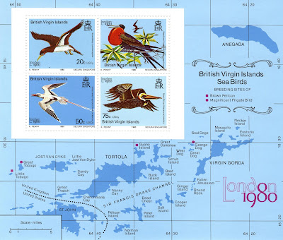
BRITISH VIRGIN ISLANDS


BRITISH VIRGIN ISLANDS.

World Philatelic Exhibition. "London 1980". Sea Birds.
Map of the British part of the Virgin rchipielago.
Minisheet issued on 06.05.1980.
20 + 25 + 50 + 75 cents of United States dollar.
Printing: Offset litography.
Size: 152 x 130 mm.

Catalogs
- Michel No. BL13.
- Scott No. 388a.
- StampWorld No. 387-390.
- Stanley Gibbons No. MS443.
- Yvert et Tellier No. BF 14.

The British Virgin Islands, officially the Virgin Islands, are a British Overseas Territory in the Caribbean, to the east of Puerto Rico and the U.S. Virgin Islands and north-west of Anguilla. The islands are geographically part of the Virgin Islands archipelago and are located in the Leeward Islands of the Lesser Antilles and part of the West Indies. The British Virgin Islands consist of the main islands of Tortola, Virgin Gorda, Anegada, and Jost Van Dyke, along with more than 50 other smaller islands and cays. About 16 of the islands are inhabited. The capital, Road Town, is on Tortola, the largest island. The total area of the territory is 153 km2 (59 sq mi).

11/06/2021

FINLAND


FINLAND / SUOMI.

Definitive stamps.
Pyhäkoski Power Plant.
Stamp issued on 24.05.1959.
Face value: 75 Finnish markka.
Design: Olavi Vepsäläinen (1927-1993).
Engraving: Reijo Achrén.
Printing: Recess.
Print: 10,000,000 copies.
Size: 34 x 24 mm.

Catalogs
- AFA No. 516.
- LaPe Finland No. 508.
- Michel No. 508.
- Scott No. 363.
- StampWorld No. 515.
- Stanley Gibbons No. 557.
- Yvert et Tellier No. 485.

The Pyhäkoski hydroelectric power station is located in Muhos (Oulu province, North Ostrobothnia region) and is the third power station upstream of the Oulujoki river. It has been designed by the architect Aarne Ervi. Construction began in February 1941 and was halted during WWII; when the war ended in autumn 1944, construction continued at full capacity. Concrete work for the reservoir was completed in 1948 and the water was able to be raised to its maximum regulating height, 32 m (105 ft). The machinery was installed after this. The first set of machinery was connected to the electrical grid in April 1949, the second and third in 1951.

NORWAY


NORWAY.

Pro National Tourist Association.
The North Cape.
First stamp in a set of 3, issued on 01.04.1943.
Vace value: 15 + 25 Norwegian øre.
Printing: Photogravure.
Print: 520,000 copies.
Size: 30 x 24 mm.

Catalogs
- AFA No. 290.
- Michel No. 284.
- Nordeskatalogen No. 311.
- Scott No. B28.
- StampWorld No. 292.
- Stanley Gibbons No. 349.
- Yvert et Tellier No. 246.

The North Cape (Norwegian: Nordkapp; Northern Sami: Davvenjárga) is a promontory located on the island of Magerøya, in northern Norway, in the community of Nordkapp. Its cliff, 307 m (1,007 ft) high, is often considered the northernmost point in Europe. However, neighboring Cape Knivskjellodden lies about 1,450 m (4,760 ft) further north and is the northernmost point on the continent. A road to the North Cape was first built in 1956. The North Cape was named by the English navigator Steven Borough, captain of the Edward Bonaventure, which sailed past in 1553 in search of the Northeast Passage.
This postage stamp wa issued during the German occupation of Norway (1940-1945). Shortly after, in December 1943, the battle of the North Cape took place between German and British naval forces.

10/06/2021

CHILE


CHILE.

1st anniversary of the Chilean expedition to the Himalayas.
Mount Gasherbrum II.
Stamp issued on 09.07.1980.
Face value: 15 Chilean pesos.
Printed by Casa de Moneda de Chile.
Printing: Offset lithography.

Catalogs
- Michel No. 933.
- Scott No. 572.
- StampWorld No. 906.
- Stanley Gibbons No. 853.
- Yvert et Tellier No. 544.

Chilean mountaineers Claudio Lucero, Gastón Oyarzún, Iván Vigoroux, Jorge Bassa, Jorge Quintero, Héctor Zúñiga, Rubén Lamilla, Nelson Muñoz and Claudio Gálvez participated in the first Chilean expedition to the Himalayas, and stated that on June 9, 1979 they reached the top of Mount Gasherbrum II. However, some specialists questioned the authenticity of this feat, which has been called into question.

Mount Gasherbrum II (Urdu, گاشر برم -2; Chinese, 加舒 ), also known as K4 or Moravi II, is the thirteenth highest mountain on Earth and is located in the Karakoram mountain range (the westernmost sector of the Himalayas), on the border between the Gilgit-Baltistan region, in Pakistan, and the autonomous region of Xinjiang, in China. Its height is 8,034 m (26,358 ft) above sea level. In 1856, Thomas George Montgomerie, a British member of the Royal Engineers, participated in the Great Trigonometric Topography Project expedition in Indian and Pakistani territory, sighted the mountain and named it K4, The first recorded ascent took place on July 7, 1956 by an Austrian expedition formed by Fritz Moravec, Josef Larch and Hans Willenpart.

ANDORRA


ANDORRA (French post).

Tourism.
Angonella Lakes.
Stamp issued on 28.06.1986.
Face value: 2.20 French francs.
Design: Sainson.
Printing: Photogravure.
Print: 633,989.

Catalogs
- AFA No. 371.
- Edifil No. 372.
- Michel No. 372.
- Scott No. 347.
- StampWorld No. 372.
- Stanley Gibbons No. 385.
- Yvert et Tellier No. 351.

The Angonella Lakes (Catalan: Estanys de l’Angonella) are a group of three small lakes in the Pyrenees located near the town of Llorts, to the northwest of the parish of Ordino, very close to the border with France. They are in a circus of glacial origin.

09/06/2021

CROATIA


CROATIA / HRVATSKA.

The Rad Lake (Crveno jezero).
Minisheet issued on 08.06.2007.
Face value: 10 Croatian kuna.
Design: Orsat Franković (b. Dubrovnik, 1971) and Ivana Vučić (b. Zagreb).
Printing: Offset lithography.
Print: 30,000 copies.
Size: 112 x 73 mm.

Catalogs
- AFA No. A905.
- Michel No. BL29.
- Scott No. 655.
- StampWorld No. 812.
- Stanley Gibbons No. MS896.
- Yvert et Tellier No. BF 30.
- Croatian Post No. BL20.

Red Lake (Croatian: Crveno jezero) is a sinkhole, formed by the fall of a vault, containing a karst lake next to the town of Imotski, Dalmatia, near the border with Bosnia and Herzegovina. It is known for its many remarkably tall caves and cliffs, reaching over 241 m (791 ft) above normal water level and continuing below water level. The total explored depth of this sinkhole is approximately 530 m (1,739 ft) with a volume of some 25 to 30 million cubic meters, making it the third largest sinkhole in the world. The water leaves the basin through underground waterways that descend below the level of the lake bottom. The deepest known point in the lake is 4 meters below sea level. The sinkhole is named after the reddish-brown color of the surrounding cliffs, colored by iron oxides.

-
Thanks to Dragan Buškulić for his contribution (https://worldofstamp2.wordpress.com/).

08/06/2021

BRITISH GUIANA


BRITISH GUIANA.

Definitive stamps.
Kaieteur Falls and King George VI.
Second stamp in a set of 12, issued on 01.02.1938.
Face value: 2 Guyanese cents.
Printing: Recess.
Size: 28 x 33 mm.

Catalogs
- Michel No. 177.
- Scott No. 231.
- StampWorld No. 179.
- Stanley Gibbons No. 309.
- Yvert et Tellier No. 163.

Kaieteur Falls is a waterfall on the Potaro River, in the central territory of Essequibo, Guyana. It is currently located in the Kaieteur National Park, in the Potaro-Siparuni region, which is claimed by Venezuela as part of the Guayana Esequiba. It is 226 m (741 ft) high. The Potaro River empties into the Essequibo River, which is one of the longest and widest rivers in South America. The first European to see the falls, on April 24, 1870, was Charles Barrington Brown, one of two British geologists appointed as government surveyors for the Colony of British Guiana.

-
Thanks to R. Gómez-Val for his contribution.

CANADA


CANADA.

Landscapes.
Mount Hurd.
First stamp in a set of 5, issued 05.12.1928.
Face value: 10 cents of Canadian dollar.
Design based in a painting of Frederic Marlett Bell-Smith (1846-1923).
Printing: Recess.
Print: 36,077,000 copies.
Size: 39 x 28 mm.

Catalogs
- Michel No. 134.
- Scott No. 155.
- StampWorld No. 128.
- Stanley Gibbons No. 281.
- Yvert et Tellier No. 135.

Mount Hurd is a Canadian mountain in the Ottertail Range of the Rocky Mountains in British Columbia. It was named after Major Marshall Farnam Hurd (1823-1903), a Canadian Pacific Railway engineer and explorer. Its height is 2,966 m (9,731 ft) above sea level. Precipitation runoff from Mount Hurd drains into tributaries of the Kicking Horse River which is a tributary of the Columbia River.

07/06/2021

HUNGARY


HUNGARY / MAGYARORSZÁG.

Danube Bridges.
Minisheet issued on 12.02.1985.
Face value: 20 Hungarian forint.
Printing: Offset lithography.
Print: 278,300 copies.
Size: 65 x 80 mm.

Catalogs
- AFA No. 3628.
- Michel No. BL176A.
- Philatelia Hungarica No. 3695.
- Scott No. 2909.
- StampWorld No. 3763.
- Stanley Gibbons No. MS3615.
- Yvert et Tellier No. BF 178.

The minisheet shows a map with the course of the Danube River, where the bridges that cross it in Germany, Austria, Slovakia, Hungary and northern Serbia are indicated. Represented are the Buda Castle (Hungarian: Budavári Palota), built in 1265, renovated in the 18th century and rebuilt after WW2; and the 378.3 m (1,241 ft) Elisabeth Bridge (Hungarian: Erzsébet híd) built between 1961 and 1964 to replace the original eclectic flamboyant style bridge, built between 1897 and 1903 and subsequently destroyed during the WW2.