28/02/2021

VANUATU


VANUATU.

Tanna and Aniwa Islands map, and Yasur volcano.
Eighth stamp in a set of 15, issued on 30.07.1980 (issue in French language).
Face value: 40 New Hebrides francs.
Printing: Offset lithography.

Catalogues
- Michel No. 581.
- Scott No. 287a.
- StampWorld No. 21.
- Stanley Gibbons No. 294F.
- Yvert et Tellier No. 590.

Tanna Island is 40 km (25 mi) long and 19 km (11.8 mi) wide, with a total area of ​​ 550 km² (210 sq mi). Its population is about 30,000 inhabitants, which makes it one of the most populated islands in Vanuatu. The administrative capital of the island is Isangel, on the western coast. Its maximum height is Mount Tukosmera of 1,084 m (3,556 ft). Mount Yasur, an active volcano 361 m (1,184 ft) high, is located on the southeast coast. James Cook was the first European to visit the island, inhabited by Melanesians, in August 1774, attracted by the luminosity of the volcano. In the 19th century, merchants and missionaries (mainly Presbyterians) and some whaling ships arrived. There is an airport to the northwest of the island.

Aniwa is a small 8 km² (3 sq mi) coral atoll that rises just 42 m (138 ft) above sea level, located about 24 km (15 mi) northeast of Tanna Island. To the northwest is the Itcharo (Tiaro) lagoon, open to the sea. It also has a small airport. Its population is about 350 inhabitants. Its first settlers came from Samoa, and were not Melanesians as in other islands of Vanuatu.

CHINA PEOPLE'S REPUBLIC


CHINA PEOPLE’S REPUBLIC / 华人民共和国.

Huangguoshu Waterfall.
Stamp issued (in minisheet) on 22.07.2001.
Face value: 8 Chinese renminbi yuan.
Printing: Offset lithography.
Size: 40 x 60 mm.

Catalogues
- Michel No. 3263 / BL99.
- Scott No. 3123.
- StampWorld No. 3330.
- Stanley Gibbons No. MS4609.

Huangguoshu Waterfall (in simplified Chinese, 黄果树瀑布; in traditional Chinese: 黃果樹瀑布, 'Yellow-Fruit Tree Waterfalls'), is one of the largest waterfalls in China and East Asia, located on the Baishui River (白水河) in Anshun, Guizhou province. It is 77.8 m (255 ft) high and 101 m (331 ft) wide. It is in the Huangguoshu Waterfall National Park. The Water-Curtain Cave named Shuiliandong (水帘洞) is a 134 m (440 ft) long naturally formed cave located in the back of the waterfall.

NEWFOUNDLAND


 NEWFOUNDLAND.

Definitive stamps.
Map of Newfoundland.
Stamp issued on 03.01.1928.
Face value: 1 cent.
Printing: Recess.
Size: 24.5 x 31 mm.

Catalogues
- Michel No. 129.
- Scott No. 145.
- StampWorld No. 137.
- Stanley Gibbons No. 164.
- Yvert et Tellier No. 131.

The island of Newfoundland (in French, Terre-Neuve; in Miꞌkmaq, Taqamkuk) is located in the Atlantic Ocean, off the coast of North America, and was inhabited by Paleo-arctic tribes. The first historical data on the island indicate that it was visited by the Icelandic explorer Leif Eriksson in the 11th century, who called it Vinland. Later, Portuguese, Spanish, French, Dutch and English fishermen and whalers came to its shores. After the settlement of the first Europeans, English, Irish, Scots and French, the colonists named the island Terra Nova, a name given to it by the Portuguese. On August 5, 1583, Humphrey Gilbert claimed the island as an overseas colony of England: Newfoundland is considered the oldest colony in Great Britain. It was administratively organized as a colony in 1825, was autonomous from 1855 to 1934, and maintained Dominion status (which included the island of Newfoundland and a part of Labrador Peninsula, see the map on the stamp) from 1907 to 1949. Between June and July 1948, a 52.3% of the population of the colony voted  in favor of joining Canada as a province. The union officially became effective one minute before midnight on March 31, 1949.

27/02/2021

MADAGASCAR


MADAGASCAR / REPOBLIKA MALAGASY.

Tourism.
Ranomafana National Park.
First stamp in a set of 4, issued on 07.05.1962.
Face value: 10 Malagasy francs.
Printing: Recess.

Catalogues
- Michel No. 478.
- Scott No. 328.
- StampWorld No. 527.
- Stanley Gibbons No. R 40.
- Yvert et Tellier No. 365.

Ranomafana National Park is located southeast of Madagascar, in the province of Fianarantsoa. It has 416 km² (161 sq mi) of humid tropical forest, which is home to numerous rare species of flora and fauna, such as lemurs, 130 species of frogs, and bird species including ground rollers, blue vangas, and brown mesites. The park was established in 1991 with the purpose of conserving the unique diversity of the local ecosystem and reducing human pressure on protected areas, and is part of the Atsinanana Rainforest denomination chosen as a World Heritage Site by Unesco in 2007. Since 2010 it is also included in the World Heritage Site in Danger list. The stamp shows the former Relais de Ranomafana (now Hôtel Thermal).

PARAGUAY


PARAGUAY.

America issue.
Ita Pyta Punta, Paraguay river.
Stamp issued on 31.10.1990.
Face value: 50 Paraguayan guaraní.
Design: Reproduction of a painting by Héctor Da Ponte (1879-1956).
Printed by Talleres de Valores Fiscales e Impresiones, Asunción.
Printing: Offset lithography.

Catalogues
- Michel No. 4510.
- Scott No. 2350.
- StampWorld No. 4537.
- Stanley Gibbons No. 1306.

Itá Pytã Punta, in Guaraní spelling (which means “Point of the red stone”) is a small fluvial peninsula in the shape of a promontory, 2 hectares in area, located on the Paraguay River between the Itá Pytã Punta and San Antonio neighborhoods of the city of Asunción, capital of Paraguay. It is an extinct volcano of which the current Tacumbú and Lambaré hills are testimonies, whose composition is formed by sedimentary and volcanic igneous rocks dating from the Eocene, transformed by the erosion of the river.

SOVIET UNION


SOVIET UNION / СОЮЗ СОВЕТСКИХ СОЦИАЛИСТИЧЕСКИХ РЕСПУБЛИК.

Active Volcanoes of Kamchatka.
Klyuchevskoi Volcano.
First stamp in a set of 3, issued on 30.11.1965.
Face value: 4 Russian kopek.
Deseign: L. Sharov.
Stamp: 4,000,000 copies.
Size: 52 x 24 mm.

Catalogues
- Michel No. 3138.
- Scott No. 3117.
- StampWorld No. 2937.
- Stanley Gibbons No. 3210.
- Yvert et Tellier No. 3033.
- Zagorsky No. 3189.

Klyuchevskoi (in Russian, Ключевская сопка), standing 4,835 m (15,863 ft) tall as of eruption of 2020, is a stratovolcano, the highest mountain on the Kamchatka Peninsula, in the Russian Far East, and the highest active volcano of Eurasia. Its steep, symmetrical cone towers about 60 kilometers (37 mi) from the Bering Sea. From 1996 the volcano is part of the natural Volcanoes of Kamchatka UNESCO World Heritage Site. Its first recorded eruption occurred in 1697, and it has been almost continuously active since then, as have many of its neighboring volcanoes. The most recent eruptions were recorded in the years 2002, 2005, 2009, 2010, 2012, 2013, 2017 and 2020. It was first climbed in 1788 by Daniel Gauss and two other members of the Billings Expedition. No other ascents were recorded until 1931, when several climbers were killed by flying lava on the descent. The Klyuchevskoi is considered sacred by some indigenous peoples, who see it as the place where the world was created.

ISRAEL


ISRAEL / יִשְׂרָאֵל‎ - إِسْرَائِيل

Definitive airmail stamps.
Lion Rock, Negev.
Stamp issued on 06.04.1954.
Face value: 150 Israeli prutot.
Printing: Offset lithography.
Size: 40 x 26 mm.

Catalogues
- Israel Philatelic Federation No. 107.
- Michel No. 83.
- Scott No. C12.
- StampWorld No. 83.
- Stanley Gibbons No. 79.
- Yvert et Tellier No. PA 12.

Lion Rock (or Frog Rock) is one of many eroded rocks found in the Negev desert, southern Israel. This is located in the area of Ma'ale Akrabim (in Hebrew, מעלה עקרבים), next to the road that connects Be'er Sheva (בְּאֵר שֶׁבַע) and the port of Eilat (אֵילַת), in the Red Sea.

26/02/2021

SOUTH WEST AFRICA


SOUTH WEST AFRICA / SUIDWES-AFRIKA - ZUIDWEST-AFRIKA.

Landmarks.
Sesriem Canyon.
Second stamp in a set of 4, issued on 03.03.1988.
Face value: 30 cents of South-African rand.
Design: Johan van Niekerk.
Printing: Offset lithography.

Catalogues
- Michel No. 622.
- Scott No. 599.
- StampWorld No. 621.
- Stanley Gibbons No. 492.
- Yvert et Tellier No. 579.

Sesriem is a natural canyon carved by the Tsauchab river in the local sedimentary rock, about a kilometre (0.6 mile) long and up to 30 m (100 feet) deep. The name Sesriem is Afrikaans and means "six rawhide thongs", given by settlers on the Dorsland Trek who had to join six such thongs in order for a bucket to reach the water. Sesriem Canyon is only 2 m (6.5 feet) wide in some places, and has a portion that permanently contains water, which many animals use.

ITALY


ITALY / ITALIA.

Italy regions series. Sardinia.
Simplified map of Sardinia.
Fourth stamp in a set of 4, issued on 16.03.2007.
Face value: 0.60 euro.
Design: Tiziana Trinca.
Printed by Officina Carte Valori dell'I.P.Z.S. (Istituto Poligrafico e Zecca dello Stato) S.p.A., Roma.
Printing: Photogravure.
Print: 3,500,000 copies.
Size: 40 x 30 mm.

Catalogues
- Michel No. 3166.
- Sassone No. 2955.
- Scott No. 2799.
- StampWorld No. 3171.
- Stanley Gibbons No. 3071.
- Unificato No. 3005.
- Yvert et Tellier No. 2922.

Sardinia (in Italian, Sardegna; in Sardinian, Sardìgna or Sardìnnia; in Catalan, Sardenya), is an island located south of Corsica, from which it is separated by the Strait of Bonifacio, between the seas of Sardinia (to the west) and Tyrrhenian (to the east), both belonging to the Mediterranean Sea. It has an area of 24,100 km2 (9,305 sq mi) and in 2020 its population was just over 1,600,000 inhabitants. It is an autonomous region of the Italian State, divided into four provinces (Nuoro, Oristano, Sassari and Sud Sardegna) and a metropolitan city (Cagliari, capital of the Region). It has two official languages: Italian and Sardinian (with its dialect variants), and a variant of Catalan in Alghero (l’Alguer). The island is predominantly mountainous, with the Gennargentu range standing out in its center, with Punta La Marmora, at 1,834 m (6,017 ft), as the highest peak. In front of its coasts there are numerous islands and islets; the largest are Sant’Antioco (109 km², 42 sq mi), Asinara (52 km², 20 sq mi), San Pietro (50 km², 19.3 sq mi), La Maddalena (20 km², 7.7 sq mi) and Caprera (16 km², 6.18 sq mi).

-
Thanks to Fadda Giuseppe for his contribution.

CUBA


CUBA.

Tourism. Cuba's cays.
Cayo Ensenachos, and bird (Kentish plover, Charadrius alexandrinus).
Fifth stamp in a set of 6, issued on 08.05.2007.
Face value: 50 cents of Cuban peso.
Printing: Offset lithography.
Size: 48 x 31.5 mm.

Catalogues
- Michel No. 4936.
- Scott No. 4707.
- StampWorld No. 4952.
- Stanley Gibbons No. 5072.
- Yvert et Tellier No. 4462.

Ensenachos Bay (in Spanish, Cayo Ensenachos or Cayo Los Ensenachos) is a 2 km² (0.77 sq mi) island to the north of Cuba, belonging to the archipelago of Cayos de la Herradura, in the province of Villa Clara. It has good beaches frequented by tourism, protected by a coral reef. It is connected to the mainland by a road built on the bed of the insular shelf between 1989 and 1999. It has no stable population.

NEW ZEALAND


NEW ZEALAND / AOTEAROA.

Definitive stamps.
Tongariro National Park.
Ninth stamp in a set of 12, issued on 01.09.1960.
Face value: 3 New Zealand shilling.
Printing: Photogravure.
Size: 41 x 25 mm.

Catalogues
- Michel No. 409.
- Scott No. 349.
- StampWorld No. 425.
- Stanley Gibbons No. 798.
- Yvert et Tellier No. 398.

Tongariro National Park, established in October 1887, is the oldest national park in New Zealand. It covers 795.96 km2 (307.32 sq mi) and contains a considerable part of the North Island Volcanic Plateau, with three active volcanoes: Mount Ruapehu, 2,797 m (9,177 ft), Mount Ngāuruhoe, 2,291 m (7,516 ft), which is the one seen on the stamp, and Mount Tongariro, 1,978 m (6,490 ft). Ngāuruhoe volcano erupted 45 times in the 20th century, most recently in 1977. Water has filled some of craters and has formed, among others, the Blue and the Emerald Lakes. The park has been acknowledged by UNESCO as a World Heritage Site of mixed cultural and natural values.

SWEDEN


SWEDEN / SVERIGE.

Waterfall in Stora Sjöfallet National Park. 
Stamp issued on 02.04.1974.
Face value: 35 øre.
Design: S. T. Karlsson.
Engraving: Majvor Franzén (b. 1938).
Printing: Recess.
Print: 10,300,000 copies.
Size: 32 x 27 mm.

Catalogues
- AFA No. 850.
- Facit No. 865.
- Michel No. 844.
- Scott No. 1039.
- StampWorld No. 846.
- Stanley Gibbons No. 784.
- Yvert et Tellier No. 827.

Stora Sjöfallet National Park (in Swedish, Stora Sjöfallets nationalpark), established in 1909, is located in Norrbotten county in northern Sweden, in the municipalities of Gällivare and Jokkmokk, 26 km (16.15 mi) from the Arctic Circle and near the border with Norway. Its area is 1,278 km² (494.4 sq mi). Inside is the lake system of the Lule River. It is part of Natura 2000, the network of protected areas of the European Union. The park takes its name from the large waterfall of the same name (Stour Muorkkegårttje in the Sámi language) on the Lule River. In the park is the Akka Massif (Áhkká, in the Sámi language), in the Scandinavian Alps, whose highest summit is the Stortoppen (Sarektjåkkå), 2,015 m (6,611 ft).

25/02/2021

CAPE VERDE


CAPE VERDE / CABO VERDE - KABU VERDI (Portuguese colony).

Centenary of the birth of Admiral Gago Coutinho.
Map of the first flight Lisbon - Rio de Janeiro (1922).
Stamp issued on 17.02.1969.
Face value: 30 Portuguese escudos.
Printing: offset lithography.

Catalogues
- Afinsa Mundifil No. 339.
- Michel No. 358.
- Scott No. 355.
- StampWorld No. 353.
- Stanley Gibbons No. 419.
- Yvert et Tellier No. 357.

Carlos Viegas Gago Coutinho (Lisbon, February 17, 1869 - February 18, 1959) was an air navigator, historian and officer of the Portuguese Navy with the position of Admiral. As of 1898 he dedicated himself to establishing border delimitations in the Portuguese overseas territories, for which he made several flights. The most notable was the first air crossing of the South Atlantic with Sacadura Cabral (1881-1924): they left Lisbon on March 30, 1922 and, via Las Palmas de Gran Canaria, São Vicente Island (Cape Verde), Fernando de Naronha and the Brazilian towns Recife, Salvador de Bahia, Porto Seguro and Vitória, finally landed in Rio de Janeiro on June 17, after a 79-day journey. In the last years of his life, he devoted himself to the study of Portuguese discoveries and navigations, writing several works that he ended up compiling in his Náutica dos Descobrimentos.

THAILAND


THAILAND / ประเทศไทย

Chao Phraya River.
First stamp in a set of 4, issued on 05.06.2017.
Face value: 3 Thai bath.
Design: Thaneth Ponchaiwong.
Printing: Offset lithography.
Printed by Cartor Security Printing, Co. Ltd, Meaucé (Eure-et-Loir, France).
Print: 500,000 copies.
Size: 65 x 30 mm.

Catalogues
- Michel No. 3645.
- Scott No. 2963.
- StampWorld No. 3740.
- Yvert et Tellier No. 3405.

Chao Phraya River (in Thai, แม่น้ำ เจ้าพระยา) is the longest and mightiest river in Thailand. It is 372 km (231 mi) long, begins in the north of the country and empties into the Gulf of Thailand, on the southern outskirts of the city of Bangkok. It is an important route for river transport and irrigates part of a highly productive agricultural valley; rice cultivation is very important in its delta. Its name, however, is applied only to the lower section, which begins at the confluence of the Nan (740 km, 460 mi) and Ping (658 km, 409 mi) rivers, in Nakhon Sawan Province, where several cities settle. 

24/02/2021

LATVIA


LATVIA / LATVIJA.

Nature monuments.
Vaiķi Boulder (Vaiķu dižakmens).
Stamp issued on 07.06.2008.
Face value: 22 Latvian santims.
Design: Ludis Danilāns (b. 1956).
Printing: Offset lithography.
Print: 3,000,000 copies.
Size: 32 x 32 mm.

Catalogues
- AFA No. 735.
- Michel No. 735.
- StampWorld No. 729.
- Stanley Gibbons No. 730.
- Yvert et Tellier No. 709.

Vaiķi Boulder (in Latvian, Vaiķu dižakmens), also known as Napoleon Boulder, is a rock produced by erosion located in the Vīpe Parish (Krustpils municipality, Latgale region), of about 650 inhabitants, on the right bank of the Daugava river. The easily accessible rock is made of red crystal granite and is 7.5 m (24.6 ft) long, 5.7 m (18.7 ft) wide, 2.6 m (8.53 ft) high, and 22.30 m (73.16 ft) in circumference, and its volume is about 50 m3 (1,766 ft3). There are two legends about the Boulder: one says that it was left there by the devil; the other, that Tsar Peter I of Russia and Napoleon had lunch on the stone.

BERMUDA


BERMUDA.

Historical maps.
Antique map by François Desbruslins (1740).
Fourth stamp in a set of 5, issued on 14.05.1979.
Face value: 25 cents of Bermudian dollar.
Printing: Offset lithography.
Size: 48 x 32 mm.

Catalogues
- Michel No. 372.
- Scott No. 383.
- StampWorld No. 375.
- Stanley Gibbons No. 407.
- Yvert et Tellier No. 373.

François Desbruslins (1709-17??) was a French engraver active in Paris from approximately 1729 to 1757. He engraved numerous maps for various French cartographers. The map reproduced on the stamp, engraved by Desbrulins in 1740, is the work of the French cartographer, architect and draftsman Philippe Buache (Paris, February 7, 1700 - January 24, 1771), who in 1729 was named the King's First Geographer. In 1739 he released a map that represents the south pole of the Earth, mentioned with frequency as an indication of a knowledge of the Antarctic continent in remote times, even before it was covered by glacial ice. He was a member of the French Academy of Sciences and stood out especially for having established the division of the globe by river and sea basins, subordinate to each other. He have published, among other geographical works, an Carte physique et profil du canal de la Manche et d'une partie de la mer du Nord où se voit l'état actuel des profondeurs de la Mer (1751) and numerous memoirs.

CANADA


CANADA.

Kluane National Park and Reserve.
Stamp issued on 27.04.1979.
Face value: 2 Canadian dollars.
Printing: Offset lithography and recess.
Print: 77,150,000 copies.
Size: 30 x 48 mm.

Catalogues
- Michel No. 726.
- Scott No. 727.
- StampWorld No. 726.
- Stanley Gibbons No. 885.
- Yvert et Tellier No. 703.

Kluane National Park and Reserve are two protected areas in the southwest corner of the territory of Yukon, bordering British Columbia to the south and Alaska to the west. It was provisionally established in 1972 waiting to negotiate its legal status with the natives of the place, and in 1993 it became definitively a National Park with an area of 22,013 km2 (8,499 sq mi), while the eastern part, about 5,900 km2 (2,300 sq mi) was left as a reserve. The park is home to Canada's highest mountain, Mount Logan, at 5,959 m (19,551 ft), which is part of the Saint Elias Mountains. Mountains and glaciers cover 83% of the park area.

-
Thanks to Kazimierz R. Leszczyński for his contribution (http://leszkarozdub.blogspot.com).

23/02/2021

TUNISIA


TUNISIA / تونس (French occupation).

Definitive stamps.
Rock and village of Takrouna.
Fourth stamp in a set of 16, issued on 29.05.1954.
Face value: 4 Tunisian francs.
Printing: Recess.
Print: 830,000 copies.
Size: 22 x 26 mm.

Catalogues
- Michel No. 410.
- Scott No. 239.
- StampWorld No. 418.
- Stanley Gibbons No. 373.
- Yvert et Tellier No. 369.

Takrouna (in Tamazight, ⵜⴰⴽⵔⵓⵏⴰ; in Arabic, تكرونة) is a Tunisian town located on top of the rock of the same name, also known in French as Rocher Bleu, at an altitude of about 200 meters above sea level, north of the Kairouan plain and facing the Gulf of Hammamet. It is believed that it was founded by the descendants of a Amazigh (Berber) tribe that settled in Andalusia in the 8th century, after the final expulsion of the Moors from the Iberian Peninsula in 1609; however, the place had already been populated in times of the Roman Empire. Takrouna was the scene of the last major action by New Zealand troops in North Africa during World War II, before the surrender of Italy and Germany. The town has about 600 inhabitants that make up seven family nuclei, one of them of Andalusian origin.

VENEZUELA


VENEZUELA.

Federal Territory of Delta Amacuro.
Map of the territory.
Airmail. Fourth stamp of 9, issued on 13.02.1953.
Face value: 25 cents of Venezuelan bolívar.
Printing: Photogravure.
Printed by Courvoisier S.A., La Chaux-de-Fonds, Switzerland.
Print: 400,000 copies.
Size: 26 x 41 mm.

Catalogues
- Michel No. 901.
- Scott No. C449.
- StampWorld No. 921.
- Stanley Gibbons No. 1195.
- Yvert et Tellier No. PA 459.

Delta Amacuro is one of the 23 states of Venezuela. It is located in the northeast of the country in the Guayana region, in the Orinoco River delta, on the shores of the Atlantic Ocean. Its area is 40,200 km² (15,520 sq mi) and in 2011 its population was about 167,500 inhabitants. The area was documented for the first time in 1499 by Alonso de Ojeda, and visited in 1500 by Vicente Yáñez Pinzón. Diego de Ordaz was the first explorer to go up the Orinoco River from there in 1532. On October 3, 1899, the region was annexed to British Guiana, but in 1901 it was restored to Venezuela, which administered it as a Federal Territory until 2015 it was declared a federal state and Warao was recognized as a co-official language.

22/02/2021

BELGIUM


BELGIUM / BELGIË - BELGIQUE.

150th Anniversary of Division of Limburg.
Map of Limburg and 
its division between the Netherlands and Belgium in 1839.
Stamp issued on 30.09.1989.
Face value: 13 Belgian francs.
Printing: Photogravure.
Print: 8,100,000 copies.
Size: 28 x 39 mm.

Catalogues
- AFA No. 2397.
- Michel No. 2390.
- Scott No. 1327.
- StampWorld No. 2394.
- Stanley Gibbons No. 2998.
- Yvert et Tellier No. 2338.

After Belgium’s separation from the Netherlands in 1830, the two Limburg provinces (Lower Meuse), which had been unified under the French administration (1810-1815), were almost entirely integrated into the new Kingdom of Belgium. The Treaty of London, signed on April 19, 1839, by Great Britain, Austria, the German Confederation (led by Prussia), Russia and the Netherlands, established the division of Limburg between Belgium and the Netherlands. At the same time. Luxembourg lost two thirds of its territory, which became Belgian sovereignty. Thus the definitive borders of the independent Kingdom of Belgium, which was recognized internationally, were defined.

COLOMBIA


COLOMBIA.

International Geophysical Year.
Portrait of Francisco José de Caldas. 
First stamp in a sef of 3, issued on 12.05.1958.
Face value: 10 cents of Colombian peso.
Design: Imre Mosdóssy (1904-1995).
Printed by the 
ÖsterreichischeStaatsdruckerei (Imprenta Nacional de Austria).
Printing: Photogravure.
Print: 5,000,000 copies.
Size: 40 x 25 mm.

Catalogues
- Leo Temprano No. 895.
- Michel No. 827.
- Scott No. 680.
- StampWorld No. 809.
- Stanley Gibbons No. 933.
- Yvert et Tellier No. 547.

On December 1, 1959, the twelve countries that had carried out scientific activities in and around Antarctica during the 1957-1958 International Geophysical Year signed the Antarctic Treaty in Washington. The Treaty entered into force on June 23, 1961, and has been accepted by many other nations. The Treaty recognizes, among other things, the interest of all humankind that Antarctica continue to be used exclusively for peaceful purposes and shall not become the scene or object of international discord. The signatory countries were: Argentina, Australia, Belgium, Chile, France, Japan, New Zealand, Norway, South Africa, the Soviet Union, the United Kingdom, and the United States.

Francisco José de Caldas y Tenorio (Popayán, October 4, 1768 - Santafé, October 28, 1816) was a Colombian scientist, military engineer, geographer, botanist, astronomer, naturalist and journalist, hero of the independence of Colombia. For his erudition and many knowledge about so many disciplines he was known among his contemporaries as El Sabio (“The Sage”), epithet with which he went down in the history of Colombia. He was the creator of the first hypsometer.

VIETNAM


VIETNAM / VIỆT NAM.

6th centenary of the birth of Lê Lợi and commemoration of the Battle of Xương Giang.
Historical map of the development of the battle.
Stamp issued on 01.03.1986.
Face value: 1 Vietnamese 
đồng.
Printing: Offset lithography.
Size: 30 x 45 mm.

Catalogues
- Michel No. 1663.
- Scott No. 1605.
- StampWorld No. 809.
- Stanley Gibbons No. 919.
- Yvert et Tellier No. 668.

Lê Lợi (Lam Son, Thon Hoa Province, c. September 10, 1384 - September 5, 1433) who received the nickname Lam Sơn động chủ (Lord of Lam Son) and whose official title was Bình Định vương (Prince of Pacification), was a Vietnamese politician, rebel leader, and later monarch of the restored kingdom of Đại Việt, and founder of the second Lê dynasty after Đại Việt was conquered in 1407 and briefly incorporated into the Ming Empire of China. In 1418, Lê Lợi and his followers took up arms against the Ming laws and nine years later, in October 1427, after the victorious battle of Xương Giang (remembered on this stamp) they managed to drive the Ming armies out of Vietnam and liberated the country of Chinese rule. After ten years of war, Đại Việt regained its status as an independent state, officially recognized by the Ming Empire. The site of this battle was classified as a Special National Historic Site in 2020.

-
Thanks to Fadda Giuseppe for his contribution.

SPANISH SAHARA


SPANISH SAHARA / SAHARA ESPAÑOL (now Western Sahara, occupied by Morocco).

25th anniversary of the accession of General Franco to the Head of State, 1936-1961.
Map of the Spanish colony of Sahara.
First stamp in a set of 4, issued on 01.10.1961.
Face value: 25 cents of Spanish peseta.
Printing: Photogravure.
Printed by F.N.M.T. (Fábrica Nacional de Moneda y Timbre), Madrid.
Print: 450,000 copies.
Size: 35 x 41 mm.

Catalogues
- Edifil No. 193.
- Michel No. 224.
- Scott No. 114.
- StampWorld No. 217.
- Stanley Gibbons No. 190.
- Yvert et Tellier No. 179.

The territory of Western Sahara was gradually colonized by Spain since 1860. The first area occupied was the Río de Oro (ادي الذهب), to the south, where in 1884 the city of Villa Cisneros (now Dakhla [الداخلة]) was founded, to which later La Güera (الكويرة) and Tiris (part of the Adrar territory, ولاية آدرار, which currently belongs to Mauritania) were annexed. In 1912 the annexation of Saguía el Hamra (الساقية الحمراء) region was agreed with France, where in 1938 the city of El Aaiún (العيون) was founded, which would later become the capital of the entire colony of the Spanish Sahara (الصحراء الإسبانية), relegating Villa Cisneros. The total area of ​​the colony, mostly desert, was about 280,000 km². Its definitive limits were established in the Cintra agreements (April 2, 1958).
In 1968, the Advanced Organization for the Liberation of Saguia el Hamra and Río de Oro, known simply as the Liberation Movement, was founded in the city of Smara (السمارة), which was formally constituted on December 11, 1969 with the aim of achieving the independence from Western Sahara and was outlawed by the Spanish authorities. Later, on May 10, 1973, the Polisario Front (جبهة البوليساريو) was born in Zouérate (الزويرات, Mauritania), ready to fight for independence. Morocco and Mauritania had ambitions to seize the colony, and finally on November 6, 1975 King Hassan II of Morocco organized the so-called Green March, which crossed the internationally recognized border of the Spanish Sahara (which by then had already become a semi-metropolitan province of Spain) to the north. On February 26, 1976, Spain abandoned the territory, after which the Polisario Front proclaimed the Sahrawi Arab Democratic Republic (SADR) and launched a war of liberation of the territory, which would finally be annexed to Morocco despite the reluctance of the international community and the United Nations.

21/02/2021

AUSTRIA


AUSTRIA / ÖSTERREICH.

European Nature Preservation Year.
Krimml Waterfalls (Krimmler Wasserfälle).
Stamp issued on 19.05.1970.
Face value: 2 Austrian schilling.
Design: Otto Zeiller (1913-1988).
Engraving: Kurt Leitgeb (b. 1939).
Printing: Recess.
Print: 2,900,000 copies.
Size: 33 x 43 mm.

Catalogues
- AFA Bo. 1224.
- Michel No. 1325.
- Scott No. 862.
- StampWorld No. 1370.
- Stanley Gibbons No. 1576.
- Yvert et Tellier No. 1154.

Krimml Waterfalls (in German, Krimmler Wasserfälle), with a total height of 385 m (1,263 ft), are the highest waterfall in Austria. The falls are formed from the Krimmler Ache, a glacial stream, and are located near the village of Krimml, in the Hohe Tauern National Park (state of Salzburg), at an altitude of 1,090 m (3,576 ft). The waterfall descends in three steps of 145, 100 and 140 m.

FRENCH SOUTHERN AND ANTARCTIC LANDS


FRENCH SOUTHERN AND ANTARCTIC LANDS / 
TERRES AUSTRALES ET ANTARCTIQUES FRANÇAISES (TAAF).

Map of the East Island (île de l'Est), in the Crozet Islands.
Airmail stamp issued on 01.01.1996.
Face value: 20 French francs.
Design and engraving: Pierre Béquet (1932-2012).
Printing: Recess.
Size: 48 x 36 mm.

Catalogues
- Michel No. 349.
- Scott No. C136.
- StampWorld No. 350.
- Stanley Gibbons No. 357.
- Yvert et Tellier No. PA 137.

East Island (île de l’Est) is a part of the subantarctic archipelago of the Crozet Islands, south of the Indian Ocean, and is part of the French Southern and Antarctic Lands. It is the remainder of an ancient and powerful stratovolcano, heavily eroded by Quaternary glaciers that currently form valleys. With an area of ​​130 km2 (50 sq mi) it is the second largest island of the group. It is the most mountainous in the archipelago, with a high point, Pic Marion-Dufresne, of 1,090 m (3,580 ft), and a rugged coastline of high cliffs: Lesquin's 1,012 m (3,320 ft) cliff is considered the highest in the world. There is no human infrastructure; it is only occasionally visited by researchers. The island has been identified as an Important Bird Area (IBA) by BirdLife International as a breeding site for seabirds. The Island was discovered on January 24, 1772 by the French expedition of Marc-Joseph Marion Dufresne, who gave it the name île Aride. In the early 19th century it began to be frequented by British and New England seal hunters.

FINLAND


FINLAND / SUOMI.

Bothnian Sea National Park, with a small simplified map of Finland.
Stamp issued on 07.05.2012.
1st Class (not face value).
Design: Teemu Ollikainen.
Printed by Joh. Enschedé Stamps, Haarlem, Netherlands.
Printing: Offset lithography.
Print: 4,000,000 copies.
Size: 24.5 x 34.5 mm.

Catalogues
- AFA No. 2204.
- Michel No. 2183.
- Scott No. 1410.
- StampWorld No. 2194.
- Stanley Gibbons No. 2112.
- Yvert et Tellier No. 2150.

The Bothnian Sea National Park (in Finnish, Selkämeren kansallispuisto; in Swedish, Bottenhavets nationalpark) is located in southwest Finland, on the shores of the Bothnian Sea, in the Baltic. It was established in 2011. It has an area of 913 km² (352.5 sq mi), 98% of which is water and is accessible only by boat. It is characterized by its rich wildlife.

NEPAL


NEPAL / नेपाल.

Mount Everest.
Stamp issued on 14.03.2007.
Face value: 5 Nepalese rupee.
Size: 40 x 30 mm.

Catalogues
- Michel No. 881.
- StampWorld No. 878.
- Stanley Gibbons No. 895.
- Yvert et Tellier No. 849.

Mount Everest (in Nepali, सगरमाथा [Sagarmāthā]; in Tibetan, ཇོ་མོ་གླང་མ [Chomolungma]; in Chinese, 珠穆朗 [Zhūmùlǎngmǎ]), in the Himalayas, 8,848.86 m (29,031.7 ft) high above sea level, it is the highest mountain on the earth's surface. It is located on the border between Nepal (on its south face) and Tibel, in China (on its north face). After several attempts, the Nepalese Tenzing Norgay and the New Zelander Edmund Hillary were the first to officially reach the summit, via the southeast ridge, on May 29, 1953. The first ascent up the north ridge was made by the Chinese mountaineering team of Wang Fuzhou, Gonpo and Qu Yinhua on May 25, 1960. The name by which the mountain is universally known, adopted by the Royal Geographical Society in 1865, is that of the British George Everest, who had been General Surveyor of India.

20/02/2021

BRAZIL


BRAZIL / BRASIL.

United Nations Conference on Environment and Development (UNCED).
Simplified map of Brazil.
Third stamp in a set of 3, issued on 03.06.1992.
Face value: 3000 Brazilian cruzeiros.
Design: 
Evelyn Grumach.
Printing: Offset lithography.
Print: 1,500,000 copies.

Catalogues
- Michel No. 2478.
- RHM No. C-1800.
- Scott No. 2369.
- StampWorld No. 2502.
- Stanley Gibbons No. 2538.
- Yvert et Tellier No. 2073.

The United Nations Conference on Environment and Development (UNCED), also known as the “Earth Summit”, was held in Rio de Janeiro from June 3 to 14, 1992. This global conference, held on the occasion of the 20th anniversary of the first Human Environment Conference in Stockholm, Sweden, in 1972, brought together political leaders, diplomats, scientists, representatives of the media and non-governmental organizations (NGOs) from 179 countries for a massive effort to focus on the impact of human socio-economic activities on the environment. 

GHANA


GHANA.

Definitive stamps.
Boti Falls.
First stamp in a set of 6, issued on 21.11.1991.
Face value: 50 Ghanaian cedi.
Printing: Offset lithography.
Size: 20 x 26 mm.

Catalogues
- Michel No. 1614A.
- Scott No. 1357A.
- StampWorld No. 1601.
- Stanley Gibbons No. 1640.

Boti Falls, formed by the Pawnpawn River (popularly known as Pomnpon), are located in the Boti Forest, in the Eastern Region of Ghana. There are actually two waterfalls in Boti: the upper and lower falls. The locals believe that one of the lower falls is male and the other female. When the volume of water is high, especially during the rainy season (between June and August), the two meet in what the locals describe as a "mating ceremony", in which the splashes of water create a rainbow. The pool formed at the base of the falls is very suitable for a refreshing swim. The highest waterfall has a height of about 30 m (98 ft). The place was declared public in 1961, after a dispute over its ownership.

MEXICO


MEXICO / MÉXICO.

Political map of Mexico.
Stamp issued in 11.1915.
Face value: 40 centavos of Mexican peso.
Printing: Recess.
Size: 34 x 25.5 mm.

Catalogues
- Michel No. 434.
- Scott No. 512.
- StampWorld No. 496.
- Stanley Gibbons No. 299.
- Yvert et Tellier No. 352.

Stamp issued in full development of the Mexican Revolution, which had broken out on November 20, 1910 and did not end until the revolutionary leader Francisco “Pancho” Villa was assassinated, on July 20, 1923.

19/02/2021

ESTONIA


ESTONIA / EESTI.

Estonian lighthouses.
Vilsandi lighthouse in Vilsandi Island.
Stamp issued on 20.01.1999.
Face value: 3.60 Estonian kroon.
Design: Roman Matkiewicz (b. Tallinn, 27.02.1966).
Printing: Offset lithography.
Print: 602,250 copies.

Catalogues
- AFA No. 366.
- Michel No. 339.
- Scott No. 356.
- StampWorld No. 372.
- Stanley Gibbons No. 328.
- Yvert et Tellier No. 330.

The island of Vilsandi, in the Baltic Sea, is located to the west of the island of Saaremaa, on which it depends administratively. It has an area of 9.4 km2 (3.63 sq mi), its length is 6.3 km (3.91 mi) and its maximum width is 2.3 km (1.43mi). It is connected by sea to the port of Papissaare, in Saaremaa. It was mentioned for the first time in 1645 with the Swedish name of Fylsandt. The island and its surroundings are part of the Vilsandi National Park. The lighthouse featured on the stamp, built in 1809, is located at the western end of the island.

POLAND


POLAND / POLSKA.

Historic maps.
Topographic map of Poland. Fragment of the Atlas geograficzny by Eugeniusz Romer (1908).
Third stamp in a set of 4, issued on 28.12.1982.
Face value: 8 Polish złotych.
Design: Jacek Brodowski (b. Kraków, 05.07.1943).
Printing: Offset lithography.
Print: 6,102,000 copies.
Size: 40.5 x 40.5 mm.

Catalogues
- AFA No. 2732.
- Fischer No. 2698.
- Michel No. 2846.
- Scott No. 2552.
- StampWorld No. 2847.
- Stanley Gibbons No. 2859.
- Yvert et Tellier No. 2659.

Eugeniusz Mikołaj Romer (Lwów, now in Ukraine, February 3, 1871 - Kraków, January 28, 1954) was a Polish cartographer and geopolitician, founder of modern Polish cartography. During the First World War, and having done extensive field work and completed his studies of tectonics and morphology, he settled in Vienna, where he compiled his Geograficzno-statystyczny atlas Polski ('Geographical and Statistical Atlas of Poland', 1916). He participated as an expert in the negotiations to establish the new borders of Poland and advised the Polish delegation at the Paris Peace Conference. In 1921 he founded the Polish Cartographic Institute, which was later named after him. After fleeing the German occupation of his hometown, in 1941 he was able to travel to London, where he collaborated as an expert with the Polish government in exile. He was a member of the Polish Academy of Sciences and other institutions, and vice president of the International Geographical Union. He also excelled as an encyclopedist. The map depicted on the stamp is reproduced from his Mały atlas geograficzny (‘Small Geographical Atlas’, 1908), one of his earliest and numerous works.

-
Thanks to Sylvester Dulewski for his contribution (https://birdsposta.blogspot.com/).

ARGENTINA


ARGENTINA.

Definitive stamps. Iguazu Falls.
Stamp issued on 01.12.1955.
Face value: Argentine pesos moneda nacional.
Design: Renato Garrasi (Garassi?, 1915-1990?).
Engraving: Volumnio Cerichelli.
Printing: Recess.
Printed by Casa de Moneda de la Nación, Buenos Aires.
Size: 44 x 34 mm.

Catalogues
- Cefiloza No. 722.
- Götig and Jalil No. 1052.
- Michel No. 628.
- Scott No. 639a.
- StampWorld No. 650.
- Stanley Gibbons No. 875a.
- Yvert et Tellier No. 549.

Iguazu Falls (in Spanish, Cataratas del Iguazú; in Guarani, Chororõ Yguasu; in Portuguese, Cataratas do Iguaçu), formed by the Iguazu River on the border of the Argentine province of Misiones and the Brazilian state of Paraná, are the largest in the world. Most of the falls (80%) are on the Argentine side, and at its confluence with the San Antonio River, the Iguazu River serves as the border between Argentina and Brazil. The falls have different heights; the largest is 82 m (269 ft). Its average flow is 1,756 m3 per second (62,010 ft3/s). The first European to register the existence of the falls was the Spanish Álvar Núñez Cabeza de Vaca in 1542, who called them “Saltos de Santa María”; However, the first to spot them had been Aleixo García, a castaway from the expedition of Juan Díaz de Solís, in 1524, when he crossed that region in search of the Sierra de la Plata. In 1934 the Argentine government established the Iguazú National Park, which was declared a World Heritage Site by Unesco in 1984.

18/02/2021

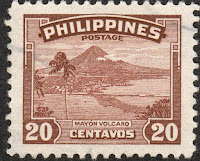
PHILIPPINES


PHILIPPINES / PILIPINAS.

Definitive stamps. Local motives.
Mayon Volcano.
Fifth stamp in a set of 7, issued on 23.03.1947.
Face value: 20 cents of Philippine peso.
Printing: Recess.

Catalogues
- Michel No. 466.
- Scott No. 508.
- StampWorld No. 472.
- Stanley Gibbons No. 633.
- Yvert et Tellier No. 329.

Mayon Volcano, also known as Mount Mayon, is a sacred and active stratovolcano in the province of Albay, on the large island of Luzon in the Philippines. The volcano with its surrounding landscape was declared a national park on July 20, 1938, the first in the nation. It was reclassified in 2000 and renamed as the Mayon Volcano Natural Park. It is the centerpiece of the Albay Biosphere Reserve, declared by UNESCO in 2016. Its height is 2,463 m (8,081 ft). Its cone is considered the most perfectly formed in the world due to its symmetry. Its first documented eruption is in 1616, and the most destructive so far was in 1814. More recently, the Mayon has experienced continuous emissions since 1999.

AUSTRALIA


AUSTRALIA.

Panoramas of Australia stamps.
Gariwerd - Grampians National Park (Victoria).
Second stamp in a set of 4, issued on 23.08.2002.
Face value: 1.65 Australian dollar.
Printing: Offset litography.
Size: 18.5 x 43 mm.

Catalogues
- Michel No. 2153.
- Scott No. 2078.
- Seven Seas Stamps No. 1989.
- StampWorld No. 2146.
- Stanley Gibbons No. 2220.
- Yvert et Tellier No. 2048.

The Grampians National Park (Gariwerd in the language of the Jadwatjali aborigines) is located in the Grampians region, in the state of Victoria. Its area is 1,672.19 km2 (645.6 sq mi). It was established on July 1, 1984 and declared a National Heritage Site on December 15, 2006 for being one of the richest Aboriginal rock art sites in Southeastern Australia and the entire country. The Grampian Mountains feature an astonishing series of sandstone mountain ranges of geological interest, and are a popular rock climbing destination. The highest peak is Mount William at 1,167 m (3,829 ft). Numerous waterfalls, such as the MacKenzie Falls, are located in the park.

GREECE


GREECE / ЕΛΛΑΣ.

Prefecture capitals.
Karpenisi (Evritania) and Mount Tymfristos.
Sixth stamp in a set of 12, issued on 12.10.1992.
Face value: 60 Greek drachma.
Printing: Offset lithography.
Print: 24,400,000 copies.
Size: 30 x 25 mm.

Catalogues
- AFA No. 1832A.
- Karamitsos No. 1921A.
- Michel No. 1817C.
- Scott No. 1654A.
- StampWorld No. 1799.
- Stanley Gibbons No. 1916B.
- Yvert et Tellier No. 1805B.

Karpenisi (in Greek, Καρπενήσι) is a town in central Greece, capital of the regional unit of Evrytania. It is located at an altitude of 975 m (3,200 ft), in the valley of the river Karpenisiotis (Καρπενησιώτης), a tributary of the Megdovas. The Mount Tymfristos (Τυμφρηστός), 2,315 m (7,595 ft), which rises north of the city, is part of the Pindus Mountains. In the area are the best ski slopes in Greece.