31/08/2021

BULGARIA


BULGARIA / БЪЛГАРИЯ.

Cape Kaliakra.
Sixth stamp in a set of 8, issued on 17.05.1968.
Face value: 13 Bulgarian stotinki.
Printing: Photogravure.
Print: 5,000,000 copies.
Size: 26 x 36 mm.

Catalogs
- Michel No. 1807.
- Scott No. 1686.
- StampWorld No. 1807.
- Stanley Gibbons No. 1800.
- Yvert et Tellier No. 1623.

Kaliakra (Bulgarian: Калиакра) is a cape in the Southern Dobruja region of the northern Bulgarian Black Sea coast, which ends with a long and narrow headland 12 km (7 mi) east of Kavarna.

-
Thanks to Dragan Buškulić for his contribution (https://worldofstamp2.wordpress.com/).

SOUTH KOREA


SOUTH KOREA /  대한민국

Paikryung Island.
Second stamp in a set of 2, issued on 10.04.1980.
Face value: 90 South Korean won.
Printing: Photogravure.
Size: 26 x 23 mm.

Catalogs
- Michel No. 1193.
- Scott No. 1220.
- StampWorld No. 1187.
- Stanley Gibbons No. 1376.
- Yvert et Tellier No. 1052.

The Paikryung or Baengnyeong Island (Korean: 백령도) is located in the Yellow Sea, west of the Ongjin Peninsula (North Korea), on the border between the Republic of Korea and North Korea, so it is usually a politically conflictive place. It is the westernmost point of South Korea. It has an area of 45.8 km2 (17.7 sq mi); its length is 8.45 km (5.25 mi) and its maximum width is 12.56 km (7.80 mi). Its population is about 4,250 inhabitants.

23/08/2021

VENEZUELA


VENEZUELA.

450th Anniversary of Discovery of Lake Maracaibo.
Map of Lake Maracaibo and portrait of Alonso de Ojeda.
Air Mail. Sixth stamp in a set of 9, issued on 18.12.1950.
Face value: 15 cents of Venzuelan bolívar,
Printed by Courvoisier, Switzerland.
Printing: Photogravure.
Print: 500,000 copies.

Catalogs
- Michel No. 604.
- Scott No. C318.
- StampWorld No. 624.
- Stanley Gibbons No. 880.
- Yvert et Tellier No. PA 312.

Lake Maracaibo is a coastal freshwater lake, similar to a large bay, located in the westernmost part of Venezuela, and between the states of Zulia, Trujillo and Mérida. It has an area of 13,210 km² (5,100 sq mi) and is the largest in South America: its length is 159 km (99 mi) and its maximum width, 108 km (67 mi). It is supposed to be between 20 and 36 million years old. In the extreme north it is connected to the Gulf of Venezuela (Caribbean Sea) by the Strait of Tablazo, 5.5 km (3.4 mi). It is fed by numerous rivers, the largest being the Catatumbo River. The Maracaibo basin is one of the most oil rich areas in the world, which began to be exploited in 1914. The lake also has numerous islands, some of sedimentary origin and others of tectonic origin. The shores of the lake were inhabited by the aborigens Añú, they called it Coquivacoa. There were also other tribes in the area, such as the Wayuu, the Caquetio and the Quiriquires. The first European to arrive to the lake there was the explorer Alonso de Ojeda (his name is misspelled on the stamp), in 1499.

20/08/2021

SLOVENIA


SLOVENIA / SLOVENIJA.

Malturjek Group and Alpine clematis.
First stamp in a set of 2, issued on 21.03.2002.
No face value (A).
Design: Zagorka Simić.
Printing: Offset lithography.
Print: 100,000 copies.
Size: 40.32 x 28.8 mm.

Catalogs
- Michel No. 392.
- Scott No. 487.
- Slovenika No. 586,
- StampWorld No. 376.
- Stanley Gibbons No. 538.
- Yvert et Tellier No. 361.

The Martuljek group (Slovenian: Martuljška skupina), sometimes also called the Špik group, is a mountain range in the Julian Alps that rises above the upper valley of the Sava River above Gozd Martuljek, in the north-west of the country. The area of this mountainous group with the valley of the Martuljek stream was declared a landscape park on January 27, 1949 and since 1981 it is part of the Triglav National Park. The highest peaks in this group are Oltar, at 2,621 m (8,599 ft); the Great Martuljek Ponza, 2,602 m (8,537 ft); Dovški križ, 2,542 m (8,340 ft); Little Martuljek Ponca, 2,502 m (8,208 ft); the Široka peč, 2,497 m (8,192 ft) and the Špik, 2,472 m (8,110 ft).

The flower depicted on the stamp is a Clematis alpina.

19/08/2021

UNITED STATES


UNITED STATES.

Acadia National Park, Maine.
Last stamp in a set of 3, issued on 02.01.1934.
Face value: 7 cents of U.S. dollar.
Printing: Recess.
Print: 15,000,000 copies.

Catalogs
- Michel No. 370.
- Scott No. 746.
- StampWorld No. 587.
- Stanley Gibbons No. 745.
- Yvert et Tellier No. 334A.

Acadia National Park is located along the mid-section of the Maine coast, southwest of Bar Harbor. The park preserves about half of Mount Desert Island, part of the Isle au Haut, the tip of the Schoodic Peninsula, and portions of 16 smaller outlying islands. It was established on July 8, 1916 as Sieur de Monts National Monument. In total, it encompasses 198.6 km2 (76.7 sq mi). Acadia has a rich human history, dating back more than 10,000 years ago with the Wabanaki people. The 17th century brought fur traders and other European explorers, while the 19th century saw an influx of summer visitors, then wealthy families.

18/08/2021

CHINA REPUBLIC (Taiwan)


REPUBLIC OF CHINA (Taiwan) / 中華民國 (臺灣).

Yangtze River.
Fouth stamp in a set of 5, issued on 15.05.1993.
Face value: 5 Taiwanese new dollars.
Printing: Offset lithography.
Print: 8,900,000 copies.
Size: 41 x 25.5 mm.

Catalogs
- Michel No. 2120.
- Scott No. 2899.
- StampWorld No. 2112.
- Stanley Gibbons No. 2130.
- Yvert et Tellier No. 2056.

The Yangtze or Yangzi (Chinese: 長江) is the longest river in Asia. It is the longest in the world to flow entirely within one country (the current People's Republic of China). It rises at Jari Hill in the Tanggula Mountains (Tibetan Plateau) and flows 6,300 km (3,900 mi) in a generally easterly direction to the East China Sea. Its drainage basin comprises one-fifth of the land area of continental China. The Yangtze has played a major role in the history, culture and economy of China. For thousands of years, the river has been used for water, irrigation, sanitation, transportation, industry, boundary-marking and war. The Yangtze flows through a wide array of ecosystems and is habitat to several endemic and threatened species including the Chinese alligator, the narrow-ridged finless porpoise and the Yangtze sturgeon, but also was the home of the extinct baiji and Chinese paddlefish. In recent years, the river has suffered from industrial pollution, plastic pollution, agricultural runoff, siltation, and loss of wetland and lakes, which exacerbates seasonal flooding. Some sections of the river are now protected as nature reserves. A stretch of the upstream Yangtze flowing through deep gorges in western Yunnan is part of the Three Parallel Rivers of Yunnan Protected Areas, a UNESCO World Heritage Site. 

-
Thanks to Dragan Buškulić for his contribution (https://worldofstamp2.wordpress.com/).

17/08/2021

INDONESIA


INDONESIA.

Musical instruments.
Western New Guinea (Irian Barat, now Papua Barat) map and genderang.
Sixth stamp in a set of 16, issued on 01.02.1967.
Face value: 2.50 Indonesian rupiah.
Printing: Photogravure.
Size: 25 x 32 mm.

Catalogs
- Michel No. 567.
- Scott No. 710.
- StampWorld No. 609.
- Stanley Gibbons No. 1145.
- Yvert et Tellier No. 503.
- Zonnebloem No. 568.

Western New Guinea (Irian Barat, from 1973 Irian Jaya, renamed Papua Barat in 2002) is the western portion of the island of New Guinea controlled by Indonesia since 1962. It is considered to be a part of Oceania. Following its proclamation of independence in 1945, the Republic of Indonesia took over all the former territories of the Dutch East Indies, including Western New Guinea. However, the Dutch retained sovereignty over the region until the New York Agreement on 15 August 1962, which granted Western New Guinea to Indonesia. The total area of ​​this province is 415,170.52 km2 (160,298.23 sq mi), and its population according to the 2020 census was 5,437,775 inhabitants, the majority of whom are Papuans. In the north of the province are the Maoke Mountains, with ten peaks over 4,000 m (13,000 ft), including Puncak Jaya (4,884 m or 16,024 ft), Puncak Mandala (4,760 m or 15,620 ft) and Puncak Trikora (4,750 m or 15,580 ft). The territory, bathed by the Pacific Ocean to the north and the Arafura Sea to the south, includes forty islands.

The genderang is a percussion musical instrument.

16/08/2021

NORWAY


NORWAY / NORGE - NOREG.

Træna Islands.
Stamp issued on 18.06.1969.
Face value: 3.50 Norwegian krone.
Design: Kaare Espolin Johnson (1907-1994).
Engraving: Henry Welde (1914-1991).
Printed by Norges Bank's Printing Works.
Printing: Recess.
Print: 30,982,500 copies.
Size: 36 x 24 mm.

Catalogs
- AFA No. 600.
- Michel No. 587.
- Norgeskatalogen No. 630.
- Scott No. 529.
- StampWorld No. 603.
- Stanley Gibbons No. 631.
- Yvert et Tellier No. 542.

The Træna municipality consist of over one thousand small islands off the coast of Norway, in Nordland county. The islands lie along the Trænfjorden to the southeast and the Norwegian Sea to the west. The total area of the archipelago is 1,793.81 km² (692.60 sq mi), but only 16.51 km² (6.37 sq mi) of land mass. In 2020, the population was 435 inhabitants. Four of the islands are populated: Husøya, Selvær, Sanna, and Sandøy.

15/08/2021

FINLAND


FINLAND / SUOMI.

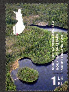
Nuuksio National Park, with a small simplified map of Finland.
Stamp issued on 06.05.2013.
1st Class (not face value).
Design: Teemu Ollikainen.
Printed by Joh. Enschedé Stamps, Haarlem, Netherlands.
Printing: Offset lithography.
Print: 4,000,000 copies.
Size: 34.5 x 24.5 mm.

Catalogs
- AFA No. 2263.
- LaPe Finland No. 2220.
- Michel No. 2237.
- Scott No. 1429.
- StampWorld No. 2249.
- Stanley Gibbons No. 2155.
- Yvert et Tellier No. 2204.

Nuuksio National Park (Finnish: Nuuksion kansallispuisto; Swedish: Noux nationalpark) was established in 1994. The park spreads over an area of forests and lakes in Espoo, Kirkkonummi and Vihti, in Uusimaa County. The name is derived from the Nuuksio district of Espoo. It has an area of 53 km2 (20 sq mi). The area is home to dozens of endangered or near-threatened animal, plant and fungal species, for example, the Siberian flying squirrel, the European nightjar and the lark; there are also virgin forests, peat bogs and traditional biotopes, especially meadows. At its highest point, the area reaches 110 m (361 ft) above sea level.

14/08/2021

ANDORRA


ANDORRA (French Post).

Llorts Mine.
Stamp issued on 23.04.1990.
Face value: 3.20 French francs.
Design and engraving: Claude Durrens (1921-2002).
Printing: Recess.
Print: 170,358 copies.

Catalogs
- AFA No. 411.
- Edifil No. 407.
- Michel No. 408.
- Scott No. 390.
- StampWorld No. 410.
- Stanley Gibbons No. 426.
- Yvert et Tellier No. 386.

This iron mine is located in the town of Llorts (179 inhabitants in 2017), located at an altitude of 1,430 m (4,690 ft), in the parish of Ordino. It was exploited from the seventeenth century to the end of the nineteenth century. The extracted mineral served to feed the forges and ironworks of Ordino and other parishes of Andorra. In addition to iron ore, pyrite was mined. In 2003 the mine was declared an archaeological zone and included in the cultural heritage of Andorra. The current small mine dates from the 19th century and can be visited.

13/08/2021

FAROE ISLANDS


FAROE ISLANDS / FØROYAR.

Hestur Island coast and Buygdin village.
Last stamp in a set of 5, issued on 07.09.1987.
Face value: 550 Faroese oyra.
Design: Ole Wich (b. 1953).
Engraved by Czesław Słania (1921-2005).
Printing: Offset lithography and recess.
Print: 426,000 copies.
Size: 31 x 41 mm.

Catalogs
- AFA No. 152.
- Michel No. 158.
- Scott No. 165.
- StampWorld No. 152.
- Stanley Gibbons No. 153.
- Yvert et Tellier No. 152.

Hestur (in Danish, Hestø) is one of the 18 islands that make up the Faroe archipelago, in the North Atlantic. Its area is 6.1 km2 (2.4 sq mi) and its maximum elevation is in the Eggjarrók and Múlin mountains, both of 421 m (1,381 ft). The oldest Viking settlement, from the High Middle Ages, was Hælur, at the southern tip of the island. The school in the town of Hestur, on the east coast, was built in 1890 and the church in 1910; in 1913, the Bygdin pier was also established in its vicinity. Since January 1, 2005, the entire island is part of the municipality of Tórshavn, the largest in the archipelago. The total stable population of the island is about 40 inhabitants. On the west coast is a guillemot colony. In the north there is moorland with four small lakes, of which Fagradalsvatn is the largest.

UZBEKISTAN


UZBEKISTAN / O'ZBEKISTON.

25th anniversary of the Kitab State Geological Reserve.
Stamp issued on 01.12.2004 (with an attached label).
Face value: 100 Uzbekistani som.
Printing: Offset lithography.
Print: 20,000 copies.
Size: 60 x 42 mm.

Catalogs
- Michel No. 556.
- Scott No. 404.
- StampWorld No. 563.
- Stanley Gibbons No. 478.

The Kitab Reserve lies on the southwestern spurs of the Zarafshan Range (part of the Pamir-Alay mountains), in the Qashqadaryo region (East Uzbekistan), near Tadjikistan border, on the left bank of the Jindidarya River. It was created in 1979. The area occupied by the reserve is 39.38 km2 (15.20 sq mi). For 120-140 million years in the area of the Kitab Geological Reserve a warm sea basin had been. Therefore, the main sights are paleontological and stratigraphical sections. These are the objects where one can observe the sequence of formation of rocks and study the fossils of ancient organic forms preserved in them. The Khojakurgan valley (in the stamp) is not only one of the modern episodes of wildlife, but also the recorded in stone the life story spanning more than 140 million years of Paleozoic time.

12/08/2021

JAMAICA


JAMAICA.

Definitive stamps
Priestman's River, Portland (and portrait of King George VI).
Twelfth stamp in a set of 18, issued on 10.12.1938.
Face value: 6 Jamaican penny.
Printing: Recess.
Size: 34 x 28 mm.

Catalogs
- Michel No. 129A.
- Scott No. 123a.
- StampWorld No. 132.
- Stanley Gibbons No. 128.
- Yvert et Tellier No. 130.

Priestman's River is located in the northeast of Jamaica. It has its sources in the Blue Mountains, runs through the Portland Parish and empties into the Long Bay coast (Caribbean Sea). Its banks, in the final stretch, are very populated.

-
Thanks to Dragan Buškulić for his contribution (https://worldofstamp2.wordpress.com/).

10/08/2021

FRANCE


FRANCE.

Landscapes.
Seine Valley at Les Andelys (Normandy).
Second stamp in a set of 6, issued on 05.06.1954.
Face value: 6 French francs.
Design: Albert Decaris (1901-1988).
Engraving: Pierre Munier (1889-1962).
Print: 116,610,000 copies.
Size: 40 x 26 mm.

Catalogs
- AFA No. 1015.
- Michel No. 1005.
- Scott No. 720.
- StampWorld No. 998.
- Stanley Gibbons No. 1206.
- Yvert et Tellier No. 977.

The Seine is a 775-kilometre-long (482 mi) river in northern France. Its drainage basin is in the Paris Basin (a geological relative lowland) covering most of northern France. It rises at Source-Seine, 30 km (19 mi) northwest of Dijon in northeastern France in the Langres plateau, flowing through Paris and into the English Channel at Le Havre (and Honfleur on the left bank). It is navigable by ocean-going vessels as far as Rouen, 120 km (75 mi) from the sea. The name Seine comes from Gaullish Sēquana, from the Celtic Gallo-Roman goddess of the river, offerings for her were found at the source.

Les Andelys is a commune in the northern French department of Eure, in Normandy. Its population, in January 2018, was 8,092 inhabitants.

09/08/2021

CUBA


CUBA.

Conference of Solidarity of the Peoples of Latin America, and portrait of Fabricio Ojeda.
Map of Central and South America.
Second stamp in a set of 4, issued on 28.07.1967.
Face value: 13 cents of Cuban peso.
Printing: Offset lithography.
Size: 30 x 42 mm.

Catalogs
- Michel No. 1318.
- Scott No. 1248.
- StampWorld No. 1319.
- Stanley Gibbons No. 1500.
- Yvert et Tellier No. 1129.

From July 31 to August 10, 1967, the first Conference of the Latin American Solidarity Organization (Organización Latinoamericana de Solidaridad, OLAS) took place in Havana. Its objectives were to achieve the unity of the revolutionary forces that participated in the struggle to achieve liberation, independence and national sovereignty of the peoples against imperialism. More than 40 countries participated in the Conference, and the term Latinoamérica was used for the first time, in contrast to the pan-Americanism promoted by the United States since the unilateral enunciation of the Monroe Doctrine in 1823.

Fabricio Ojeda (1929-1966) was a Venezuelan journalist, politician, and guerrilla. He fought clandestinely against the dictatorship of Marcos Pérez Jiménez and in the attempts to overthrow President Rómulo Betancourt and, after their failure, founded a guerrilla front of the Armed Forces of National Liberation (Fuerzas Armadas de Liberación Nacional, FALN), of which he he was commander. On June 17, 1966 he was arrested by the Information Service of the Armed Forces of Venezuela and imprisoned. On June 21 he was found hanged in his cell and it was assumed that he had committed suicide, but it was always suspected that he had been murdered.

08/08/2021

COLOMBIA


COLOMBIA.

Colombian postage stamps centenary,
Map of Colombia with postal routes and old stamp.
Special delivery mail. Last stamp in a set on 8, issued on 01.12.1959.
Facial value: 10 cents of Colombian peso.
Design: Imre Mosdóssy (1904-1995).
Printed by Staadtsdruckerei, Wien.
Printing: Photogravure.
Print: 5,000,000 copies.
Size: 25 x 40 mm.

Catalogs
- Leo Temprano No. 956.
- Michel No. 891.
- Scott No. C354.
- StampWorld No. 873.
- Stanley Gibbons No. 996.
- Yvert et Tellier No. PA 344.

The first Colombian postage stamp was issued on September 1, 1859. It had as its central image and in green the Coat of Arms of the Granadine Confederation (Confederación Granadina). It was the first value of a set of three. On this stamp is represented the second value of the set, in its violet variety.
The map shows the existing postal routes in the country in 1859.

07/08/2021

LIHOU


LIHOU (Guernsey).

Lihou Youth Project.
Map of the Lihou Island.
Second stamp in a set of 5. issued on 18.07.1966.
Face value: 2 penny.
Cindarella stamp, not recognized by the UPU or considered in official catalogs.

Lihou is a small 0.15 km2 (0.057 sq mi) island located off the west coast of the island of Guernsey, between Great Britain and France. Administratively it is part of the parish of St. Peter in the Bailiwick of Guernsey, and is now owned by the Guernsey parliament, although it has had several owners in the past. Since 2006, the island has been jointly managed by the Guernsey Department of the Environment and the Lihou Charitable Trust. At low tide it is linked to the L'Erée promontory in Guernsey by a 400 m (1,300 ft) stone causeway. In 1989 the island was identified as a Site of Nature Conservation Interest and as part of an Important Bird Area that includes parts of the Guernsey coastline. From 1966 to 1969, when the Guernsey states assumed responsibility for postal services in the Bailiwick. Lihou issued his own stamps, which are philatelicly considered cindarellas with no postage value.

-
Thanks to R. Gómez-Val for his contribution.

06/08/2021

COSTA RICA


COSTA RICA.

Columbus Day.
16th century map of Costa Rica.
Stamp issued in 26.10.1987.
Face value: 30 Costa Rican colones.
Printed by Casa Gráfica Ltd, San José.
Printing: Offset lithography.

Catalogs
- Michel No. 1338.
- Scott No. 392.
- StampWorld No. 1338.
- Stanley Gibbons No. 1463.
- Yvert et Tellier No. 491.

Christopher Columbus reached the Atlantic coast of Costa Rica on September 25, 1502, on his fourth voyage. According to his diaries, there was a lot of gold in the territory, which prompted the adventurers to undertake other explorations and served as a pole of attraction for the colonizers. The initial expeditions of Diego de Nicuesa and Alonso de Ojeda on the Atlantic coast were followed by that of Vasco Núñez de Balboa, who reached the Pacific Ocean in 1513 after crossing the Isthmus of Panama. Other conquerors followed. In 1562, Juan Vázquez de Coronado toured the entire Costa Rican territory and was appointed mayor of Costa Rica and Nueva Cartago. Vázquez de Coronado is known as the true conqueror of Costa Rica for the pacifying role that he played alongside the indigenous people, gaining their trust and support. Costa Rica was since 1574 the southernmost dependency of the Captaincy General of Guatemala, part of the Viceroyalty of New Spain, a situation in which it remained until its Independence from the Spanish Empire (September 15, 1821).

-
Thanks to Dragan Buškulić for his contribution (https://worldofstamp2.wordpress.com/).

05/08/2021

NETHERLANDS


NETHERLANDS / NEDERLAND.

500th Anniversary of the Central Administration of Friesland.
Map of Friesland Province in 1498.
Stamp issued on 09.06.1998.
Face value: 80 cents of Dutch guilder.
Printing: Offset lithography.
Size: 37 x 26 mm.

Catalogs
- AFA No. 1662.
- Michel No. 1660.
- NVPH No. 1767.
- Scott No. 998.
- StampWorld No. 1660.
- Stanley Gibbons No. 1885.
- Yvert et Tellier No. 1633.

Friesland (Friesian: Fryslân) is one of the twelve provinces that make up the Kingdom of the Netherlands. It occupies the western part of the historical region of Friesland. The capital is Leeuwarden (Friesian: Ljouwert). After centuries of wars and internal conflicts, during the Middle Ages Friesland achieved what is historically called “Friese Freedom”. In 1498 the region was submitted to Albert III, Duke of Saxony, governor of the Habsburg Netherlands, who established a central administration. Only in 1648, by the Peace of Münster, Friesland became a full member of the independent Dutch Republic, a federation of provinces.

04/08/2021

KYRGYZSTAN


KYRGYZSTAN / КЫРГЫЗСТАН.

Sary-Chelek Nature Reserve and pheasant (Phasianus colchicus).
Stamp issued on 04.02.1992.
Face value: 15 Russian kopek.
Desing: Yuri Artsimenev (1937-2019).
Printing: Offset lithography.
Print: 2,500,000 copies.
Size: 40 x 28 mm.

Catalogs
- Michel No. 1.
- Scott No. 1.
- StampWorld No. 1.
- Stanley Gibbons No. 1.
- Unificato No. 1.
- Yvert et Tellier No. 3.

The Sary-Chelek Nature Reserve (Kirghiz: Сары-Челек биочөйрөлүк коругу) is located in Jalal-Abad Region (western Kyrgyzstan). The Reserve, at altitudes from 1,200 to 4,250 m (3,940 to13,940 ft) above sea level, was established in 1959, and in 1978 it was designated as a World Biosphere reserve by UNESCO. The reserve currently occupies 238.68 km² (92.15 sq mi); in this central part there are seven lakes, the largest of which is the Sary-Chelek. To the north, east and west, the reserve is bounded by the Chatkal mountain range, in the Tian Shan Mountains, and its foothills, and in the south it is adjacent to the Fergana Valley. Among the fauna, rich in birds, there are rare animal species: the red wolf, the mountain ram, the Himalayan brown bear and the snow leopard, as well as bison, deer and fallow deer, as well as reaclimatized pheasants and partridges.

03/08/2021

SLOVENIA


SLOVENIA / SLOVENIJA.

Golica Mountain.
Stamp issued on 23.03.1999.
Face value: 15 Slovenian tolar.
Design: StudioBotas, Ljubljana.
Printed by Delo tiskarna, Ljubljana.
Printing: Offset lithography.
Print: 300,000 copies.
Size: 40.32 x 28.8 mm.

Catalogs
- AFA No. 273.
- Michel No. 255.
- Scott No. 345.
- Slovenika No. 255,
- StampWorld No. 255.
- Stanley Gibbons No. 402.
- Yvert et Tellier No. 235.

Golica Mountain (German: Kahlkogel) is a 1,835 m (6,020 ft) peak in the western Karawanks, in the Alps, on the border between Slovenia and Austria, above the Slovenian town of Jesenice. It is known primarily for its fields of wild white daffodils (depicted on the stamp). 250 m (820 ft) below the summit, at an altitude of 1,582 m (5,190 ft), there is a mountain refuge.

-
Thanks to Giovanna Goric for his contribution.

HUNGARY


HUNGARY / MAGYAROSZÁG.

Afforestation of the One Millionth Hectare.
Simplified map of Hungary with the wooded areas, aspen and oak leaves, and pine branches. 
Stamp issued on 14.12.1976.
Face value: 1 Hungarian forint.
Design: Vertel József (1922-1993).
Printing: Offset lithography.
Print: 4,259,000 copies.
Size: 36 x 46 mm.

Catalogs
- AFA No. 3082.
- Michel No. 3170A.
- Philatelia Hungarica No. 3155,
- Scott No. 2450.
- StampWorld No. 3193.
- Stanley Gibbons No. 3076.
- Yvert et Tellier No. 2530.

02/08/2021

ESTONIA


ESTONIA / EESTI.

Lahemaa National Park.
Stamp issued on 15.09.2001.
Face value: 4.40 Estonian kroon.
Photo: A. Ader / V. Lillemets.
Printing: Offset lithography.
Print: 300,000 copies.
Size: 27.5 x 33 mm.

Catalogs
- AFA No. 444.
- Michel No. 415.
- Scott No. 423.
- StampWorld No. 450.
- Stanley Gibbons No. 407.
- Yvert et Tellier No. 401.

Lahemaa National Park (Estonian: Lahemaa rahvuspark) is located in northern Estonia, about 50 km (31 mi) east from Tallinn. The Gulf of Finland (Baltic Sea) is to the north of the park. Its area covers 747 km2 (including 274.9 km2 of sea). It was established on June 1, 1971, and it was the first area to be designated a national park of the former Soviet Union. It is the largest park in Estonia and one of Europe's biggest national parks. It comprises four large peninsulas (Juminda, Pärispea, Käsmu and Vergi) separated from each other by four bays (Kolga, Hara, Eru and Käsmu). With forests covering more than 70% of the park, the area is rich in flora and fauna. The landscape has many elevated swamps.

UNITED ARAB REPUBLIC (UAR) - Egypt


UNITED ARAB REPUBLIC (UAR) - Egypt.

Definitive stamps.
Sadd el-Ali Dam in the Nile River, Aswan.
Fifth stamp in a set of 12, issued on 01.01.1964.
Face value: 5 milliemes of Egyptian pound.
Printing: Photogravure.
Size: 30 x 25 mm.

Catalogs
- Michel No. 721b.
- Scott No. 604a,
- StampWorld No. 193.
- Stanley Gibbons No. 773.
- Yvert et Tellier No. 582.

The Aswan Dam, or more specifically since the 1960s, the Aswan High Dam, is the largest embankment dam in the world, which was built on the course of the Nile River in Aswan Governorate. It was built between 1960 and 1970. The dam became a key government target after the Egyptian Revolution of 1952 and has had a significant effect on Egypt's economy and culture. The dimensions of the work are: 111 m (364 ft) high, 3,830 m (12,570 ft) long, and 980 m (3,220 ft) wide at the base. The reservoir, called Lake Nasser, is 500 km (310 miles) long and 35 km (22 miles) at its widest, covering an area of 5,250 km2 (2,030 square miles). A part of the lake is located on the territory of Sudan, where it is called Lake Nubia. Lake Nasser flooded much of lower Nubia and between 100,000 and 120,000 people were resettled in Sudan and Egypt. 22 monuments and architectural complexes that were threatened by the lake, including the temples of Abu Simbel, were preserved by moving them to the banks as part of the UNESCO Nubia Campaign. The Egyptian countryside benefited from the Dam through improved irrigation and electrification. The Aswan Dam was designed by the Moscow-based Hydroproject Institute.