30/04/2022

NEPAL


NEPAL / नेपाल

Tourism.
Triveni pilgrimage site in Khaptad National Park.
Second stamp in a set of 3, issued on 30.12.1983.
Face value: 2.20 Nepalese rupee.
Design: M. N. Rana.
Printing: Offset lithography.
Print: 2,000,000 copies.
Size: 36 x 26 mm.

Catalogs
- Michel No. 436.
- Scott No. 418.
- StampWorld No. 432.
- Stanley Gibbons No. 440.
- Yvert et Tellier No. 406.

The Triveni pilgrimage site is located into the Khaptad National Park, a protected area in the Far-Western Province, established in 1984 on the advice of Khaptad Baba, a philosopher, physician, scientist, and astrologer who moved to the area in the 1940s to meditate and worship; he it spent 50 years as a hermit in Triveni and was a renowned spiritual saint. Triveni is now a religious site for Hindu pilgrims especially July and August full moon day. The park covers an area of 225 km2 (87 sq mi) and ranges in elevation from 1,400 m (4,600 ft) to 3,300 m (10,800 ft).

27/04/2022

TURKEY


TURKEY / TÜRKİYE.

Definitive stamps.
Sakarya Gorge.
Fourth stamp in a set of 14, issued in 1926.
Face value: 2 Turkish 
kuruş.
Printed by Bradbury Wilkinson Co., London.
Printing: Recess.

Catalogs
- Michel No. 846.
- Scott No. 637.
- StampWorld No. 887.
- Stanley Gibbons No. 1024.
- Yvert et Tellier No. 698.

(Place not geographically located. Any information will be appreciated.)

Thanks to Dragan Buškulić for his contribution (https://worldofstamp2.wordpress.com/).

26/04/2022

KIRIBATI


KIRIBATI.

Islands of Kiribati.
Map of Banaba Island.
Last stamp in a set of 4, issued on 14.02.1984.
Face value: 50 cents of Kiribati dollar.
Printing: Offset lithography.

Catalogs
- Michel No. 438.
- Scott No. 439.
- StampWorld No. 117.
- Stanley Gibbons No. 218.
- Yvert et Tellier No. 117.

Republic of Kiribati (in Gilbertese, Ribaberiki Kiribati) is an independent island nation in the central Pacific Ocean. It comprises 32 atolls and one raised coral island, Banaba. Its total land area is 811 km2 (313 sq mi) and the islands are dispersed over 3.5 million km2 (1.4 million sq mi) on both sides of the equator. The permanent population is over 119,000 (2020). Kiribati gained its independence from the United Kingdom on July 12, 1979. The capital, South Tarawa, is the most populated area in the country and consists of several islets, connected by a long road. Kiribati is a member of the Pacific Community, the Commonwealth of Nations, the IMF and the World Bank, the Pacific Islands Forum, the Alliance of Small Island States, and a full member of the United Nations since 1999. Before its independence it was called the Gilbert Islands, in honor of Thomas Gilbert, who sighted some of the islands in 1788.

Banaba (also known as Ocean Island) is a solitary raised coral island west of the Gilbert Island chain, it is the westernmost point of Kiribati, lying 298 km (185 mi) east of Nauru, which is also its nearest neighbour. It has an area of 6.29 km2 (2.43 sq mi) and the highest point on the island is also the highest point in Kiribati, at 81 metres (266 ft). The population, in 2020, was 330. Along with Nauru and Makatea (French Polynesia), it is one of the important elevated phosphate-rich islands of the Pacific. The first European to sight the island was the American captain Jared Gardner, of the ship Diana, on January 3, 1801. During the Japanese occupation (February-August 1942), much of the population was killed, and the center of the island was mined.

25/04/2022

NORWAY


NORWAY / NORGE - NOREG.

Centenary of the municipality of Jølster.
Jølster, on the shores of Lake Jølstravatnet.
Third stamp in a set of 3, issued on 20.04.1938.
Face value: 30 Norwegian øre.
Design: Kolbjørn Finstad.
Printed by Emil Moestue A/S, Oslo.
Printing: Photogravure.
Print: 3,161,000 copies.
Size: 40 x 24 mm.

Catalogs
- AFA No. 198.
- Michel No. 197.
- Norgeskatalogen No. 219.
- Scott No. 183.
- StampWorld No. 198.
- Stanley Gibbons No. 261.
- Yvert et Tellier No. 189.

Jølster is a former municipality in Sogn og Fjordane county, established on January 1, 1838. It was located in the traditional district of Sunnfjord, on the shores of a clear green lake named Jølstravatnet. The administrative center was the village of Skei. Agriculture was the largest industry in the municipality. The main attraction in Jølster was the scenery, with easy access to the glaciers Grovabreen, Jostedalsbreen (the largest glacier in continental Europe), and Myklebustbreen. At the time of its dissolution in 2020, the municipality had an area of 671 km2 (259 sq mi) and its population was 3,047.

24/04/2022

SOVIET UNION


SOVIET UNION / СОЮЗ СОВЕТСКИХ СОЦИАЛИСТИЧЕСКИХ РЕСПУБЛИК.

Antarctic Drift of "Mikhail Somov".
Antarctica map.
Souvenir sheet issued on 10.10.1986.
Face value: 50 Soviet kopek.
Design: Aleksandr Kernosov.
Printing: Offset lithography.
Print: 800,000 copies.
Size: 70 x 90 mm.

Catalogs
- AFA No. 
- Michel No. BL189.
- Scott No. 5498.
- StampWorld No. 5445.
- Stanley Gibbons No. MS5695.
- Yvert et Tellier No. BF188.
- Zagorski No. BL192.

The “Mikhail Somov” (‘Михаил Сомов’) is a Research/Survey Vessel of 138 m (453 ft) length, built in 1975 in Kherson Shipyard (Ukraine, Soviet Union), now sailing under the flag of Russia. It is based in Arkhangelsk. On March 15, 1985, during the supply operations of the Soviet Russkaya Antarctic Station, the ship was trapped in the ice 120 km (394 mi) from the coast, and it did not get out of that situation until July 26. The stamp commemorates that fact.

23/04/2022

ICELAND


ICELAND / ÍSLAND.

EUROPA C.E.P.T. Issue.
Kirkjufell from Ófærufoss.
Second stamp in a set of 2, issued on 02.05.1977.
Face value: 85 Icelandic króna.
Printing: Photogravure.
Print: 1,500,000 copies.
Size: 26 x 36 mm.

Catalogs
- AFA No. 524.
- Michel No. 523.
- Scott No. 499.
- StampWorld No. 524.
- Stanley Gibbons No. 554.
- Yvert et Tellier No. 476.

Kirkjufell (‘Church Mountain’) is a 463 m (1,519 ft) high mountain on the north coast of the Snæfellsnes peninsula, near the town of Grundarfjörður, in western Iceland. It belongs to the Lýsuskarð volcanic system. Kirkjufell contains volcanic rock, but is not a volcano. It is a former nunatak, a mountain that protruded above the glaciers surrounding it during the Ice Age, and before that was part of what was once the area's strata. This strata is composed of alternating layers of Pleistocene lava and sandstone, with tuff at its summit.

22/04/2022

AUSTRALIA


AUSTRALIA.

National Parks.
Uluṟu-Kata Tjuṯa National Park.
Second stamp in a set of 7, issued on 06.04.1979.
Face value: 20 cents of Australian dollar.
Design: Max Robinson (1934-2018).
Printed by Asher and Co., Melbourne.
Printing: Offset lithography.
Size: 38 x 27 mm.

Catalogs
- Brusden-White No. 838.
- Michel No. 674.
- Scott No. 701.
- Seven Seas Stamps No. 726.
- StampWorld No. 673.
- Stanley Gibbons No. 709.
- Unificato No. 714.
- Yvert et Tellier No. 656.

Uluṟu-Kata Tjuṯa National Park is a protected area in the Northern Territory of Australia. The park is home to both Uluṟu / Ayers Rock and Kata Tjuṯa / Mount Olga. It covers 1,326 km2 (512 sq mi). The location is listed as a UNESCO World Heritage Site for natural and cultural landscape. Uluṟu / Ayers Rock is recognised as "Australia's most natural icon" and has become a focal point for Australia and the world's acknowledgement of Australian indigenous culture. Aṉangu are the traditional Aboriginal owners of the Park. They believe that their culture was created at the beginning of time by ancestral beings. The domed rock formations are composed of conglomerate, a sedimentary rock consisting of cobbles and boulders of varying rock types including granite and basalt, cemented by a matrix of sandstone. The crevasses are due to erosion. The Ayers Rock National Park was recognised in 1950.

20/04/2022

ETHIOPIA


ETHIOPIA / ኢትዮጵያ

Landscapes.
Lake Tana and portrait of Emperor Haile Selassie I.
Stamp issued on 10.02.1951.
Face value: 60 cents of Ethiopian birr.
Printing: Recess.
Size: 42 x 27 mm.

Catalogs
- Michel No. 291.
- Scott No. 292A.
- StampWorld No. 357.
- Stanley Gibbons No. 373a.
- Yvert et Tellier No. 289.

Lake Tana (Amharic: ጣና ሐይቅ) is the largest lake in Ethiopia and the source of the Blue Nile. Located in Amhara Region in the north-western Ethiopian Highlands, the lake is approximately 84 km (52 mi) long and 66 km (41 mi) wide, with a maximum depth of 15 m (49 ft), and an elevation of 1,788 m (5,866 ft). Lake Tana is fed by the Gilgel Abay, Reb and Gumara rivers. Its surface area ranges from 3,000 to 3,500 km(1,200 to 1,400 sq mi), depending on season and rainfall. The lake level has been regulated since the construction of the control weir where the lake discharges into the Blue Nile. This controls the flow to the Blue Nile Falls (Tis Abbai) and hydro-power station. In 2015, the Lake Tana region was nominated as a UNESCO Biosphere Reserve. Lake Tana was formed by volcanic activity, blocking the course of inflowing rivers in the early Pleistocene epoch, about 5 million years ago.

Haile Selassie I (Ge'ez: ቀዳማዊ ኃይለ ሥላሴ), born Tafari Makonnen (23 July 1892 – 27 August 1975), was Emperor of Ethiopia from 1930 to 1974.

-
Thanks to Daniel Mathieu for his contribution (http://lettresdumonde.blogspot.com/)

18/04/2022

VENEZUELA


VENEZUELA.

Tourism.
Playa Colorada.
First stamp in a set of 6, issued on 24.01.1969.
Face value: 0.15 Venezuelan bolívares.
Printed by Bundesdruckerei, Berlin.
Printing: Offset lithography.
Print: 500,000 copies.
Size: 39 x 30 mm.

Catalogs
- Michel No. 1771.
- Scott No. 930.
- StampWorld No. 1791.
- Stanley Gibbons No. 2059.
- Yvert et Tellier No. 772.

Playa Colorada is a beach on the Caribbean Sea, located in the Mochima National Park in the state of Sucre. It owes its name to the color of its sand, which has shades ranging from reddish to gold. It is characterized by its crystal clear waters, its coconut palms and its rich fauna, formed mainly by seabirds and dolphins. It is approximately 400 m (1,310 ft) long. It is under the responsibility of the Instituto Nacional de Parques (National Institute of Parks).

17/04/2022

UNITED STATES


UNITED STATES.

National Parks Centennial.
Cape Hatteras National Seashore.
Stamps issued on 05.04.1972.
Face value: 4 x 2 cents of US dollar.
Printing: Recess.
Print: 43,000,000 copies.

Catalogs
- Michel No. 1062-1065.
- Scott No. 1451a.
- StampWorld No. 1221-1224.
- Stanley Gibbons No. 1451-1454.
- Yvert et Tellier No. 948-951.

Cape Hatteras National Seashore preserves the portion of the Outer Banks of North Carolina from Bodie Island to Ocracoke Island, stretching over 110 km (70 mi), and is managed by the National Park Service. It was established on January 12, 1953. Tiene una superficie de 122.83 km2 (30,351 acres). Three visitor centers offer information about the Cape Hatteras National Seashore: the Bodie Island Visitor Center, located in the north, adjacent to the Bodie Island Lighthouse, which is open for tours seasonally; the Hatteras Island Visitor Center and Museum of the Sea, located in the Cape Hatteras Light keeper's quarters, in Buxton; and the Ocracoke Island Visitor Center, located in Ocracoke, near the Ocracoke Lighthouse.

-
Thanks to Dragan Buškulić for his contribution (https://worldofstamp2.wordpress.com/).

16/04/2022

GEORGIA


GEORGIA / საქართველო

EUROPA Issue.
Batsara-Babaneury Protected Areas.
First stamp in a set of 2, issued on 28.04.1999.
Face value: A (no face value).
Design: B. Koblianidze.
Printing: Offset lithography.
Print: 180,000 copies.
Size: 28.5 x 42 mm.

Catalogs
- Michel No. 312.
- Scott No. 210.
- StampWorld No. 308.
- Stanley Gibbons No. 299.
- Yvert et Tellier No. 224.

Batsara-Babaneuri Protected Areas is located in Kakheti, on territory of Akhmeta municipality. It was created in 2003 and includes Batsara-Babaneuri Nature Reserve and Ilto Managed Reserve.
- Batsara State Nature Reserve was first created in 1935. It is located in Pankisi Gorge; namely, in river Batsara Gorge at the right tributary of river Alazani, at an altitude of 700-2,000 m (2,295-6.560 ft) above sea level. In the middle part of Batsara gorge there are remains of tertiary relict dendroflora, almost 270 ha stands of yew forests. Such size of yew stand cannot be found anywhere in the world.
- Babanauri Nature Reserve was established relatively late, in 1961. It is located in eastern part of the Caucasus Mountain, near village lower Alvani, Babaneuri and Laliskure. Area is located at an altitude of 380-1,100 m (1,246-3,610 ft). The purpose of creation was to protect up to 240 ha zelkova stands, which is part of the Red List of Georgia.
- Ilto Managed Reserve includes the parts of the head of Ilto Valley, which extends up to 900-2000 m (2,950-6,560 ft). It borders Batsara Nature Reserve to the east. The purpose of establishment is to protect and restore precious wood species and characteristic fauna. Such birds as buzzard, hawk, sparrow-hawk, eagle and even bearded vulture rarely occur in the managed reserve; and the mammal species like hedgehogs, martens, rabbits, badgers, jackals, foxes, wolves, wild boar, bear, deer, lynx and chamois. 

15/04/2022

NEPAL


NEPAL / नेपाल

Tourism.
Trishuli River.
First stamp in a set of 3, issued on 15.09.1978.
Face value: 15 Nepalese paisa.
Design: Kancha Kumar Karmacharya (b. 1938).
Printed by 
Brüder Rosenbaum, Wien.
Printing: Offset lithography.
Print: 3,000,000 copies.
Size: 36.2 x 26mm.

Catalogs
- Michel No. 362.
- Scott No. 347.
- StampWorld No. 358.
- Stanley Gibbons No. 365.
- Yvert et Tellier No. 334.

The Trishuli River (Nepali: त्रिशूली नदी) is one of the major tributaries of the Narayani River, in the Ganges fluvial system. It originates in Tibet as a stream and enters Nepal at Gyirong Town. It is formed by melting snow from Mount Ganesh and Langtang Himal and flows along the western boundary of Langtang National Park. It is approximately 200 km (125 mi) long. Its name derives from trishula, the trident of the god Shiva. Rafting in Trisuli is one of the most popular outdoor activities in Nepal.

14/04/2022

FRANCE


FRANCE.

Tourism.
Somme Bay.
Stamp issued on 27.06.1998.
Face value: 3 French francs.
Design: Jean-Paul Véret-Lemarinier (1944-2021).
Printed by ITVF, Boulazac.
Printing: Photogravure.
Print: 9,473,425 copies.
Size: 31 x 41 mm.

Catalogs
- AFA No. 3400.
- Michel No. 3307.
- Scott No. 2645.
- StampWorld No. 3290.
- Stanley Gibbons No. 3488.
- Unificato No. 3147.
- Yvert et Tellier No. 3168.

The Somme Bay (French: Baie de Somme) is a large estuary, with the appearance of an arm of the sea, in the Picardy, in the región of Hauts-de-France. The bay drains six rivers into the English Channel, mainly the River Somme, and covers a total area of 72 km2 (28 sq mi). The bay is noted for its ornithological richness, as well as being a major tourist attraction. When the tide is out, the Baie is characterized by wide, flat areas of marsh and sand, from which glasswort (locally: salicornes) are collected. Small ponds, dug into the marshes and filled with fake plastic ducks, are used to attract migratory birds for hunting. As the tide rises the bay fills, during which time numerous working, leisure and tourist boats cross between the surrounding villages. In 1994 it was declared a National Nature Reserve (Réserve naturelle nationale de la baie de Somme). In addition to the ornithologic fauna, the presence of seals must be highlighted.

13/04/2022

LIBYA


LIBYA / ليبيا

Inauguration of the Zueitina Oil Terminal.
Illustrated map of northern Libya.
Second stamp in a set of 2, issued on 23.04.1968.
Face value: 60 millieme.
Design: A. Rahuma.
Printing: Offset lithography.

Catalogs
- Michel No. 257.
- Scott No. 339.
- StampWorld No. 262.
- Stanley Gibbons No. 417.
- Yvert et Tellier No. 325.

Zueitina or Zuwetina (الزويتينة) Terminal is a large camp situated on an arid plain next to the town of the same name, in the Al Wahat District of the Cyrenaica, at the Eastern end of the Gulf of Sidra on the coast of the Mediterranean Sea. It was inaugurated in 1968 and its oil port is used to export crude oil.

12/04/2022

NICARAGUA


NICARAGUA.

Landscapes.
Asososca Lagoon and location map.
Airmail. Fourth stamp in a set of 8, issued on 27.02.1979.
Face value: 90 cents of Nicaraguan córdoba.
Printing: Offset lithography.
Size: 47 x 29 mm.

Catalogs
- Michel No. 2068.
- Scott No. C957.
- StampWorld No. 2123.
- Stanley Gibbons No. 2196.
- Yvert et Tellier No. PA921.

The Asososca Lagoon, located west of the urban center of Managua and 2.2 km (1.37 mi) from Lake Xolotlán, occupies the bottom of an ancient crater formed by the explosion and collapse of the volcano of the same name approximately 5,000 years ago. Its surface is 1.2 km2 (0.46 sq mi), and its average depth is 95 m (312 ft). It is a natural reservoir that supplies water to a part of the city of Managua. It has been declared a protected area and nature reserve.

11/04/2022

DOMINICAN REPUBLIC


DOMINICAL REPUBLIC / REPÚBLICA DOMINICANA.

Francisco del Rosario Sánchez Bridge over the Ozama River.
Stamp issued on 12.07.1974.
Face value: 6 Dominican centavos.
Printing: Offset lithography.

Catalogs
- Michel No. 1062.
- Scott No. 724.
- StampWorld No. 1072.
- Stanley Gibbons No. 191. (?)
- Yvert et Tellier No. 748.

The Francisco del Rosario Sánchez Bridge, over the Ozama River, in the city of Santo Domingo (where it joins San Vicente de Paúl Avenue, in the Los Mina sector, with Padre Castellanos Avenue, in Los Guandules), was inaugurated in 1974. Its construction was carried out by the Venezuelan company Industrias Metalúrgicas Van Dam. It is a structure of about 800 m (2,625 ft) in length, with four lanes, two in each direction.

10/04/2022

BRITISH VIRGIN ISLANDS


BRITISH VIRGIN ISLANDS.

Eleventh Meeting of the Organization of Eastern Caribbean States.
Flag and map of Montserrat Island.
First stamp in a set of 8, issued on 28.05.1987.
Face value: 10 United States cents.
Printing: Offset lithography.

Catalogs
- Michel No. 590.
- Scott No. 577.
- StampWorld No. 590.
- Stanley Gibbons No. 630.
- Yvert et Tellier No. 567.

The Organisation of Eastern Caribbean States (OECS; French: Organisation des États de la Caraïbe orientale, OECO) is an inter-governmental organisation dedicated to economic harmonisation and integration, protection of human and legal rights, and the encouragement of good governance between countries and territories in the Eastern Caribbean. It also performs the role of spreading responsibility and liability in the event of natural disaster. The administrative body of the OECS is the Commission, which is based in Castries, the capital of Saint Lucia. The OECS was created on 18 June 1981, with the Treaty of Basseterre, which was named after the capital city of St. Kitts and Nevis. The members of the Organization are: Antigua and Barbuda, Dominica, Grenada, Montserrat, Saint Kitts and Nevis, Saint Lucia, and Saint Vincent and the Grenadines. The associate members are: Anguilla, British Virgin Islands, Guadeloupe and Martinique.

09/04/2022

GERMAN DEMOCRATIC REPUBLIC


GERMAN DEMOCRATIC REPUBLIC / DEUTSCHE DEMOKRATISCHE REPUBLIK.

Protected landscapes.
Königsstuhl Cliff.
Second stamp in a set of 6, issued on 17.05.1966.
Face value: 15 East German pfennig.
Design: Gerhard Wilhelm August Stauf (1924-1996).
Printed by 
Deutsche Wertpapierdruckerei (VEB), Leipzig.
Printing: Offset lithography.
Print: 5,000,000 copies.
Size: 43 x 26 mm.

Catalogs
- Michel No. 1180.
- Scott No. 832.
- StampWorld No. 922.
- Stanley Gibbons No. E898.
- Yvert et Tellier No. 881.

Königsstuhl is a chalk cliff in Jasmund National Park on the Baltic Sea island of Rügen. It lies at 118 m (387 ft) above sea level. In 2004 it was incorporated into the terrain of Königsstuhl National Park Centre. There is a legend that the name Königsstuhl ("King's Chair") goes back to an event in 1715 when the Swedish king Charles XII is supposed to have commanded a sea battle against the Danes from this spot. The battle tired the ruler so much that he needed to take a chair. However, the name Königsstuhl was used in a travel report by the vicar Rhenan in 1586, who had been tasked by the Pomeranian duke to find mineral springs; thus it is clear that it had been named much earlier.

08/04/2022

YUGOSLAVIA (Montenegro)


YUGOSLAVIA (Montenegro) / JUGOSLAVIJA (Црна Гора - Crna Gora).

Airmail definitive stamps.
Bay of Kotor (Бока которска
Boka kotorska).
Sixth stamp in a set of 9, issued on 16.06.1951.
Face value: 20 Yugoslav dinar.
Design: Design: Janez Trpin (1908-1973).
Engraving: Kocmut.
Printed by ZIN.
Printing: Recess.
Size: 39 x 24 mm.

Catalogs
- AFA No. 640.
- Michel No. 649A.
- Scott No. C39.
- StampWorld No. 681.
- Stanley Gibbons No. 680.
- Yvert et Tellier No. PA37.

The Bay of Kotor (Montenegrin: Бока которска / Boka kotorska), also known as the Boka, is a winding bay of the Adriatic Sea in southwestern Montenegro. The bay is about 28 kilometres (17 mi) long with a shoreline extending 107.3 kilometres (66.7 mi). It is surrounded by two massifs of the Dinaric Alps: the Orjen mountains to the west (highest point is the Orjen Peak, 1,894 m, 6,214 ft), and the Lovćen mountains to the east. The bay is composed of several smaller broad bays, united by narrower channels. The bay inlet was formerly a river system. Its well-preserved medieval towns of Kotor, Risan, Tivat, Perast, Prčanj and Herceg Novi, along with their natural surroundings, are major tourist attractions. The Natural and Culturo-Historical Region of Kotor was designated a UNESCO World Heritage Site in 1979.

-
Thanks to Dragan Buškulić for his contribution (https://worldofstamp2.wordpress.com/).

07/04/2022

UNITED NATIONS (Geneva)


UNITED NATIONS (Geneva) / NATIONS UNIES (Genève).

Solidarity with Namibia.
Simplified map of Namibia.
Stamp issued on 05.10.1979.
Face value: 1.10 Swiss franc.
Design: Eliezer Weishoff (אליעזר ויסהוף; b. 1938).
Printed by Ashton Potter (USA) Ltd.
Printing: Offset lithography.
Print: 1,229,830 copies.
Size: 26 x 36 mm.

Catalogs
- Michel No. 85.
- Scott No. 86.
- StampWorld No. 87.
- Stanley Gibbons No. 86.
- Unificato No. 85.
- Yvert et Tellier No. 85.
- Zumstein No. 86.

Namibia, officially the Republic of Namibia, is a country in Southern Africa. Namibia gained independence from South Africa on March 21, 1990, following the Namibian War of Independence. Part of the territory of present-day Namibia became an integral part of the new Union of South Africa at its creation in 1910. In 1884, the German Empire established rule over most of the territory, forming a colony known as German South West Africa. In 1920, after the end of World War I, the League of Nations mandated administration of the colony to South Africa. As Mandatory power, South Africa imposed its laws, including racial classifications and rules. Since 1948, with the National Party elected to power, this included South Africa applying apartheid to what was then known as South West Africa. The name of the country is derived from the Namib desert, the oldest desert in the world.

06/04/2022

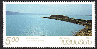
ARMENIA


ARMENIA / ՀԱՅԱՍՏԱՆ.

Landscapes.
Lake Sevan.
Fourth stamp in a set of 5, issued on 24.05.1993.
Face value: 5 Armenian rubles.
Design: Haroutiun Samuelian (b. 1947).
Printed by House of Questa.
Printing: Offset lithography.
Print: 100,000 copies.
Size: 62.5 x 32 mm.

Catalogs
- Michel No. 218.
- Scott No. 455.
- StampWorld No. 244.
- Stanley Gibbons No. 271.
- Unificato No. 195.
- Yvert et Tellier No. 192.

Lake Sevan (Armenian: Սևանա լիճ) is the largest body of water in both Armenia and the Caucasus region. Situated in Gegharkunik Province, at 1,900.44 m (6,235 ft) above sea level, it is one of the largest freshwater high-altitude in Eurasia. The total surface area of its basin is about 5,000 km2 (1,900 sq mi). Its maximum length is 74 km (46 mi). Sevan was heavily exploited for irrigation of the Ararat plain and hydroelectric power generation during the Soviet period; consequently, its water level decreased by around 20 m (66 ft) and its volume reduced by more than 40%. Later two tunnels were built to divert water from highland rivers, which halted its decline and its level began rising. Sevan originated during the early Quaternary when a Palaeo-Sevan, ten times larger than the present lake, came into existence by tectonic formation. The current lake was formed some 25 to 30 thousand years ago.

05/04/2022

NEW ZEALAND


NEW ZEALAND.

Definitive stamps.
Sutherland Falls.
Tenth stamp in a set of 12, issued on 01.09.1960.
Face value: 5 New Zealand shilling.
Printing: Photogravure.
Size: 25 x 41 mm.

Catalogs
- Michel No. 410.
- Scott No. 350.
- StampWorld No. 426.
- Stanley Gibbons No. 800.
- Yvert et Tellier No. 399.

Sutherland Falls is a waterfall near Milford Sound in New Zealand's South Island. At 580 m (1,904 ft): were long believed to be the tallest waterfall in New Zealand, but Terror Falls, in the Poseidon Valley, are 750 m, and Browne Falls cascades 843 m leading some to view that as the tallest. The water of Sutherland falls from Lake Quill in three cascades: the upper is 229 m tall, the middle is 248 m, and the lower is 103 m tall. Sutherland Falls was first known to Europeans when a Scottish settler, Donald Sutherland, saw them in 1880.

04/04/2022

POLAND


POLAND / POLSKA.

Mountains and plants in Tatra National Park.
Świnica Mountain.
Third stamp in a set of 6, issued on 05.09.1996.
Face value: 55 Polish grosz.
Design: Jacek Brodowski.
Printed by PWPW (Polska Wytwórnia Papierów Wartościowych), Warszawa.
Printing: Offset lithography.
Print: 1,000,000 copies.
Size: 43 x 31 mm.

Catalogs
- AFA No. 3513.
- Fischer No. 3472.
- Michel No. 3620.
- Scott No. 3315.
- StampWorld No. 3626.
- Stanley Gibbons No. 3648.
- Yvert et Tellier No. 3407.

Świnica (Slovak: Svinica) is a mountain in the main crest of the High Tatras, on the Polish-Slovak border, with two peaks whose altitude differs by about 10 m (33 ft), separated by the pass named Świnicka Szczerbina Niżnia (2,279 m, 7,477 ft). The main peak is at 2,302 m (7,752 ft) above sea level and is located about 10 km (6 mi) as the crow flies from Zakopane. The first ascent to the highest peak, after several unsuccessful attempts, was made on July 22, 1867 by Polish climbers Maciej Sieczka, Eugeniusz Janota, Bronisław Gustawicz and Stanisław Librowski. Świnica is one of the most visited Tatra peaks by mountaineers today. The flower depicted on the stamp is a Clusius' gentian (Gentina clusii).

Thanks to Krystyna Betiuk for his contribution (https://pocztowkowezbiory.blogspot.com/)

03/04/2022

LATVIA


LATVIA / LATVIJA.

EUROPA issue.
Gauja National Park.
Second stamp in a set of 2, issued on 20.03.1999.
Face value: 60 Latvian santims.
Printing: Offset lithography.
Print: 200,000 copies.
Size: 33 x 28.5 mm.

Catalogs
- AFA No. 500.
- Michel No. 497.
- Scott No. 485.
- StampWorld No. 467.
- Stanley Gibbons No. 519.
- Yvert et Tellier No. 465.

Gauja National Park (Latvian: Gaujas nacionālais parks), in Vidzeme, is the largest national park in Latvia, with an area of 917.86 km2 (35,439 sq mi) running from north-east of Sigulda to south-west of Cēsis along the valley of the Gauja River, from which it takes its name. It was established in 1973 in order to protect slightly disturbed natural areas, promote nature tourism and ensure sustainable development in the area. In the national park, there are over 500 monuments of history and culture – hillforts, stone castles, churches, manors, water and windmills, as well as other archaeological, architectural and art monuments.

02/04/2022

LEBANON


LEBANON / لُبْنَان

Landscapes.
Tabarja.
Third stamp in a set of 5, issued on 29.07.1966.
Face value: 2.50 Lebanese piastre.
Printing: Photogravure.
Size: 34 x 27 mm.

Catalogs
- Michel No. 948.
- Scott No. 445.
- StampWorld No. 946.
- Stanley Gibbons No. 920.
- Yvert et Tellier No. 261.

Tabarja (Arabic: طبرجا) is an ancient coastal village situated in Kesrouan district, on the shores of the Mediterranean Sea, about 28 km (17 mi) north of Beirut. The main attraction of the town is its fishing port, where Saint Paul is said to have set sail on one of his missionary trips to Europe. The town has a long historical past, and there are remains of the Greek, Roman and Byzantine civilizations, the Crusades and the Ottoman Empire. It is currently a tourist and summer resort. Tabarja suffered severely from the effects of the Lebanese Civil War.