Showing posts with label - Dams. Show all posts

15/11/2022

GERMANY


GERMANY / DEUTSCHLAND.

Centenary of Möhne Reservoir.
The Möhne Dam.
Stamp issued on 04.04.2013.
Face value: 90 Euro cents.
Design: Gerda M. Neumann and Horst F. Neumann.
Printed by Giesecke+Devrient, München.
Printing: Offset lithography.
Size: 44.2 x 26.2 mm.

Catalogs
- AFA No. 3842.
- Michel No. 3000.
- Scott No. 2730.
- StampWorld No. 2771.
- Stanley Gibbons No. 3843.
- Unificato No. 2832.
- Yvert et Tellier No. 2821.

The Möhne Reservoir is an artificial lake in North Rhine-Westphalia German State, some 45 km (28 mi) east of Dortmund. The lake is formed by the damming of two rivers, Möhne and Heve, and with its four basins stores as much as 135 million cubic meters of water. The 650 m (2,132.5 ft) dam was built between 1908 and 1913, and when it opened it was the longest in Europe. This water complex was conceived to help control flooding, regulate water levels in the Ruhr River, and generate hydroelectric power. The dam was bombed by RAF during Operation Chastise on the night of May 16/17, 1943: a 77m by 22m breach was opened and the ensuing massive flood wave killed more than 1,570 people. Lake Möhne is designated as a European bird sanctuary in the Natura 2000 system of protected areas of the European Union.

07/11/2022

IRAN


IRAN / ایران

Definitive stamps.
Farahnaz Dam and 
Mohammad Reza Shah Pahlavi.
Third stamp in a set of 11, issued on 01.09.1974.
Face value: 50 Iranian dinar.
Printing: Photogravure.

Catalogs
- Michel No. 1740.
- Scott No. 1822.
- StampWorld No. 1741.
- Stanley Gibbons No. 1898.
- Yvert et Tellier No. 1611.

Farahnaz Dam, now know as Latiyan Dam (Persian: سد لتيان), built for the Tehran Regional Water Board between 1963 and 1967, is a concrete max gravity structure located in a maximum height of 107 m (351 ft) and a crest length of nearly 360 m (1,181 ft). It is located 25 km (15.5 mi) north-est of Tehran, in the south of city of Lavasan, in the course of the Jajrud River, southern part of central Alborz mountain range. Associated with the dam are a hydro-electric peak power station.

05/10/2022

LUXEMBOURG


LUXEMBOURG / LËTZEBUERG.

Opening of the Moselle River Canal System. Lock at the Gréewemaacher-Wellen Dam.
Stamp issued on 26.05.1964.
Face value: 3 
Luxembourgish francs.
Design: Robert Cami (1900-1975).
Printed by Imprimerie des Timbres-Poste et des Valeurs Fiduciaires, Paris.
Printing: Recess.
Print: 1,200,000 copies.
Size: 40 x 26.1 mm.

Catalogs
- AFA No. 692.
- Michel No. 696.
- Scott No. 410.
- StampWorld No. 697.
- Stanley Gibbons No. 743.
- Yvert et Tellier No. 647.

The principle of the channeling of the Moselle was definitively acquired when on October 27, 1956 the plenipotentiaries of the three riparian States, France, Germany and Luxembourg, signed the international convention on the development of the river. The Contracting States have decided to develop the Moselle between Koblenz (Germany) and Thionville (France) to make these 270 km (168 mi) of waterways accessible to boats of 1,500 tons. On May 26, 1964, the canalized Moselle was officially opened to navigation.

The Gréewemaacher-Wellen Dam (French: Barrage-écluse de Grevenmacher) is situated at kilometer 212.85 of the canal between the Luxembourg town of Gréewemaacher and the German town of Wellen. The lock for large ships is 170 m (558 ft) long and 12 m (39.3 ft) wide, with a drop height of 6.25 m (20.5 ft).

Thanks to Dragan Buškulić for his contribution (https://worldofstamp2.wordpress.com/).

30/09/2022

IRAQ


IRAQ / العراق

Hydroelectric Dam in the Taksim Tharthar-Euphrates Canal.
Official stamp issued in 08.1978.
Face value: 5 Iraqi fils.
Printing: Photogravure.

Catalogs
- Michel No. D364.
- Scott No. O332.
- Stanley Gibbons No. O1338.
- Yvert et Tellier No. S286.

The Tharthar or Altharthar, known in Iraq as Buhayrat ath-Tharthar (Arabic: بحيرة الثرثار), is an artificial lake opened in 1956, situated northwest of Saladin Governorate and south of the city of Samarra, about 90 km (56 mi) northwest of Baghdad, between the Tigris and the Euphrates rivers. The lake has an artificial outlet built in 1956 called Taksim Tharthar Canal, which drains to the Euphrates River directly. The canal, after 28 km (17.4 mi) from its outlet, forks to another canal that returns water back to the Tigris River. The dam, with six gates, built in 1976, serves to regulate the outflow of water from the lake and, at the same time, to produce electricity.

07/09/2022

GHANA


GHANA.

Kpong Hydro-Electric Project.
Kpong Dam in construction.
First stamp in a set of 4, issued on 28.06.1982.
Face value: 20 Ghanaian pesewa.
Design: C. Tetteh.
Printed by Questa Colour Security Printers Ltd.
Printing: Offset lithography.
Size: 43 x 29 mm.

Catalogs
- Michel No. 938.
- Scott No. 801.
- StampWorld No. 934.
- Stanley Gibbons No. 998.
- Yvert et Tellier No. 750.

The Kpong Dam, also known as the Akuse Dam, is a hydroelectric power generating dam on the lower Volta River near Akuse. It was constructed between 1977 and 1982. Its power station has a capacity of 148 megawatts (198,000 hp) with all four units running, though the total nameplate capacity is 160 megawatts (210,000 hp). The dam is 240 m (790 ft) long and 18 m (59 ft) high. In addition to electricity generation, the project provides irrigation water for agriculture and water supply to Accra and its metropolitan area.

04/09/2022

INDIA


INDIA / भारत.

Definitive stamps.
Bhakra Dam.
Tenth stamp in a set of 11, issued on 15.03.1967.
Face value: 5 Indian rupee.
Printed by India Security Press, Nashik (Maharashtra).
Printing: Photogravure.
Size: 41 x 23 mm.

Catalogs
- Michel No. 399.
- Scott No. 421.
- StampWorld No. 402.
- Stanley Gibbons No. 519.
- Yvert et Tellier No. 232.

Bhakra Dam (Hindi: भाखड़ा बांध) is a concrete gravity dam on the Sutlej River in Bhakra Village near Bilaspur in Himachal Pradesh State in northern India. Its length (measured from the road above it) is 518.25 m (1,700 ft) and the width is 9.1 m (30 ft). Its height is 226 m (741 ft). Construction of the dam started in 1948 and was completed by the end of 1963. Successive stages were completed by the early 1970s. During its construction, more than 370 villages were submerged. The dam retains excess water during the monsoon and provides regulated discharge throughout the year. It also prevents damage due to monsoon flooding. Electric power is produced at the dam, and the Bhakra Canal fed by this dam provides irrigation for 10 million acres of fields (40,000 km2). The dam forms the Gobind Sagar reservoir.

29/08/2022

LAOS


LAOS / ລາວ

25th Anniversary of the Economic Commission for Asia and the Far East.
Nam Ngum Dam.
Second stamp in a set of 3, issued on 15.03.1972.
Face value: 80 Lao kip.
Design: Anoulom Souvandouane (b. 1948).
Engraving: Claude Jumelet (b. 1946).
Printed by Imprimerie des timbres-poste, Périgueux.
Printing: Recess.

Catalogs
- Michel No. 335.
- Scott No. 229.
- StampWorld No. 335.
- Stanley Gibbons No. 347.
- Yvert et Tellier No. 246.

The Nam Ngum (Laotian: ນໍ້າງືມ) Dam is a hydroelectric dam on the Nam Ngum River, a major tributary of the Mekong River in Laos. It is located about 75 km (46.6 mi) north of Vientiane. The dam was constructed in three stages, beginning in with stage I in 1968 and ending with the completion of stage III in 1984. The stage I was opened in 1971. The dam has a capacity of 155 MW and generates most of Laos' electricity, including all the power used in the capital, Vientiane; Additionally 70–80 percent of electricity created by the dam is exported to Thailand. The dam, which is also used for flood control, irrigation, is 468 m (1,535 ft) long and 70 m (230 ft) high. The reservoir formed by the dam has an area of 370 km2 (140 sq mi).

The United Nations Economic Commission for Asia and the Far East (ESCAP) was establshed in March 28, 1947 to assist in post-war economic reconstruction, and is currently headquartered in Bangkok (Thailand). It is composed of 53 Member States and nine Associate members, mostly from the Asia and Pacific regions. In addition to countries in Asia and the Pacific, the commission's members include France, the Netherlands, the United Kingdom and the United States. On August 1, 1974, the commission was renamed to the Economic and Social Commission for Asia and the Pacific.

24/08/2022

ZAIRE (Democratic Republic of Congo)


ZAIRE / ZAÏRE (Democratic Republic of Congo).

7th Anniversary of the New Regime.
Inga Dam, 1st Phase.
Last stamp in a set of 3, issued on 25.01.1973.
Face value: 0,18 Zairean zaire.
Printing: Photogravure.
Size: 43 x 33 mm.

Catalogs (Numbering of the Democratic Republic of the Congo)
- Belgium No. 825.
- Michel No. 472.
- Scott No. 792.
- StampWorld No. 469.
- Stanley Gibbons No. 813.
- Yvert et Tellier No. 831.

Republic of Zaire (French: République du Zaïre) is the name adopted by the Democratic Republic of the Congo from October 27, 1971 to August 15, 1974, following Mobutu's seizure of power in a military coup in 1965, following five years of political upheaval following independence from Belgium known as the Congo Crisis.

Inga Dam is located across the Congo River, approximately 150 km (93 mi), upstream of where the river empties into the Atlantic Ocean, at an altitude of 47 m (140 ft) above sea level. The stamp reproduces the first of the three planned dams, built between 1965 and 1971. It is 587 m (614 ft) long and its function is to produce hydroelectric power. The dam was built on the right bank of the river, taking advantage of the Nkokolo, a dry valley that used to be the riverbed, whose banks reached 150 m (492 ft) high at the level of the Inga Falls, parallel to the site. The water is withdrawn 10 km (6.21 mi) upstream of the dam, at an altitude of 125 m (410 ft).

18/08/2022

BAHAWALPUR


BAHAWALPUR / بہاول پور

Silver Jubilee of the Nawab Sadiq Mohammad Khan V.
Panjnad Dam and portrait of the Nawab.
First stamp in a set of 4, issued on 03.03.1949,
Face value: 3 Pakistani pies.
Printed byPrinted by De La Rue & Co. Ltd., Basingstoke (England).
Printing: Recess.
Size: 36 x 31 mm.

Catalogs
- Michel No. 22.
- Scott No. 22.
- StampWorld No. 22.
- Stanley Gibbons No. 39.
- Yvert et Tellier No. 18.

The Bahawalpur state (Urdu: بہاولپُور) was founded in 1609 by Nawab Bahawal Khan Abbasi. On February 22, 1833, Abbasi III entered into a subsidiary alliance with the British, by which Bahawalpur was admitted as a princely state of British India. After various vicissitudes, it remained independent until its voluntary incorporation into Pakistan on October 7, 1947, under Nawab Sadiq Muhammad Khan Abbasi V Bahadur, but remained an autonomous entity till October 14, 1955. Immediately after its accession to the Pakistani state, the Hindu and Sikh minority communities migrated to India, while Muslim refugees from India settled in the city of Bahawalpur and the region. The Royal House of Bahawalpur is said to be of Arabic origin and claims descent from Abbas ibn Abd al-Muttalib, progenitor of the Abbasid Caliphs of Baghdad and Cairo.

The Panjnad dam (Urdu: پنجند), on the river of the same name, was opened in 1929. It is located west of the city of Bahawalpur. It has three canals: Panjnad canal, Abbassia canal, and Abbassia link canal. These canals irrigate Bahawalpur and Rahim Yar Khan districts and the northern Sindh area.

06/08/2022

SLOVAKIA


SLOVAKIA / SLOVENSKO.

Technological advances.
Orava Dam and Reservoir.
Stamp issued on 21.04.2017.
Face value: 0.95 euro.
Design: Marián Komáček (b. 1959).
Engraving: František Horniak (b. 1956).
Printed by Poštovní tiskárna cenin Praha.
Printing: Photogravure and recess.
Print: 1,000,000 copies.
Size: 44.1 x 26.5 mm.

Catalogs
- AFA No. 780.
- Michel No. 815.
- POFIS No. 634.
- Scott No. 764.
- StampWorld No. 803.
- Stanley Gibbons No. 761.
- Unificato No. 815.
- Yvert et Tellier No. 714.

Orava (Slovak: Oravská priehrada) is a reservoir in northernmost Slovakia, forming the largest lake in Slovakia (35.2 km2). It was created by the construction of a dam between 1941 and 1953 on the former two sources of the Orava river. Several former villages had to be inundated for this purpose. The reservoir has two islands: Vtáčí ostrov ("Bird Island"), an ornithological reservation with Protected Bird Area status, and Slanický ostrov ("Slanica Island").

-
Thanks to Dragan Buškulić for his contribution (https://worldofstamp2.wordpress.com/).

22/07/2022

IRAN


IRAN / ایران

Shahnaz [Ekbatan] Dam Inauguration.
Second stamp in a set of 2, issued on 08.06.1963.
Face value: 14 Iranian rial.
Printing: Offset lithography.

Catalogs
- Michel No. 1161.
- Scott No. 1250.
- StampWorld No. 1160.
- Stanley Gibbons No. 1294.
- Yvert et Tellier No. 1032.

The Ekbatan Dam (Persian: سد اکباتان, known as Shahnaz before the Islamic Revolution) is located on the Abshineh River, in Hamadan province, about 10 km (6.20 mi) southeast of the city of Hamadan. It was built between 1959 and 1963 to supply drinking and agricultural water to the region. It was originally 54 m (177 ft) high, and was later added another 25 m (82 ft) due to population growth and increased water needs. The reservoir (دریاچه سد اکباتان) he created has an area of 60 hectares and a depth ranging between 18 and 32 m (59 and 105 ft). The lake is a place of passage for numerous migratory birds.

19/03/2022

DENMARK


DENMARK / DANMARK.

Danish islands.
Avernakø Island.
First stamp in a set of 4, issued on 16.03.1995.
Face value: 3.75 Danish krone.
Design: Eric Mourier (b. 1939).
Engraving: Arne Kühlmann Hansen (1939-2017). 
Printing: Recess.
Print: 25,100,000 copies.
Size: 41 x 24 mm.

Catalogs
- AFA No. 1086.
- Michel No. 1096.
- Scott No. 1022.
- StampWorld No. 1099.
- Stanley Gibbons No. 1043.
- Unificato No. 1099.
- Yvert et Tellier No. 1099.

Avernakø is an island in the south of Funen archipelago, belonging to the Association of Small Danish Islands. It has an area of 5.9 km² (2.28 sq mi) and is part of the municipality of Faaborg-Midtfyn. It is characterized by its elongated shape and strongly mountainous terrain; it has an approximate length of 8 km (5 mi) and its population, in 2021, was 110 inhabitants. It is made up of two islands, Abernak and Korshavn, which in 1937 were joined by a 700 m (2,300 ft) long dyke, called Drejet. The island arose about 15,000 years ago from the deposits left by the glacier of the last glaciation as it descended the high Scandinavian mountains. Finds of three stone dolmens and stone age tools indicate that the island was inhabited around 5,000 years ago. In 2000 the western part of Arnakø was designated a Nature reserve.

-
Thanks to Dragan Buškulić for his contribution (https://worldofstamp2.wordpress.com/).

13/03/2022

SPAIN


SPAIN / ESPAÑA.

Sciences of the Earth and the Universe.
Map of the border between Castilla-La Mancha, Castilla y Léon and Extremadura.
First stamp in a set of 2, issued on 16.02.2007.
Face value: 0.30 euro.
Printed by Real Casa de la Moneda - Fábrica Nacional de Moneda y Timbre, Madrid.
Printing: Offset lithography.
Size: 40.9 x 28.8 mm.

Catalogs
- AFA No. 4327.
- Edifil No. 4314.
- Michel No. 4205.
- Scott No. 3480.
- StampWorld No. 4213.
- Stanley Gibbons No. 4263.
- Yvert et Tellier No. 3910.

The Rosarito reservoir, which appears on the map, dams the waters of the Tiétar River and is located in the Tagus River hydrographic basin, in the central area of the Iberian Peninsula, between the provinces of Ávila (Castilla y León) and Toledo (Castilla la Mancha). It was built between 1940 and 1958 for irrigation use, and has a capacity of 82 cubic hectometers. The dam is 123.35 m (404.69 ft) long and 37.5 m (123 ft) high. The reservoir constitutes an important wintering nucleus for the common crane.

08/03/2022

VIETNAM


VIETNAM / VIỆT NAM.

Đa Nhim Hydroelectric Power Station.
Third stamp in a set of 4, issued on 15.01.1964.
Face value: 3 
South Vietnamese đồng.
Printing: Recess.

Catalogs
- Michel No. 306 (South Vietnam).
- Scott No. 229 
(South Vietnam).
- StampWorld No. 209 
(South Vietnam).
- Stanley Gibbons No. 209 
(South Vietnam).
- Yvert et Tellier No. 232 
(South Vietnam).

The Đa Nhim Hydroelectric Power Station is on the Đa Nhim River, in Lâm Đồng Province. The construction, with funding from the Japanese government, started in April 1961 and was finished in January 1964. Electricity produced here supplied the central region of Vietnam but was unable to reach the large industrial centers in Saigon and Biên Hòa, which had to rely on oil for electricity generation. The dam is located at an approximate altitude of 1,000 m (3,280 ft) above sea level, and is about 1,500 m (4,920 ft) long and 38 m (124.6 ft) high. The water volume of the reservoir is 165 million m³.

-
Thanks to Daniel Mathieu for his contribution (http://lettresdumonde.blogspot.com/)

07/03/2022

ROMANIA


ROMANIA / ROMÂNIA.

Definitive stamps. Buildings.
Vidraru Dam, Argeș.
Fifth stamp in a set of 19, issued on 15.10.1972.
Face value: 5.15 Romanian lei.
Design: Ion Dumitrana (1923-1976) & Aida Tasgian- Constantinescu.
Printing: Photogravure.
Size: 28 x 22 mm.

Catalogs
- Michel No. 3087.
- Romfilatelia No. 804d.
- Scott No. 2357.
- StampWorld No. 3046.
- Stanley Gibbons No. 3933.
- Yvert et Tellier No. 2779.

The Vidraru Dam was built between 1960 and 1966 in the course of the Argeș River, in northern Argeș County, for the production of electricity, irrigation and flood prevention. The dam’s height is 166 m (545 ft), the arch length 305 m (1,000 ft) and it can store 465 million m3 of water. The reservoir is 8.94 km2 (3.45 sq mi), its length is 10.3 km (6.4 mi), the maximum width is 2.2 km (1.4 mi) and its circumference is 28 km (17 mi). The Vidraru Hydro Power Plant has an installed capacity of 220 MW.

20/02/2022

LUXEMBOURG


LUXEMBOURG / LËTZEBUERG.

EUROPA issue.
Upper Sûre Natural Park. 
First stamp in a set of 2, issued on 17.05.1999.
Face value: 16 Luxembourgish francs.
Printed by Courvoisier.
Printing: Photogravure.
Print: 400,000 copies.
Size: 48.2 x 29 mm.

Catalogs
- Michel No. 1472.
- Scott No. 1008.
- StampWorld No. 1473.
- Stanley Gibbons No. 1499.
- Yvert et Tellier No. 1422.

The Upper Sûre Natural Park (Luxembourgish: Naturpark Uewersauer; French: Parc Naturel de la Haute-Sûre; German: Naturpark Obersauer) is located in Oesling region, north-western Luxembourg, on the border with Belgium. It has an area of 162 km² (62.55 sq mi). At the heart of the park is the Upper Sûre Lake (represented in the stamp), the largest area of water in the country. The park was created in 1999 to protect the natural environment and ecosystem. It is primarily an area of conservation and a specially protected area for wild birds.

14/02/2022

DOMINICAN REPUBLIC


DOMINICAN REPUBLIC / REPÚBLICA DOMINICANA.

Electrification Plan.
Dam on the Las Damas River.
Second stamp in a set of 3, issued on 15.09.1969.
Face value: 3 Dominican centavos.
Printing: Offset lithography.

Catalogs
- Michel No. 942.
- Scott No. 661.
- StampWorld No. 952.
- Stanley Gibbons No. 1063.
- Yvert et Tellier No. 679.

The Las Damas River dam is located 12 km (7.45 mi) from the municipality of Duvergé, in the province of Independencia, in the southwest of the Dominican Republic. It was built in the course of the Las Damas River, which rises in the Bahoruco Mountain Range, by the Dominican Electricity Corporation (Corporación Dominicana de Electricidad) with the aim of producing electricity. It was inaugurated in 1967. The dam is simple concrete gravity, and has a length of 46 m (151 ft) and a height of 14.35 m (47 ft). The storage capacity of the reservoir is 40,000 m3.

30/01/2022

INDIA


INDIA / भारत

50th Anniversary of International Commission on Large Dams.
Hirakud Dam.
Stamp issued on 29.10.1979.
Face value: 30 Indian paisa.
Printed by Security Printing Press, Nashik.
Printing: Photogravure.
Print: 3,000,000 copies.

Catalogs
- Michel No. 802.
- Scott No. 830.
- StampWorld No. 805.
- Stanley Gibbons No. 948.
- Yvert et Tellier No. 599.

Hirakud Dam is built across the Mahanadi River, about 15 km (9 mi) from Sambalpur in the state of Odisha. With a length of 4.8 km (3 mi) it is the longest dam in the world. Behind the dam extends a lake, Hirakud Reservoir, 55 km (34 mi) long; the area of the artificial lake is 743 km2 (287 sq mi). Construction of the dam began in 1947, and it was opened in 1957. Power generation along with agricultural irrigation started in 1956, achieving full potential in 1966. Water from the dam at a later stage was allocated to various industries, primarily for mineral processing and coal fired thermal power plants in Jharsuguda and Sambalpur districts.

26/01/2022

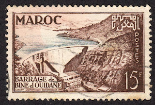
MOROCCO


MOROCCO / المغرب - ⵍⵎⵖⵔⵉⴱ

Bin el Ouidane Dam.
Second stamp in a set of 2, issued on 03.11.1953.
Face value: 15 Maroccan francs.
Design: Alexandre Delpy.
Engraving: Claude Hertenberger (1912-2002).
Printing: Recess.

Catalogs
- Michel No. 363.
- Scott No. 295.
- StampWorld No. 369.
- Stanley Gibbons No. 424a.
- Yvert et Tellier No. 329.

Bin el Ouidane (Arabic: سد بين الودان) is an arch dam on the El-Abid River, located 28 km (17 mi) south of Beni Mellal in Azilal Province. It was designed by the engineer André Coyne and constructed between 1949 and 1953. It is 133 m (436 ft) high and 290 m (950 ft) long. The purpose of the dam is hydroelectric power production and irrigation.

-
Thanks to Dragan Buškulić for his contribution (https://worldofstamp2.wordpress.com/).

31/12/2021

NEPAL


NEPAL / नेपाल

Kulekhani Dam and Indra Salobar Reservoir.
Stamp issued on 8.12.1982.
Face value: 2 Nepalese rupee.
Design: M. N. Rana.
Engraved and printed by Carl Ueberreuter Druck, Wien.
Printing: Offset lithography.
Print: 1,500,000 copies.
Size: 36 x 26 mm.

Catalogs
- Michel No. 424.
- Scott No. 406.
- StampWorld No. 420.
- Stanley Gibbons No. 428.
- Yvert et Tellier No. 394.

The Kulekhani Dam is a rock-fill dam on the Kulekhani River, in Makwanpur District of Narayani Zone. Its construction began in 1977 and ended in 1982. The dam, 114 m (374 ft) high, creates a reservoir called Indra Sarobar, with an area of 2.2 km2 (0.85 sq mi) and a length of 7 km (4.3 mi), which stores 85,300,000 m3 (69,200 acreft) of water. From the reservoir, the water is sent to the Kulekhani I hydroelectric plant through a 5.8 km (3.6 mi) inlet tunnel; the difference in elevation between the reservoir and the power station affords a net hydraulic head of 550 m (1,800 ft).