Showing posts with label MOROCCO. Show all posts

31/05/2022

SPAIN


SPAIN / ESPAÑA.

Stamp Exhibition ESPAMER 96, Seville.
Air postal line Seville-Larache 1921.
Map of southern Spain and northern Morocco with the route.
First stamp in a minisheet of 4, issued on 04.05.1996.
Face value: 100 Spanish pesetas.
Printed by F.N.M.T. (Fábrica Nacional de Moneda y Timbre), Madrid.
Printing: Photogravure.
Print: 1,200,000 copies.

Catalogs
- AFA No. 3357.
- Edifil No. 3433A.
- Michel No. 3277.
- Scott No. 2851a.
- StampWorld No. 3283.
- Yvert et Tellier No. 3011.

The Seville-Larache airline was inaugurated on October 15, 1921 with a De Havilland DH-9 plane from CETA (Compañía Española de Tráfico Aéreo [Spanish Air Traffic Company], created in 1920) piloted by the Englishman Jack Hatchett, carrying, in addition to its postal cargo , three passengers and an autograph letter from King Alfonso XIII addressed to General Emilio Barrera, greeting the Spanish troops fighting in Africa.

07/05/2022

MOROCCO


MOROCCO / المغرب - ⵍⵎⵖⵔⵉⴱ

Tourism. Landscapes and Monuments.
Estuary of the Bou Regreg.
Airmail. Second stamp in a set of 3, issued on 10.08.1955.
Face value: 200 Moroccan francs.
Design: Acelpy.
Engraving: Pierre Munier (1889-1962). 
Printing: Recess.

Catalogs
- Michel No. 406a.
- Scott No. C54.
- StampWorld No. 412.
- Stanley Gibbons No. 466.
- Yvert et Tellier No. PA101.

The Bou Regreg (Arabic: أبو رقراق) is a river located in western Morocco which discharges to the Atlantic Ocean. It is 240 km (150 mi) long, with a tidal estuary, termed Wadi Sala, of approximately 24 km (15 mi) extending upriver. The source of the river originates from the Middle Atlas mountains at an altitude of 1,627 m (5,338 ft) on the level of Jbel Mtourzgane (Province of Khemisset) and of Grou (Province of Khénifra) and descends to its mouth separating the cities of Rabat to the south and Salé to the north. The Phoenicians and the Carthaginians, who founded several colonies in Morocco, inhabited the banks of the Bou Regreg approximately two kilometers from its mouth at the ancient site of Chellah.

26/01/2022

MOROCCO


MOROCCO / المغرب - ⵍⵎⵖⵔⵉⴱ

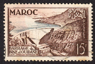
Bin el Ouidane Dam.
Second stamp in a set of 2, issued on 03.11.1953.
Face value: 15 Maroccan francs.
Design: Alexandre Delpy.
Engraving: Claude Hertenberger (1912-2002).
Printing: Recess.

Catalogs
- Michel No. 363.
- Scott No. 295.
- StampWorld No. 369.
- Stanley Gibbons No. 424a.
- Yvert et Tellier No. 329.

Bin el Ouidane (Arabic: سد بين الودان) is an arch dam on the El-Abid River, located 28 km (17 mi) south of Beni Mellal in Azilal Province. It was designed by the engineer André Coyne and constructed between 1949 and 1953. It is 133 m (436 ft) high and 290 m (950 ft) long. The purpose of the dam is hydroelectric power production and irrigation.

-
Thanks to Dragan Buškulić for his contribution (https://worldofstamp2.wordpress.com/).

19/09/2021

MOROCCO


MOROCCO / المغرب - ⵍⵎⵖⵔⵉⴱ

Unity Railroad.
With a small simplied map.
Stamp issued on 06.11.1982.
Face value: 1.40 Moroccan dirham.
Design: A. El Haimeur.
Printing: Photogravure.

Catalogs
- Michel No. 1007.
- Scott No. 540.
- StampWorld No. 1018.
- Stanley Gibbons No. 620.
- Yvert et Tellier No. 932.

Rail transport in Morocco was initially developed during the protectorate. Currently, the Moroccan railway network is about 2,200 km (1,400 mi) long and carries about 40 million passengers each year.

23/06/2021

SPANISH SAHARA


SPANISH SAHARA / SAHARA ESPAÑOL (now Western Sahara, occupied by Morocco).

Pro-Children.
Dunes in the Sahara Desert.
First stamp in a set of 2, issued on 01.06.1973.
Face value: 2 Spanish pesetas.
Printed by F.N.M.T. (Fábrica Nacional de Moneda y Timbre), Madrid.
Printing: Photogravure.
Print: 800,000 copies.
Size: 40.9 x 28.8 mm.

Catalogs
- Edifil
 No. 310.
- Michel No. 341.
- Scott No. 226.
- StampWorld No. 334.
- Stanley Gibbons No. 307.
- Yvert et Tellier No. 295.

The territory of Western Sahara was gradually colonized by Spain since 1860. The first area occupied was the Río de Oro (ادي الذهب), to the south, where in 1884 the city of Villa Cisneros (now Dakhla [الداخلة]) was founded, to which later La Güera (الكويرة‎) and Tiris (part of the Adrar territory, ولاية آدرار, which currently belongs to Mauritania) were annexed. In 1912 the annexation of Saguía el Hamra (الساقية الحمراء) region was agreed with France, where in 1938 the city of El Aaiún (العيون) was founded, which would later become the capital of the entire colony of the Spanish Sahara (الصحراء الإسبانية), relegating Villa Cisneros. The total area of ​​the colony, mostly desert, was about 280,000 km². Its definitive limits were established in the Cintra agreements (April 2, 1958).
In 1968, the Advanced Organization for the Liberation of Saguia el Hamra and Río de Oro, known simply as the Liberation Movement, was founded in the city of Smara (السمارة), which was formally constituted on December 11, 1969 with the aim of achieving the independence from Western Sahara and was outlawed by the Spanish authorities. Later, on May 10, 1973, the Polisario Front (جبهة البوليساريو) was born in Zouérate (الزويرات, Mauritania), ready to fight for independence. Morocco and Mauritania had ambitions to seize the colony, and finally on November 6, 1975 King Hassan II of Morocco organized the so-called Green March, which crossed the internationally recognized border of the Spanish Sahara (which by then had already become a semi-metropolitan province of Spain) to the north. On February 26, 1976, Spain abandoned the territory, after which the Polisario Front proclaimed the Sahrawi Arab Democratic Republic (SADR) and launched a war of liberation of the territory, which would finally be annexed to Morocco despite the reluctance of the international community and the United Nations.

24/05/2021

MOROCCO


MOROCCO / المغرب - ⵍⵎⵖⵔⵉⴱ

Al Massira Dam.
Stamp issued on 17.12.1981.
Face value: 0.60 Moroccan dirham.
Design: M. Bouaanani.
Printing: Photogravure.
Size: 40 x 28 mm.

Catalogs
- Michel No. 976.
- Scott No. 504.
- StampWorld No. 987.
- Stanley Gibbons No. 590.
- Yvert et Tellier No. 902.

The Al Massira Dam (سد المسيرة) is a gravity dam, of 82 m (269 ft) high and 390 m (1,280 ft) long, located 70 km (43 mi) south of Settat on the Oum Er-RbiaRiver, in Settat Province. Completed in 1979, the dam provides water for the irrigation of over 100,000 hectares of farmland in the Doukkala-Abda region. The dam's hydroelectric power plant, commissioned in 1980, generates 221 gigawatt-hours (800 TJ) on average annually. The 14 km2 (5.40 sq mi) reservoir is also considered an area of birdlife interest by the Ramsar Convention.

19/05/2021

TANGIER (Spanish P. O.)


TANGIER (Spanish Post Office).

Definitive stamps.
Map of the city.
Seventh stamp in a set of 14, issued on 16.02.1948.
Face value: 30 cents of Spanish peseta.
Printed by Fábrica Nacional de Moneda y Timbre, Madrid.
Printing: Recess.
Print: 200,000 copies.

Catalogs
- Edifil No. 157.
- Michel No. 132.
- Scott No. L18 (Morocco).
- StampWorld No. 166.
- Stanley Gibbons No. 132.
- Yvert et Tellier No. 371 (Morocco).

Between 1923 and 1956, by virtue of a Protocol signed by France, Spain and Great Britain, the city of Tangier (Arabic: طنجة; Tamazight: ⵜⵉⵏ ⵉⴳⴳⵉ) and its interland were, formally, an International Zone, with three postal administrations, and it remained that way until the independence of the Kingdom of Morocco (1956), although the new State did not regain sovereignty of the city until April 11, 1960. During the Second World War (1940-1945) that status was suspended, and the territory was exclusively under the sovereignty of Spain, which integrated it into its Moroccan protectorate. Tangier was characterized by the international diplomatic representations in Morocco being established there since the end of the 19th century. International administration officially began on June 1, 1925, and in subsequent years Portugal, Belgium, the Netherlands, and Italy joined the city government, although until 1940 France imposed its administrative dominance.

09/03/2021

IFNI


IFNI / إفني (Spanish colony, now in Morocco).

25th anniversary of the accession of General Franco to the Head of State, 1936-1961.
Map of the Spanish territory if Ifni.
First stamp in a set of 4, issued on 01.10.1961.
Face value: 25 cents of Spanish peseta.
Printing: Photogravure.
Issue: 240,000 copies.
Size: 25 x 41 mm.

Catalogues
- Edifil No. 179.
- Michel No. 208.
- Scott No. 99.
- StampWorld No. 178.
- Stanley Gibbons No. 177.
- Yvert et Tellier No. 153.

Ifni is a territory in southwestern Morocco, on the shores of the Atlantic Ocean, which was a colony and later a Spanish province. The extension of its territory is 1,502 km² (580 sq mi), with an estimated population of about 54,000 inhabitants. The Spanish presence in the area dates back to the 15th century, when Diego de Herrera founded, in 1476 or 1478, in a place on the coast used as a temporary base for Spanish sailors and fishermen, a slave fort called Santa Cruz de la Mar Pequeña. The Spanish were evicted by the Berbers in 1524, but Morocco recognized the right of Spain to that ancient establishment of the area through the Treaty of Was Ras signed in Tetouan on April 26, 1860, after a short war. However, the Spanish presence was non-existent until 1934, when a military garrison was established. Since Morocco gained independence in 1956, it has claimed the territory on several occasions, and after a bloody war not officially declared and a long dispute, the territory was integrated into the Kingdom of Morocco on June 30, 1969.

22/02/2021

SPANISH SAHARA


SPANISH SAHARA / SAHARA ESPAÑOL (now Western Sahara, occupied by Morocco).

25th anniversary of the accession of General Franco to the Head of State, 1936-1961.
Map of the Spanish colony of Sahara.
First stamp in a set of 4, issued on 01.10.1961.
Face value: 25 cents of Spanish peseta.
Printing: Photogravure.
Printed by F.N.M.T. (Fábrica Nacional de Moneda y Timbre), Madrid.
Print: 450,000 copies.
Size: 35 x 41 mm.

Catalogues
- Edifil No. 193.
- Michel No. 224.
- Scott No. 114.
- StampWorld No. 217.
- Stanley Gibbons No. 190.
- Yvert et Tellier No. 179.

The territory of Western Sahara was gradually colonized by Spain since 1860. The first area occupied was the Río de Oro (ادي الذهب), to the south, where in 1884 the city of Villa Cisneros (now Dakhla [الداخلة]) was founded, to which later La Güera (الكويرة‎) and Tiris (part of the Adrar territory, ولاية آدرار, which currently belongs to Mauritania) were annexed. In 1912 the annexation of Saguía el Hamra (الساقية الحمراء) region was agreed with France, where in 1938 the city of El Aaiún (العيون) was founded, which would later become the capital of the entire colony of the Spanish Sahara (الصحراء الإسبانية), relegating Villa Cisneros. The total area of ​​the colony, mostly desert, was about 280,000 km². Its definitive limits were established in the Cintra agreements (April 2, 1958).
In 1968, the Advanced Organization for the Liberation of Saguia el Hamra and Río de Oro, known simply as the Liberation Movement, was founded in the city of Smara (السمارة), which was formally constituted on December 11, 1969 with the aim of achieving the independence from Western Sahara and was outlawed by the Spanish authorities. Later, on May 10, 1973, the Polisario Front (جبهة البوليساريو) was born in Zouérate (الزويرات, Mauritania), ready to fight for independence. Morocco and Mauritania had ambitions to seize the colony, and finally on November 6, 1975 King Hassan II of Morocco organized the so-called Green March, which crossed the internationally recognized border of the Spanish Sahara (which by then had already become a semi-metropolitan province of Spain) to the north. On February 26, 1976, Spain abandoned the territory, after which the Polisario Front proclaimed the Sahrawi Arab Democratic Republic (SADR) and launched a war of liberation of the territory, which would finally be annexed to Morocco despite the reluctance of the international community and the United Nations.

25/01/2021

MOROCCO


MOROCCO / المغرب - ⵍⵎⵖⵔⵉⴱ.

Ait Aadel hydroelectric dam.
First stamp in a set of 2, issued on 03.03.1967.
Face value: 0.25 Moroccan dirham.
Design and engraving: Jean Dandine.
Printing: Recess.

Catalogues
- Michel No. 580.
- Scott No. 153
- StampWorld No. 586.
- Stanley Gibbons No. 199.
- Yvert et Tellier No. 517.

Ait Aadel hydroelectric dam, known as Moulay Youssef dam, on the course of the Tessaout River, is located about 90 km (56 mi) from the city of Marrakesh. Its capacity is 197 million m3 (6,957 M cu ft). It was designed by the French engineering company Coyne & Bellier and financed by the Soviet Union through a loan of 19.2 million US dollars. It is owned by the Office National de l'électricité (ONE). Construction work was completed in 1970, so the stamp's image is actually that of the project.