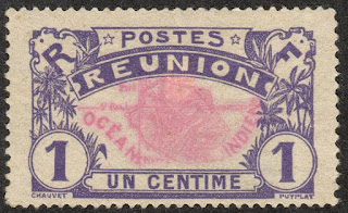
REUNION / RÉUNION.
Definitive stamps.
Map of Reunion Island.
First stamp in a set of 6, issued in 1907.
Face value: 1 cent of French franc.
Printing: Typography.
Size: 41 x 25 mm.
Catalogs
- Michel No. 56.
- Scott No. 60.
- StampWorld No. 56.
- Stanley Gibbons No. 60.
- Yvert et Tellier No. 56.
Reunion
(Reunion Creole: La Rényon) is an island of the Mascarene
archipelago with the status of a French overseas department, located in the
Indian Ocean, east of Madagascar, and constituted as an outermost region of the
European Union. Like the rest of the overseas departments, it is also a region
of France and is part of the Republic. Its area is 2,511 km2 (970 sq mi) and
its population (January 2021) was 858,450 inhabitants.
The island was occupied by the Arabs since the 10th century, but when the
Portuguese arrived in 1513, they found it uninhabited and named it Santa Apolónia.
In 1638 it was occupied by France, and it was administered from Mauritius. The
island would not be officially claimed by France until 1642, and by decree of
King Louis XIII it was
renamed Île Bourbon. Colonization, however, did not begin until 1665,
when the French
East India Company (Compagnie française pour le commerce des Indes
orientales) sent out the first settlers and African slaves. French
immigration was completed with that from Africa, China, Malaysia and India,
giving the population the diverse character it has today.
-
Thanks to Óscar Valencia for his contribution.
Thanks to Óscar Valencia for his contribution.

No comments:
Post a Comment