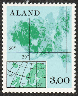
ÅLAND / AHVENANMAA.
Definitive stamps.
Map of the territory and geographic coodinates.
Second stamp in a set of 3, issued on 01.03.1984.
Face value: 3 Finnish markka.
Design: Eeva Oivo.
Printed by Finlands
Banks Sedeltryckeri.
Printing: Offset lithography.
Print: 1,500,000 copies.
Seze: 21.1 x 35.6 mm.
Catalogs
- AFA No. 5.
- LePe Finland No. 5.
- Michel No. 5.
- Scott No. 17.
- StampWorld No. 5.
- Stanley Gibbons No. 12.
- Unificato No. 5.
- Yvert et Tellier No. 5.
The Åland Islands (Finnish: Ahvenanmaa) are an archipelago and autonomous province of Finland located in the Baltic Sea, between Sweden and Finland. In 2019 the estimated population of the islands was about 19,900 inhabitants, 39% of them in the capital, Mariehamn (in Finnish: Maarianhamina). The territory of Åland is organized into 16 municipalities. The archipelago is made up of more than 6,700 islands, islets and reefs, of which only about 80 are inhabited; Fasta Åland, the main island, represents 70% of the total area of the territory. The total surface area of the landmass is 1,580 km² (610 sq mi). On June 9, 1922, Finland granted the islands a broad Statute of Autonomy in exchange for not recognizing the Swedish claims; the Statute guarantees, among other rights, the use of Swedish as the only official language: according to 2001 data, 93.5% of the population speaks it as their mother tongue. In 1954, the official use of the flag of the islands was also approved. In 1984 the archipelago obtained authorization to issue its own postage stamps and became a member of the Small European Postal Administration Cooperation (SEPAC). Since 1970 Åland has been an associate member of the Nordic Council.

No comments:
Post a Comment