14/05/2021

AUSTRIA


AUSTRIA / ÖSTERREICH.

Airplane over landscapes.
Mount Torsäule.
Airmail. Last stamp in a set of 3, issued on 05.05.1947.
Face value: 5 Austrian shilling.
Design: Heinrich Blechner (1895-1983).
Engraving: Rupert Franke (1888-1971).
Printing: Recess.
Print: 740,000 copies.
Size: 30 x 39 mm.

Catalogs
- AFA No. 713.
- ANK No. 825.
- Michel No. 827.
- Scott No. C52.
- StampWorld No. 837.
- Stanley Gibbons No. 1022.
- Yvert et Tellier No. PA 52.

Torsäule (‘gateway column’), at 2,588 m (8,591 ft) above sea level, is a very steep limestone formation, approximately 500 meters high, on the east flank of Hochkönig massif with its glacier, know as Übergossene Alm (visible on the stamp), in the Berchtesgaden Alps, in the Sankt Johann im Pongau district of the federal state of Salzburg. With more than 36 routes, the southern wall of the Torsäule is the most climbed in the Hochkönig. Its summit was first reached in 1882 by Anton von Posselt-Czorich and J. Aigner.

SINGAPORE


SINGAPORE / SINGAPURA - 新加坡共和国

Old maps.
Map of t
he Straits around Singapore.
First map in a set of 4, issued on 13.03.1996.
No face value (Local mail).
Printing: Offset lithography.

Catalogs
- Michel No. 791.
- Scott No. 747.
- StampWorld No. 809.
- Stanley Gibbons No. 828

The island of Singapore is separated, by the north, from the Malay Peninsula by the Straits of Johor, and by the south, from Indonesia, by the Singapore Strait, although there are other straits between the smaller islands that make up the country. Ancient maritime maps and charts and pilot guides presented a network of maritime channels in the area that can be seen on the stamp.

MADAGASCAR


MADAGASCAR (French Colony).

FIDES (Social and Economic Development Fund).
Canal des Pangalanes.
Third stamp in a set of 4, issued on 22.10.1956.
Face value: 10 French African CFA francs,
Design and engraving: Claude Hertenberger (1912-2002).
Printing: Recess.

Catalogs
- Michel No. 433.
- Scott No. 294.
- StampWorld No. 482.
- Stanley Gibbons No. 335.
- Yvert et Tellier No. 329.

The Canal des Pangalanes consists of a series of natural rivers, waterways and human-made lakes that extends for over 645 km (400 mi) and runs down the east coast of Madagascar from Mahavelona to Farafangana. An initial area of the canal in Toamasina is straight, while subsequent areas have curves, lagoons, connected lakes and swamps. Construction efforts began during the era of the Merina monarchy, with major expansion during the French colonial period between 1896 and 1904, and additional expansion during 1949-1957. After use of the canal decreased, a large project in the 1980s restored and renovated it.

13/05/2021

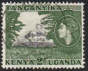
BRITISH EAST AFRICA


BRITISH EAST AFRICA (Kenya, Uganda, Tanganyika).

Definitive stamps.
Mount Kilimanjaro and Queen Elizabeth II.
Fouth stamp in a set of 7, issued on 01.06.1954.
Printing: Recess.
Face value: 2 East African shilling.
Size: 34 x 28.

Catalogs
- Michel No. 102.
- Scott No. 114.
- StampWorld No. 72.
- Stanley Gibbons No. 177.
- Yvert et Tellier No. 98.

Mount Kilimanjaro is a dormant volcano in northeastern Tanzania, near the Kenyan border. It has three volcanic cones: Shira, 4,005 m (13,140 ft); Mawenzi, 5,149 m (16,893 ft); and Kibo, with Uhuru Peak, 5,895 m (19,341 ft) at the rim of its crater. It is the highest mountain in Africa. It is integrated into the Kilimanjaro National Park and is drained by a network of streams and by the Lumi and Pangani rivers. Kilimanjaro is a major climbing destination: after numerous failed attempts by various climbers, Hans Meyer and Ludwig Purtscheller, with African guides and porters, were the first Europeans to reach the top on October 6, 1889.

-
Thanks to Dragan Buškulić for his contribution (https://worldofstamp2.wordpress.com/).

ALDERNEY


ALDERNEY.

Definitive stamps.
Location Map of Alderney.
Seventh stamp in a set of 12, issued on 14.06.1983.
Face value: 13 Guernsey penny.
Design: Gordon Drummond (1921-2001).
Printed by Courvoisier, La Chaux-de-Fonds (Switzerland).
Printing: Photogravure.
Print: 671,772 copies.
Size: 39.7 x 29 mm.

Catalogs
- AFA No. 7.
- Michel No. 7.
- Scott No. 7.
- StampWorld No. 7.
- Stanley Gibbons No. 7.
- Yvert et Tellier No. 7.

Alderney French: (Aurigny; Auregnais: Aoeur'gny) is the northernmost of the inhabited Channel Islands. It is part of the Bailiwick of Guernsey, a British Crown dependency. It is 5 km (3 mi) long and 2.4 km (1.5 mi) wide. The island's area is 8 km2 (3 sq mi), making it the third-largest island of the Channel Islands, and the second largest in the Bailiwick. It is around 15 km (10 mi) to the west of the Cotentin Peninsula, in Normandy (France), 30 km (20 mi) to the northeast of Guernsey and 100 km (60 mi) from the south coast of Great Britain. In March 2018 , the island had a population of 2019. Alderney has had its own postal administration since 1983: this stamp belongs to the first set issued.

12/05/2021

SAN MARINO


SAN MARINO.

75th Anniversary of the Universal Postal Union (UPU).
Mount Titano and mailcoach.
Stamp issued on 29.12.1949.
Face value: 100 Italian lire.
Design: Roberto Franzoni (1882-1960).
Engraving: Vittorio Nicastro (1916-?).
Printed by Istituto Poligrafico dello Stato (I.P.S.), Officina Carte-Valori, Roma.
Print: 10,000 copies.
Size: 40 x 30 mm.

Catalogs
- Michel No. 438.
- Sassone No. 366.
- Scott No. 304.
- StampWorld No. 447.
- Stanley Gibbons No. 403.
- Unificato No. 366.
- Yvert et Tellier No. 342.

The Universal Postal Union (Union postale universelle), established by the Treaty of Bern of 9 October, 1874, is a specialized agency of the United Nations that coordinates postal policies among member nations, in addition to the worldwide postal system. The UPU contains four bodies consisting of the Congress, the Council of Administration, the Postal Operations Council and the International Bureau. It also oversees the Telematics and Express Mail Service cooperatives. Each member agrees to the same terms for conducting international postal duties. The UPU's headquarters are located in Bern, Switzerland.

Mount Titano (Italian: Monte Titano) is a mountain of the Apennines and the highest peak in San Marino. It stands 739 m (2,425 ft) above sea level and is located immediately to the east of the capital, San Marino. It was inscribed as a UNESCO World Heritage Site in 2008 under the combined title "San Marino Historic Centre and Mount Titano".

-
Thanks to R. Gómez-Val for his contribution.

INDIA


INDIA / भारत.

8th Session of UN Conference on Climate Change, New Delhi.
Mangroves.
Minisheet issued on 30.10.2002.
Face value: 5 + 5 + 5 + 15 Indian rupee.
Design: K. Singh.
Printed by Calcutta Security Printers, Ltd., Kanpur.
Printing: Offset lithography.
Size: 192 x 85 mm.

Catalogs 
- Michel No. BL14.
- Scott No. 1978a.
- StampWorld No. 1927-2930.
- Stanley Gibbons No. MS2094.

The sessions took place in New Delhi between October 23 and November 1, 2002. Global warming and greenhouse gas emissions were discussed at this meeting. At the time of the meeting some 96 nations had ratified the Kyoto Protocol, but this was still not enough to bring it into effect internationally. Russia's agreement to ratify the Protocol, announced two months earlier at the Johannesburg Summit, would allow it to come into effect, finally, in late 2004. However, with the US refusing Kyoto and with many countries increasing their carbon emissions, there was no real progress in the climate negotiations at this meeting.

-
Thanks to Kumar Biswas for his contribution (https://kumar-omnibus.blogspot.com/).

PERU


PERU / PERÚ.

Definitive stamps.
Písac Inca Terraces, Cusco.
Fourth stamp in a set of 8, issued on 01.01.1966.
Face value: 0.50 Peruvian soles.
Printing: Offset lithography.
Printed by I.N.A. [Imprenta Nacional de Austria], Österreichische Staatsdruckerei, Wien.
Size: 38 x 30 mm.

Catalogs
- Bustamante No. 533.
- Michel No. 661.
- Scott No. 500.
- StampWorld No. 649.
- Stanley Gibbons No. 924.
- Yvert et Tellier No. 481.

The Písac National Archeological Park (in Quechua: P'isaq) is an important complex of the Sacred Valley of the Incas, more than 3,000 m (9,850 ft) high, located in the province of Calca, 30 km (18.65 mi) from the city of Cusco. Among the most important elements of the place are the Andenes (agricultural terraces) of Acchapata, a set of 40 terraces that were used for the cultivation of corn, which form an inverted triangle.

ITALIAN SOMALILAND


ITALIAN SOMALILAND / SOMALIA ITALIANA.

Airmail definitive stamp.
Shebelle River.
Fifth stamp in a set of 10, issued on 24.03.1950.
Face value: 90 Italian Somaliland centesimi.
Design: G. Salvini.
Printed by I.P.F., Istituto Poligrafico dello Stato, Officina Carte-Valori, Roma.
Printing: Photogravure.
Print: 593,368 copies.
Size: 40 x 24 mm.

Catalogs
- Michel No. 259.
- Sassone No. A5.
- Scott No. C21.
- StampWorld No. 249.
- Stanley Gibbons No. 248.
- Unificato No. A5.
- Yvert et Tellier No. PA 34.

Italian Somaliland (Italian: Somalia italiana; Arabic: الصومال الإيطالي‎; Somali: Dhulka Talyaaniga ee Soomaalida), was a colony of the Kingdom of Italy in present-day Somalia. Ruled in the 19th century by the Somali Sultanates of Hobyo and Majeerteen in the north, and Hiraab Imamate and Geledi in the south, the territory was acquired in the 1880s by Italy through various treaties. In 1936, the region was integrated into Italian East Africa as the Somalia Governorate. This would last until Italy's loss of the region in 1941, during the East African campaign of World War II. Italian Somalia then came under British military administration until 1950, when it became a United Nations trusteeship under Italian administration. On July 1, 1960, the Trust Territory of Somaliland united with the former British Somaliland protectorate to form the Somali Republic.

The Shebelle River (Somali: Webi Shabeelle, Arabic: نهر شبيلي, Amharic: እደላ, Italian: Uebi Scebeli), about 2,050 km (1,275 mi) long, 1,150 in Ethiopia and 900 in Somalia, begins in the highlands of Ethiopia, and then flows southeast into Somalia towards Mogadishu. Near Mogadishu, it turns sharply southwest because of the coastal dunes, and it follows the coast. South, the river becomes seasonal; during most years, the river dries up near the mouth of the Jubba River, while in seasons of heavy rainfall, the river actually reaches the Jubba and thus the Indian Ocean.

-
Thanks to Vairo Gregori for his contribution (https://ternifil.org/).

11/05/2021

ICELAND


ICELAND / ÍSLAND.

Landscapes.
Glacier Eiríksjökull.
Second stamp in a set of 3, issued on 08.05.1957.
Face value: 3 Icelandic króna.
Design: S. Jonsson.
Printed by De La Rue, London.
Printing: Recess.
Print: 1,000,000 copies.
Size: 36 x 26 mm.

Catalogs
- AFA No. 318.
- Michel No. 317.
- Scott No. 303.
- StampWorld No. 318.
- Stanley Gibbons No. 347.
- Yvert et Tellier No. 275.

Eiríksjökull is a glacier to the northwest of the great Langjökull glacier, in Iceland's Vesturland region, and has an area of 22 km2 (8.5 sq mi). Its height is 1675 m (5495 ft), making it the largest table mountain in the island. It is situated in the Hallmundarhraun lava field, on top of a 750 m (2,460 ft) thick lava shield, presumably formed by a single subglacial volcanic activity. It is the largest volcano of its kind in Iceland, and is considered dormant or extinct. The Fnjóská river is born in the glacier, which flows into the Eyjafjörður fjord.

KIRIBATI


KITIBATI.

Islands of Kiribati.
Map of Kanton Island.
Third stamp in a set of 4, issued on 14.02.1984.
Face value: 35 cents of Kiribati dollar.
Printing: Offset lithography.

Catalogs
- Michel No. 437.
- Scott No. 438.
- StampWorld No. 116.
- Stanley Gibbons No. 217.
- Yvert et Tellier No. 116.

Republic of Kiribati (in Gilbertese, Ribaberiki Kiribati) is an independent island nation in the central Pacific Ocean. It comprises 32 atolls and one raised coral island, Banaba. Its total land area is 811 km2 (313 sq mi) and the islands are dispersed over 3.5 million km2 (1.4 million sq mi) on both sides of the equator. The permanent population is over 119,000 (2020). Kiribati gained its independence from the United Kingdom on July 12, 1979. The capital, South Tarawa, is the most populated area in the country and consists of several islets, connected by a long road. Kiribati is a member of the Pacific Community, the Commonwealth of Nations, the IMF and the World Bank, the Pacific Islands Forum, the Alliance of Small Island States, and a full member of the United Nations since 1999. Before its independence it was called the Gilbert Islands, in honor of Thomas Gilbert, who sighted some of the islands in 1788.

Kanton Atoll (also known as Canton Island or Abariringa), previously known as Mary Island, Mary Balcout's Island or Swallow Island, is the largest, northernmost, and the sole inhabited island of the Phoenix Islands, in the Republic of Kiribati. The island is a narrow ribbon of land around a lagoon, an area of 40 km2 (15.44 sq mi). As of 2015, the population of the atoll was 20 people, down from 61 in 2000. The island's sole village is called Tebaronga. Kanton Island is included among the 8 Kiribati atolls declared in 2006 Phoenix Islands Protected Area, expanded in 2008. Modern Canton derives its name from the whaler Canton, which was wrecked on its outer shore in March 1854.

10/05/2021

ESTONIA


ESTONIA / EESTI.

Estonian lighthouses.
Kunda lighthouse in Kunda Bay.
Stamp issued on 12.03.1998.
Face value: 3.60 Estonian kroon.
Design: Roman Matkiewicz (b. Tallinn, 27.02.1966).
Printing: Offset lithography.
Print: 790,100 copies.
Size: 26 x 37.5 mm.

Catalogs
- AFA No. 347.
- Michel No. 322.
- Scott No. 338.
- StampWorld No. 354-
- Stanley Gibbons No. 313.
- Yvert et Tellier No. 308.

Kunda Bay (Estonian: Kunda laht) is located on the northern coast of Estonia, in the county of Lääne-Virumaa, and is part of the Gulf of Finland, in the Baltic Sea. At its center, about 100 km east of Tallinn, is the city of Kunda, which has a major port. The Kunda and Toolse rivers flow into the bay. The Kunda lighthouse, built in 1909, was at the Kunda port. It was destroyed by fire in summer1999.

ISRAEL


ISRAEL / יִשְׂרָאֵל‎ - إِسْرَائِيل

Landscapes.
Gan Ha-Shelosha National Park.
Stamp issued on 07.11.1972.
Face value: 0.05 Israeli lira.
Printing: Photogravure.
Size: 31 x 26 mm.
Catalogs

- Israel Philatelic Federation No. 574.
- Michel No. 525.
- Scott No. 462.
- StampWorld No. 524.
- Stanley Gibbons No. 494.
- Yvert et Tellier No. 459.

Gan Ha-Shlosha National Park (Hebrew: גן השלושה; Arabic: الساخنة) is located between kibbutzim Beit Alfa and Nir David, near Beit She’an. It has natural hot water, which remains constant throughout the year at a temperature of 28 ºC (82.4 ºF). The water emerges in the western part of the park, at the foot of Mount Gilboa, and the Amal stream leads it to two large interconnected pools where visitors can take a bath. The park is home to the Museum of Regional and Mediterranean Archeology, a display of rare Greek tools and artifacts from excavations in the Beit She’an Valley, and an old, restored Ottoman flour mill.

-
Thanks to Dragan Buškulić for his contribution (https://worldofstamp2.wordpress.com/).

09/05/2021

YUGOSLAVIA (Slovenia)


YUGOSLAVIA (Slovenia) / JUGOSLAVIJA (Slovenija).

200th Anniversary of the First Ascent of the Triglav.
Mount Triglav.
Stamp issued on 26.08.1978.
Face value: 2 Yugoslav dinar.
Printing: Photogravure.
Print: 894,273 copies.
Size: 28 x 33 mm.

Catalogs
- Michel No. 1740.
- Scott No. 1386.
- StampWorld No. 1774.
- Stanley Gibbons No. 1836.
- Yvert et Tellier No. 1623.

Triglav, with an elevation of 2,863.65 m (9,395.2 ft), is the highest mountain in Slovenia and the highest peak in the Julian Alps. It was also the highest peak in Yugoslavia before Slovenian independence in 1991. It is the centerpiece of Triglav National Park, Slovenia's only national park, and the preeminent symbol of the Slovenian nation. Triglav's height was first measured on September 23, 1808 by Valentin Stanič. At the top of the mountain is a small metal structure, the Aljaž Tower (Slovenian: Aljažev stolp), which acts as a storm shelter and triangulation point. Triglav's first ascent was achieved on August 26, 1778, at the initiative of industrialist and scholar Sigmund Zois. According to a report published in 1821 by the historian and geographer Johann Richter, those who reached its peak were the surgeon Lovrenz Willomitzer, the chamois hunter Štefan Rožič and the miners Luka Korošec and Matevž Kos.

-
Thanks to R. Gómez-Val for his contribution.

SPANISH GUINEA


SPANISH GUINEA / GUINEA ESPAÑOLA (now EQUATORIAL GUINEA).

Landscapes.
Benito River and portrait of general Franco.
Sixth stamp in a set of 16, issued on 01.12.1949.
Face value: 5 cents of Spanish peseta.
Printing: Photogravure.
Size: 40.4 x 24.9 mm.

Catalogs
- Edifil No. 278.
- Michel No. 243.
- Scott No. 306.
- StampWorld No. 347.
- Stanley Gibbons No. 332.
- Yvert et Tellier No. 311.

Spanish Guinea, officially Spanish Territories of the Gulf of Guinea (Spanish: Territorios Españoles del Golfo de Guinea), was an African colony of Spain located in the Gulf of Guinea. It was formed from the Río Muni Colony (established in 1900), the Fernando Poo (now Bioko) Island, the Elobey, Annobón and Corisco Colony and other adjacent islands. The colony lasted between 1885 and 1968. It was reunified in 1926, becoming Spanish Guinea (Guinea Española), which became independent forming the Republic of Equatorial Guinea, recognized by Spain on October 12, 1968.

The Benito (in Fang language: Mbini) is a river in Equatorial Guinea, 338 km (210 mi) long. It is also known locally as Wele River, and, at least as it flows in its westerly part through the Monte Alén National Park, as the Uoro River. The river rises in Gabon and crosses into Equatorial Guinea where it divides the country roughly along the middle, running east to west. At the mouth to the Atlantic Ocean lies the town of Mbini, as well as large mangrove stands that extend 20 km (12.4 mi) inland; only this portion of the river is navigable.

08/05/2021

MARSHALL ISLANDS


MARSHALL ISLANDS / AORŌKIN M̧AJEĻ

Definitive stamps.
Map of Likiep Atoll.
Second stamp in a set of 10, isued on 12.06.1984.
Face value: 3 cent of US dollar.
Printing: Offset lithography.
Size: 20 x 23 mm.

Catalogs
- Michel No. 6A.
- Scott No. 36.
- StampWorld No. 6.
- Stanley Gibbons No. 6.
- Yvert et Tellier No. 46.

The Marshall Islands, officially the Republic of the Marshall Islands (Marshallese: Aolepān Aorōkin Ṃajeḷ), is an island country and an associated state of the United States in the Pacific Ocean, north the Equator. Geographically, the country is part of Micronesia. The republic's population, of 58,413 people (2018 Census), is spread out over 29 coral atolls, comprising 1,156 islands and islets. The capital and largest city is Majuro. The total area of the landmass is 181.43 km2 (70.05 sq mi). Islands in the archipelago were first explored in the 1520s by Ferdinand Magellan and Juan Sebastián Elcano. Spain claimed the islands in 1592, and the European powers recognized its sovereignty in 1874. In 1885 Spain sold some of the islands to the German Empire. In World War I, Japan occupied the archipielago, and in 1920 the League of Nations combined with other former German territories to form the South Seas Mandate. During World War II, the United States took control of the islands. Nuclear testing began on Bikini Atoll in 1946 and concluded in 1958. In May 1, 1979 Marshall Islands proclaimed their independence, but full sovereignty or self-government was achieved in a Compact of Free Association with the United States.

Likiep is a 65-island atoll in the Pacific Ocean, and forms a legislative district of the Ratak Chain of the Marshall Islands. Its total land area is only 10.26 km2 (3.96 sq mi), but that encloses a deep central lagoon of 424 km2 (164 sq mi). Likiep Atoll also possesses the Marshall Islands' highest point, an unnamed knoll 10 m (33 ft) above sea level. The population of the atoll was 401 in 2011.

INDONESIA


INDONESIA.

National Disaster Fund.
Ijen volcanoes complex.
Last stamp in a set of 4, issued on 20.12.1967.
Face value: 5 + 0.50 Indonesian rupiah.
Printing: Photogravure.
Size: 32 x 48 mm.

Catalogs
- Michel No. 595.
- Scott No. B210.
- StampWorld No. 638.
- Stanley Gibbons No. 1181.
- Yvert et Tellier No. 528.
- Zonnebloem No. 598.

The Ijen complex is a group of compound volcanoes located east of the island of Java. It is inside a caldera, about 20 km (12 mi) wide, at the bottom of which are several villages, whose inhabitants benefit from the extraction of sulfur, one of the great economic resources of the region. Mount Merapi stratovolcano, at 2,910 m (9,550 ft), is the highest point in this complex; to the west of its summit is a 1 km (0.62 mi) diameter turquoise crater lake with extraordinarily acidic waters. Within and along the rim of the caldera is a concentration of cones and craters: the active crater of Kawah Ijen has a diameter of 722 m (2,369 ft) and a depth of 200 m (660 ft), producing a curious phenomenon known as blue lava, which are actually electric blue flames produced by sulfuric gas that emerges from the cracks, and can reach temperatures of up to 600 ° C (1,112 ° F).

-
Thanks to Vairo Gregori for his contribution (https://ternifil.org/).

SWEDEN


SWEDEN / SVERIGE.

National Parks.
Muddus National Park.
Third stamp in a set of 5, issued on 26.01.1990.
Face value: 3.70 Swedish krona.
Design: A. Gullberg.
Engraving: 
Zlatko Jakuš (b. Zagreb 1945).
Printing: Recess.
Size: 32 x 27 mm.

Catalogs
- AFA No. 1536.
- Facit No. 1601.
- Michel No. 1584.
- Scott No. 1778.
- StampWorld No. 1586.
- Stanley Gibbons No. 1488.
- Yvert et Tellier No. 1568.

The Muddus National Park (Swedish: Muddus nationalpark; Sami: Muttos) is located in the Norrbotten County, in the extreme north of Sweden. The park was established in 1942, and expanded in 1984 to cover a total of 511.37 km2 (19,744 sq mi). It is bordered to the northwest by the Stubba nature reserve, which serves as a transition to other natural areas in the Lapland region. The heart of Muddus is a vast plain just under 400 m (1,310 ft) above sea level, surrounded by a few small peaks at the limits of the park, the highest of which is Sör-Stubba, rising to 665 m (2,182 ft). In this plain an extensive network of peat bogs develops that represents almost half of the surface of the protected area. The dry sections are covered by a vast taiga forest, making Muddus the largest national forest park in the country. To the south of the park is the valley of the Lule River. There are several gorges along this stretch, notably the one formed by the park's main river, the Muttosädno, with the Muddusfallet waterfall, which falls 42 m (138 ft).

-
Thanks to Dragan Buškulić for his contribution (https://worldofstamp2.wordpress.com/).

07/05/2021

IRELAND


IRELAND / ÉIRE.

Shannon Hydroelectric Scheme.
Opening of the Ardnacrusha Dam.
Stamp issued on 15.10.1930.
Face value: 2 Irish penny.
Printing: Typography.
Print: 19,330,805 copies.
Size: 41 x 24 mm.

Catalogs
- AFA No. 55.
- Michel No. 55.
- Scott No. 83.
- StampWorld No. 59.
- Stanley Gibbons No. 92.
- Unificato No. 58.
- Yvert et Tellier No. 58.

The Shannon Hydroelectric Scheme, harnessing the power of the river's waters, was central to the development of the Irish Free State in the 1920s. Its main result was the Ardnacrusha Hydroelectric Power Station, commissioned in 1929, located in the County Clare (Irish: Contae an Chláir). Completed in the seven years following Irish independence (1922), at a cost equivalent to one-fifth of the Irish state's annual budget, the plant enabled a huge increase in electricity demand across the country. The plant was built by the German company Siemens-Schuckert, but much of the design was done by Irish engineers. The work involved major changes in the flow of the entire Shannon river with multiple dams and bridges, and the construction of a national electricity grid.

ECUADOR


ECUADOR.

75th Anniversary of the Universal Postal Union (U.P.U.).
San Pablo Lake.
Second stamp in a overprinted set of 3, issued on 11.10.1949.
Face value: 0.20 out of 0.50 Ecuadorian sucre.
Printed by Institut de Gravure, Paris.
Printing: Recess.

Catalogs
- Michel No. 726.
- Scott No. 530.
- StampWorld No. 730.
- Stanley Gibbons No. 903.
- Yvert et Tellier No. 519.

San Pablo Lake, also known as Imbacocha (in Kichwa: Impakucha), is located in the Ecuadorian province of Imbabura, in the Andes range, at an altitude of 2,660 m (8,727 ft) above sea level. Its length is 3.5 km (2.17 mi) and its width is 2.2 km (1.37 mi), covering an area of 6.7 km2 (2.58 sq mi); its maximum depth is 35 m (115 ft). Its main tributary is the Itambi River, and it is drained by the Jatunyaku (or Hatunyaku) River. The lake has great symbolic importance for the Otavalo indigenous people.