31/01/2022

RHODESIA


RHODESIA (now Zimbabwe).

Development.
Devil's Cataract, Victoria Falls.
Sixth stamp in a sef of 14, issued on 17.02.1970.
Face value: 8 cents of Rhodesian dollar.
Design: Rose Martin.
Printed by Mardon Printers, Salisbury.
Printed: Offset lithography.
Size: 30 x 27 mm.

Catalogs
- Michel No. 93.
- Scott No. 284.
- StampWorld No. 93,
- Stanley Gibbons No. 444.
- Yvert et Tellier No. 187.

Victoria Falls (in Sotho language, Mosi-oa-Tunya, "The Smoke That Thunders"; in Tonga language, Shungu Namutitima, "Boiling Water") is a waterfall on the Zambezi River located on the border between Zambia and Zimbabwe, and is one of the world's largest waterfalls due to its width of 1,708 m (5,604 ft). Devil's Cataract, on the Zimbabwe side of the Falls, is the lowest of the five Falls, with a drop of 60 m (196.85 ft). It is separated from the rest of the Falls by Boaruka Island, also known as Cataract Island.

-
Thanks to Óscar Valencia for his contribution.

30/01/2022

INDIA


INDIA / भारत

50th Anniversary of International Commission on Large Dams.
Hirakud Dam.
Stamp issued on 29.10.1979.
Face value: 30 Indian paisa.
Printed by Security Printing Press, Nashik.
Printing: Photogravure.
Print: 3,000,000 copies.

Catalogs
- Michel No. 802.
- Scott No. 830.
- StampWorld No. 805.
- Stanley Gibbons No. 948.
- Yvert et Tellier No. 599.

Hirakud Dam is built across the Mahanadi River, about 15 km (9 mi) from Sambalpur in the state of Odisha. With a length of 4.8 km (3 mi) it is the longest dam in the world. Behind the dam extends a lake, Hirakud Reservoir, 55 km (34 mi) long; the area of the artificial lake is 743 km2 (287 sq mi). Construction of the dam began in 1947, and it was opened in 1957. Power generation along with agricultural irrigation started in 1956, achieving full potential in 1966. Water from the dam at a later stage was allocated to various industries, primarily for mineral processing and coal fired thermal power plants in Jharsuguda and Sambalpur districts.

29/01/2022

GERMANY


GERMANY / DEUTSCHLAND.

Tinsdal Lighthouse.
Stamp issued on 01.07.2021.
Face value: 60 Euro cents.
Design: Team Rogger GmbH.
Printing: Offset lithography.
Size: 35 x 35 mm.

Catalogs
- Michel No. 3615.
- Scott No. 3222.
- StampWorld No. 3243.
- Yvert et Tellier No. 3394.

Opened in January 1, 1900, the Tinsdal Lighthouse (German: Leuchtturm Tinsdal) forms the Wittenbergen-Tinsdal main light line on the Elbe River in the district of Rissen (Hamburg). It is 16 m (52.49 ft) above sea level and its height is 57.5 m (188.65 ft). The tower has been electrified since 1966 and has been remotely controlled since 1979. In 1988, the light source was again replaced by dual signal lights (2 x 60 watts) with a visibility of 16 nautical miles. On March 31, 2004 it was declared a German Historical Monument.

28/01/2022

MEXICO


MEXICO / MÉXICO.

Fauna of Mexico.
Gray Whale (Eschrichtius robustus) and map of Mexico.
Second stamp in a set of 2, issued on 03.07.1982.
Face value: 4 Mexican pesos.
Design: Joana Bielschowsky de Aguirre (b. Rio de Janeiro 1950).
Artwork in gouache technique.
Printing: Photogravure.
Print: 1,000,000 copies.
Size: 48 x 40 mm.

Catalogs
- Michel No. 1829.
- Scott No. 1282.
- StampWorld No. 1860.
- Stanley Gibbons No. 1639.
- Yvert et Tellier No. 979.

The gray whale (Eschrichtius robustus), also known as the gray whale, gray back whale, Pacific gray whale, or California gray whale, is a baleen whale that migrates between feeding and breeding grounds yearly. It reaches a length of 14.9 m (49 ft), a weight of up to 41 tonnes (90,000 lb) and lives between 55 and 75 years. It is distributed in an eastern American North Pacific and an endangered western Asian North Pacific population. There is an abundance of them on the coast of Baja California Peninsula (Mexico), which appears marked in red on the stamp map.

27/01/2022

POLAND


POLAND / POLSKA.

Airplanes over landscapes.
Karkonosze Mountains.
Airmail. Fifth stamp in a set of 6, issued on 06.12.1957.
Face value: 4 złotych.
Design: Jerzy Miller (1921-1985).
Engraving: Marian Romuald Polak (?-1966).
Printed by PWPW (Polska Wytwórnia Papierów Wartościowych), Warszawa.
Printing: Photogravure and recess.
Print: 7,645,000 copies.
Size: 26 x 52 mm.

Catalogs
- AFA No. 929.
- Fischer No. 894.
- Michel No. 1039.
- Scott No. C45.
- StampWorld No. 1026.
- Stanley Gibbons No. 1039.
- Yvert et Tellier No. PA45.

Karkonosze is a mountain range located in the north of the Czech Republic and the south-west of Poland, part of the Sudetes mountain system. The Czech-Polish border, which divides the historic regions of Bohemia and Silesia, runs along the main ridge. The highest peak, Sněžka (Polish: Śnieżka), is the Czech Republic's highest point with an elevation of 1,603 m (5,259 ft). On both sides of the border, large areas of the mountains are designated national parks (the Krkonoše National Park in the Czech Republic and the Karkonosze National Park in Poland). and these together constitute a cross-border biosphere reserve under the UNESCO Man and the Biosphere Programme.

-
Thanks to Sylvester Dulewski for his contribution (https://birdsposta.blogspot.com/).

26/01/2022

MOROCCO


MOROCCO / المغرب - ⵍⵎⵖⵔⵉⴱ

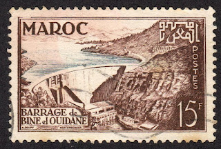
Bin el Ouidane Dam.
Second stamp in a set of 2, issued on 03.11.1953.
Face value: 15 Maroccan francs.
Design: Alexandre Delpy.
Engraving: Claude Hertenberger (1912-2002).
Printing: Recess.

Catalogs
- Michel No. 363.
- Scott No. 295.
- StampWorld No. 369.
- Stanley Gibbons No. 424a.
- Yvert et Tellier No. 329.

Bin el Ouidane (Arabic: سد بين الودان) is an arch dam on the El-Abid River, located 28 km (17 mi) south of Beni Mellal in Azilal Province. It was designed by the engineer André Coyne and constructed between 1949 and 1953. It is 133 m (436 ft) high and 290 m (950 ft) long. The purpose of the dam is hydroelectric power production and irrigation.

-
Thanks to Dragan Buškulić for his contribution (https://worldofstamp2.wordpress.com/).

25/01/2022

ICELAND


ICELAND / ÍSLAND.

Birth of Surtsey Island.
Second stamp in a set of 3, issued on 23.6.1965.
Face value: 2 Icelandic króna.
Printing: Photogravure.
Print: 1,000,000 copies.

Catalogs
- AFA No. 394.
- Michel No. 393.
- Scott No. 373.
- StampWorld No. 394.
- Stanley Gibbons No. 424.
- Yvert et Tellier No. 348.

Surtsey is a volcanic island located approximately 32 km (20 mi) off the southern coast of Iceland, integrated into the Vestmannaeyjar archipelago. It is the southernmost point of the country and was formed from a volcanic eruption that began at 130 m (427 ft) below sea level and emerged to the surface on November 14, 1963. The eruption lasted until June 5, 1967, at which time the island reached its maximum size of 2.7 km² (1.04 sq mi). Since then the erosive action of wind, water and ice have constantly reduced its size. The new island is named after Surtr, a fiery jötunn or giant from Norse mythology. Surtsey was declared a UNESCO World Heritage Site in 2008.

24/01/2022

ARGENTINA


ARGENTINA.

Argentine Provinces.
Fonck Lake, Río Negro Province.
Third stamp in a set of 4, issued on 08.10.1977.
Face value: 30 Argentine pesos ley.
Printed by Casa de Moneda, Buenos Aires.
Printing: Offset lithography.
Print: 500,000 copies.
Size: 66 x 30 mm.

Catalogs
- Cefiloza No. 1320.
- Götig and Jalil No. 1798.
- Michel No. 1315.
- Scott No. 1154.
- StampWorld No. 1338.
- Stanley Gibbons No. 1572.
- Yvert et Tellier No. 1100.

Lake Fonck, of glacial origin, is located within the Nahuel Huapi National Park, in the department of Bariloche, province of Río Negro, at an altitude of 780 m (2,559 ft). It has an area of 4.82 km2 (1.86 sq mi) and occupies a valley surrounded by the Volcánico, Fonck and Hess mountains; from its shores you can see Mount Tronador (visible on the stamp), located about 15 km (9.32 mi). It belongs to the Manso river basin. It is surrounded by Andean Patagonian forest. It owes its name to the German-Chilean explorer Francisco Fonck, who visited the region at the end of the 19th century.

22/01/2022

KAZAKHSTAN


KAZAKHSTAN / ҚАЗАҚСТАН.

Burabay National Park.
Minisheet issued on 08.12 1998.
Face value: 30 + 30 
Kazakhstani teńge.
Design: S. Marsheva.
Printing: Offset lithography.
Print: 100,000 copies.
Size: 110 x 98 mm.

Catalogs
- Michel No. BL14.
- Scott No. 257A.
- StampWorld No. 243-244.
- Stanley Gibbons No. MS243.
- Yvert et Tellier No. BF14.

The Burabay National Park (Kazakh: Бурабай мемлекеттік ұлттық табиғи паркі) is a natural park located in Aqmola Region. The first step towards the protection of this natural space has been the establishment of the State Forest in 1898. In 1935, the “National Nature Reserve of Burabay” has been organized. A governmental motion of May 6. 1997 transformed the Forest of Burabay into the “Natural and Well-being Complex of the Forest of Burabay”, managed by the State. In 2000, a motion of August 12 created the “National Nature Park of Burabay”, which includes a superficy of 83,511 ha, of which 47,600 ha of forests. In 2010, the superficy of the park has been expanded to 129,935 ha. The park counts 757 sorts of plants, and 305 species of animals can be found.

21/01/2022

BRITISH VIRGIN ISLANDS


BRITISH VIRGIN ISLANDS.

Definitive stamps.
Map of Tortola Island, and portrait of Queen Elizabeth II.
First stamp in a set of 13, issued on 01.11.1956.
Face value: 1/2 British West Indies cent.
Printed by De La Rue & Co. Ltd.
Printing: Recess.

Catalogs
- Michel No. 111.
- Scott No. 115.
- StampWorld No. 111.
- Stanley Gibbons No. 149.
- Yvert et Tellier No. 113.

Tortola is the largest and most populated of the British Virgin Islands. It is a mountainous island 19 km (12 mi) long and 5 km (3.1 mi) wide, with an area of 55.7 km2 (21.5 sq mi). Formed by volcanic activity, its highest peak is Mount Sage at 530 m (1,740 ft) above sea level. In 2010 the population of the island was 23,491 inhabitants. Christopher Columbus named the island Santa Ana. Dutch colonists called it Ter Tholen. When the British took over, the name evolved to Tortola.

19/01/2022

LATVIA


LATVIA / LATVIJA.

EUROPA issue.
Krustkalni Nature Reserve.
First stamp in a set of 2, issued on 20.03.1999.
Face value: 30 Latvian santims.
Printing: Offset lithography.
Print: 200,000 copies.
Size: 33 x 28.5 mm.

Catalogs
- AFA No. 499.
- Michel No. 496.
- Scott No. 484.
- StampWorld No. 466.
- Stanley Gibbons No. 518.
- Yvert et Tellier No. 464.

Krustkalni Nature Reserve (Latvian: Krustkalnu dadas rezervāts), founded in 1977, is located in eastern Latvia, within the Madona Municipality. Its area is 2,978 hectares. Since 2004, this institution has been part of Natura 2000, the European network of protected areas. The reserve is managed by the regional administration Latgale. It has 32 species of plants and 37 species of animals listed in the Red Book of Latvia. The territory of the Reserve is rich in lakes, rivers and springs. Among the lakes is the Dreimaņa (also known as Svētes, Latvian: Dreimaņa ezers), from which the Svetupe River flows.

18/01/2022

NORWAY


NORWAY / NORGE - NOREG.

European Nature Conservation Year.
Vøringsfossen Waterfall.
Third stamp in a set of 4, issued on 10.04.1970.
Face value: 70 Norwegian øre.
Printed by Emil Moestue trykkeri, Oslo.
Printing: Photogravure.
Print: 6,532,500 copies.
Size: 24 x 40 mm.

Catalogs
- AFA No. 617.
- Michel No. 604.
- Norgeskatalogen No. 651.
- Scott No. 553.
- StampWorld No. 620.
- Stanley Gibbons No. 646.
- Yvert et Tellier No. 560.

Vøringsfossen is a 182 m (597 ft) waterfall. It lies at the top of the Måbødalen valley in the municipality of Eidfjord, in Vestland county. The name Vøringsfossen (Old Norse: Vyrðingr) is derived from the verb vyrða (‘esteem’, ‘revere’). The last element fossen, the definite form of foss (waterfall), is a later addition. The waterfall was hardly known by anyone other than locals until 1821. 

17/01/2022

LEBANON

LEBANON / لُبْنَان

Landscapes.
Pigeons' Rocks, Beirut.
Second stamp in a set of 5, issued on 29.07.1966.
Face value: 1 Lebanese piastre.
Printing: Photogravure.
Size: 34 x 27 mm.

Catalogs
- Michel No. 947.
- Scott No. 444,
- StampWorld No. 945.
- Stanley Gibbons No. 919.
- Yvert et Tellier No. 260.

Pigeons Rocks or Raouché Rocks (Arabic: صخرة الروشة‎; French: Grotte aux Pigeons or Rochers de Raouché) is a natural site consisting of two giant limestone islets in the Mediterranean Sea, off the Beirut Corniche, which become a tourist attraction. Some geologists suppose that this rock appeared as a result of several strong earthquakes that hit the area in the 13th century, and destroyed several islands inhabited at that time; erosion has then set them to what they currently look like.

16/01/2022

TRISTAN DA CUNHA

TRISTAN DA CUNHA.

Plan of Capt. Demhan's detail (1853).
Last stamp in a set of 3, issued on 22.05.1981.
Face value: 21 British pence.
Printing: Offset lithography.

Catalogs
- Michel No. 302.
- Scott No. 292.
- StampWorld No. 301.
- Stanley Gibbons No. 306.
- Yvert et Tellier No. 290.

Vice Admiral Henry Mangles Denham (August 28, 1800 - July 3, 1887) was a Royal Navy officer. On July 30, 1845, he was made commander of HMS Avon, surveying the west coast of Africa. Between 1864 and 1866, he served as Commander-in-Chief of the Pacific Station. Specialized in hydrographic work, he drew several maps, including that of the island of Tristan da Cunha: the stamp shows a fragment corresponding to the Settlement, founded in 1816 in the northwest of the island and called, in 1867, Edinburgh of the Seven Seas (regarded as the most remote permanent settlement on Earth).

15/01/2022

ANTIGUA


ANTIGUA.

Landscapes.
English Harbour (Falmouth Bay) and portrait of Queen Elizabeth II.
Second stamp in a set of 15, issued on 02.06.1953.
Face value: 1 West Indies cent.
Printed by Waterlow & Sons Ltd.
Printing: Recess.

Catalogs
- Michel No. 102.
- Scott No. 108.
- StampWorld No. 102.
- Stanley Gibbons No. 121.
- Yvert et Tellier No. 104.

English Harbour is a natural deep-water harbor and settlement in the Saint Paul Parish, on Falmouth Bay, on the south coast of the island of Antigua. It is part of Nelson's Dockyard National Park. Its population, in 2012, was 666 inhabitants. Due to its strategic importance, it served as a base of operations for the former British Navy in the 17th and 18th centuries. It is currently a center for water sports, mainly sailing.

14/01/2022

GEORGIA


GEORGIA / საქართველო

EUROPA Issue.
Lagodekhy Reserve.
Second stamp in a set of 2, issued on 28.04.1999.
Face value: B (no face value).
Design: B. Koblianidze.
Printed: Offset lithography.
Print: 180,000 copies.
Size: 28.5 x 42 mm.

Catalogs
- Michel No. 313.
- Scott No. 211.
- StampWorld No. 309.
- Stanley Gibbons No. 300.
- Yvert et Tellier No. 223.

The Lagodekhy State Reserve (Georgian: ლაგოდეხის სახელმწიფო ნაკრძალი) is located in the Kakheti district, in north-eastern Georgia on the southern slopes of the Caucasus and border with Azerbaijan and Dagestan Republic (Russian Federation). The total area of the reserve is 24,451 ha (94.41 sq mi). Lagodekhy preserves a variety of rare local flora and fauna and was originally protected in 1912 by the Imperial Russian Geographical Society at the initiative of the Polish naturalist Ludwik Młokosiewicz. The major rivers flowing through the reserve are the Ninoskhevi, Lagodekhistskali and Matsimistskali; at the higher elevations there are glacial lakes, of which the largest is the Khala-Khel, on the Russian border.

ESTONIA


ESTONIA / EESTI.

EUROPA issue.
Tolkuse Bog.
Stamp issued on 27.04.1999.
Face value: 5.50 Estonian kroon.
Photo: Mati Kose.
Design: Jaan Saar.
Printing: Offset lithography.
Print: 385,100 copies.
Size: 23 x 27.5 mm.

Catalogs
- AFA No. 370.
- Michel No. 343.
- Scott No. 360.
- StampWorld No. 376.
- Stanley Gibbons No. 332.
- Yvert et Tellier No. 334.

The Tolkuse Bog (Estonian: Tolkuse raba) is located in the rural municipality of Häädemeeste, in Pärnu county. It has an area of 55 km² (21.24 sq mi) and is divided into two parts by the Timmkanal (also known as Uusjõgi), excavated in 1856. There are 42 ponds in the middle of the bog. It is part of the Luitemaa Nature Reserve. Formerly, in the place that the bog now occupies there was a maritime bay surrounded by dunes.

12/01/2022

CHINA REPUBLIC (Taiwan)


REPUBLIC OF CHINA (Taiwan) / 中華民國 (臺灣)

Mount Qilai (奇萊山).
Second stamp in a set of 4, issued on 16.10.2004.
Face value: 5 Taiwanese new dollar.
Printing: Offset lithography.

Catalogs
- Michel No. 2998.
- Scott No. 3577.
- StampWorld No. 2991.
- Stanley Gibbons No. 3020.

Mount Qilai (Chinese: 奇萊 ) is a mountain in Xiulin Township, Hualien County, Its highest point, the Northern Peak, is 3,607 m (11,834 ft) above sea level. It is known above all for its steep slope (which has caused numerous accidents among mountaineers) and the complexity of its climate, with unpredictable fogs.

-
Thanks to Dragan Buškulić for his contribution (https://worldofstamp2.wordpress.com/).

11/01/2022

SLOVAKIA


SLOVAKIA / SLOVENSKO.

Landscapes.
Green Lake (Zelené pleso).
First stamp in a set of 5, issued on 01.08.1940.
Face value: 5 Slovak halier.
Design: Emil Belluš (1899-1979).
Printing: Photogravure.
Print: 2,400,000 copies.
Sizs: 22 x 24 mm.

Catalogs
- AFA No. 43.
- Michel No. 71YA.
- POFIS No. 47Y.
- Scott No. 45.
- StampWorld No. 79.
- Stanley Gibbons No. 40.
- Yvert et Tellier No. 39.

The Green Lake (Slovak: Zelené pleso) is a moraine lake in the Zeleného plesa Valley. It is located in the Tatra Mountains in the historic Kežmarok area in the north of the country, at an altitude of 1,545 m (5,069 ft) above sea level. It has an area of 1.7855 ha and 4.5 m (14.76 ft) deep. Its striking greenish color has given rise to various legends, incorporated into Slovak folklore. In the stamp you can view the mountain known as Čierny štít (‘Black Shield’), at 2,429 m (7,969 ft).

10/01/2022

HUNGARY


HUNGARY / MAGYARORSZÁG.

International Transportation Exhibition, Hamburg (IVA'79).
Map of the European Railroad Network.
Minisheet issued on 08.06.1979.
Face value: 20 Hungarian forint.
Design: Pál Varga.
Printing: Offset lithography.
Print: 263,765 copies.
Size: 78 x 95 mm.

Catalogs
- AFA No. A3252a.
- Michel No. BL137A.
- Philatelia Hungarica No. 3325.
- Scott No. 2580.
- StampWorld No. 3373.
- Stanley Gibbons No. MS3244.
- Yvert et Tellier No. BF141.

The International Transportation Exhibition (VAT) was a trade fair that took place in Hamburg (Germany) in 1979, in which the entire spectrum of transport technology was displayed. On the occasion of this exhibition, the Transrapid 05 magnetic levitation train was inaugurated, which took visitors to Heiligengeistfeld, which served as the fairgrounds. In addition, new locomotives and various models of electric and hybrid buses were presented.

09/01/2022

JERSEY


JERSEY.

Jersey Forteresses.
Plan of Mont Orgueil by Thomas Phillips (1680).
First stamp in a set of 4, issued on 05.02.1980.
Face value: 8 Jersey pence.
Design: T.H.O.S. Phillips.
Printed by Joh. Enschedé Stamps, Haarlem, Netherlands.
Printed: Offset lithography.
Print: 665,647 copies.
Size: 35.2 x 27.3 mm.

Catalogues
- AFA No. 206.
- Michel No. 212.
- Scott No. 222.
- StampWorld No. 206.
- Stanley Gibbons No. 222.
- Unificato No. 206.
- Yvert et Tellier No. 206.

Mont Orgueil (Jèrriais: Mount Pride or Haughty Mount) is a castle in Jersey that overlooks the harbor of Gorey, in the east of the island. The construction of the castle was undertaken following the division of the Duchy of Normandy in 1204. It was first mentioned in 1212. The castle is first called ‘Mont Orgeuil’ in an ordinance issued by Pierre de Brézé, Lord of the Isles during the occupation by the French during the War of the Roses, in 1462. Mont Orgueil has been managed as a museum site since 1929, although during the Second World War German occupation (1940-1945), the occupying forces garrisoned the castle and added modern fortifications camouflaged to blend in with existing structures.

Thomas Phillips (1635-1693) was an military engineer and topographical watercolourist, came to Ireland from England in the winter of 1685 during the reign of James II to survey and report on the principal fortified places, castles, forts, and garrisons and to draw exact designs of their present condition and estimate the cost of any necessary repairs. He had worked in the Channel Islands (1679), making maps and plans of probable landing places and of defences needed.

08/01/2022

DOMINICAN REPUBLIC


DOMINICAN REPUBLIC / REPÚBLICA DOMINICANA.

Higuamo Bridge over the Higuamo River.
Airmail stamp issued on 12.07.1974.
Face value: 10 Dominican centavos.
Printing: Offset lithography.

Catalogs
- Michel No. 1063.
- Scott No. C217.
- StampWorld No. 1073.
- Stanley Gibbons No. 1192.
- Yvert et Tellier No. PA262.

The Higuamo Bridge, over the river of the same name (represented in the stamp) was inaugurated in 1973 near the city of San Pedro de Macorís, in the southeast of the Dominican Republic. It was subsequently completely remodeled with a new 626 m (2,054 ft) long structure, which opened in January 2007.

The Higuamo River is partially navigable and empties into the Caribbean Sea, just outside San Pedro de Macorís.

07/01/2022

ECUADOR


ECUADOR.

Chimborazo Volcano.
Fifth stamp in a set of 9, issued in 1934.
Face value: 10 Ecuadorian centavos.
Printed by American Bank Note Co., New York.
Printing: Recess.
Print: 1,000,000 copies.
Size: 28 x 24 mm.

Catalogs
- Bertossa No. 356.
- Michel No. 318.
- Scott No. 324.
- StampWorld No. 320.
- Stanley Gibbons No. 496.
- Yvert et Tellier No. 307.

Chimborazo is an inactive double stratovolcano in the Cordillera Occidental range of the Andes, and it shows four summits; Whymper, Veintimilla, Politecnica, and Nicolas Martínez. Its last eruption is believed to have occurred around 550 A.D. With a peak elevation of 6,263 m (20,548 ft) above sea level, it is the highest mountain in Ecuador. Chimborazo is in the Chimborazo Province, 150 km (93 mi) south-southwest of the city of Quito. The top of the mountain is completely covered by glaciers. The English climber Edward Whymper and his Italian guides Louis Carrel and Jean-Antoine Carrel, were the first Europeans to reach the top on January 4, 1880.

06/01/2022

ROMANIA


ROMANIA / ROMÂNIA.

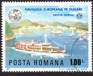
European navigation on the Danube.
"Mirceşti" ship at Orşova.
Face value: 1 Romanian leu.
Design: C. & V. Carnabatu - C. Bucur.
Printing: Photogravure.
Print: 3,000,000 copies.
Size: 55 x 42.5 mm.

Catalogs
- Michel No. 3485.
- Scott No. 2738.
- StampWorld No. 3474.
- Stanley Gibbons No. 4347.
- Yvert et Tellier No. 3079.

Orşova is a municipality in Mehedinți County, Banat. It is located on the banks of the Iron Gates I reservoir on the Danube, at the mouth of the Cerna River. In the 2011 census, its population was 10,441 inhabitants. As a result of the construction of the reservoir, the city was flooded in 1970, and the population was relocated to a completely new city built between 1966 and 1971 on the southern slopes of the Almăj Mountains. In the 2nd century AD the Romans built the Dierna fort there.

05/01/2022

SOVIET UNION


SOVIET UNION / СОЮЗ СОВЕТСКИХ СОЦИАЛИСТИЧЕСКИХ РЕСПУБЛИК.

Landscapes.
Belukha Mountain, Altai Republic
.
Seventh stamp in a set of 9, issued on 15.12.1959.
Face value: 60 Soviet kopek.
Design: S. Pomansky. 
Engraving: Ivan Sapronov.
Printing: Recess.
Print: 1,500,000 copies.
Size: 38 x 27 mm.

Catalogs
- Michel No. 2306.
- Scott No. 2278.
- StampWorld No. 2095.
- Stanley Gibbons No. 2405.
- Yvert et Tellier No. 2249.
- Zagorski No. 2302.

Belukha Mountain (Russian: Белуха; Altai: Ӱч-Сӱмер; Kazakh: Мұзтау Шыңы), located in the Katun Mountains, is the highest peak of the Altai Mountains in Russia and the highest of the system of the South Siberian Mountains. It is part of the World Heritage Site entitled Golden Mountains of Altai. Located in the Altai Republic (Russian Federation), Belukha is a three-peaked mountain massif that rises along the border of Russia and Kazakhstan. There are 169 glaciers on the mountain, including Belukha and Sapozhnikov glaciers. Of the two peaks, the eastern peak (4,506 m, 14,784 ft) is higher than the western peak (4,440 m, 14,567 ft). Belukha Mountain was first climbed in 1914 by Boris and Mikhail Tronov brothers. Lake Akkem appears in the foreground of the stamp image.

-
Thanks to Dragan Buškulić for his contribution (https://worldofstamp2.wordpress.com/).

04/01/2022

ISRAEL


ISRAEL / יִשְׂרָאֵל‎ - إِسْرَائِيل

Israel Landscapes.
Mount Hermon.
Stamp issued on 16.01.1973.
Face value: 0,45 Israeli lira.
Printing: Photogravure.
Size: 31 x 26 mm.

Catalogs
- Israel Philatelic Federation No. 576.
- Michel No. 530x.
- Scott No. 467.
- StampWorld No. 529.
- Stanley Gibbons No. 501.
- Yvert et Tellier No. 464.

Mount Hermon (Hebrew: הַר חֶרְמוֹן; Arabic: جبل الشيخ or جبل حرمون) is a mountain cluster constituting the southern end of the Anti-Lebanon mountain range. Its summit straddles the border between Syria and Lebanon and, at 2,814 m (9,232 ft) above sea level, is the highest point in Syria. The southern slopes of Mount Hermon extend to the Israeli-occupied portion of the Golan Heights

03/01/2022

AUSTRALIA


AUSTRALIA.

National Parks.
Girraween National Park, Queensland.
Sixth stamp in a set of 7. issued on 09.04.1979.
Face value: 20 cents of Australian dollar.
Design: Max Robinson (1934-2018).
Printed by Ashier & Co., Melbourne.
Printing: Offset lithography.
Size: 27 x 38 mm.

Catalogs
- Brusden-White No. 842.
- Michel No. 678.
- Scott No. 705.
- Seven Seas Stamps No. 731.
- StampWorld No. 677.
- Stanley Gibbons No. 713.
- Unificato No. 718.
- Yvert et Tellier No. 660.

Girraween National Park is an area of the Granite Belt in the Darling Downs region of Queensland, reserved as a national park established on October 21, 1977. The área of the park is 117 km2 (45.2 sq mi). The southern boundary of the park is the state border between Queensland and New South Wales. Girraween is an Aboriginal word meaning "place of flowers" and the best time to see the local flora is late in July when the Golden Wattle blooms. The park has abundant fauna, including some that are rarely seen elsewhere in Queensland, such as the common wombat, spotted quoll, lyrebird and the turquoise parrot. The area is the only place where the Wallangarra whitegums grow.

02/01/2022

VENEZUELA


VENEZUELA.

80th anniversary of the death of Francisco de Miranda.
Map of Orinoco River basin.
First stamp in a set of 5, issued on 04.07.1896.
Face value: 5 Venezuelan cents.
Design: Pius Schlageter (1856-1949).
Printed by Imprenta Nacional, Caracas.
Print: 1,250,000 copies.

Catalogs
- Michel No. 48.
- Scott No. 137.
- StampWorld No. 58.
- Stanley Gibbons No. 169.
- Yvert et Tellier No. 54.

Sebastián Francisco de Miranda y Rodríguez de Espinoza, commonly known as Francisco de Miranda (March 28, 1750 – July 14, 1816), was a Venezuelan military leader and revolutionary. Although his own plans for the independence of the Spanish American colonies failed, he is regarded as a forerunner of Simón Bolívar, who during the Spanish American wars of independence successfully liberated much of South America. He was known as "The First Universal Venezuelan" and "The Great Universal American".

he Orinoco Basin is the part of South America drained by the Orinoco river and its tributaries. The Orinoco watershed covers an area of about 990,000 km2 (382,240 sq mi), making it the third largest in South America, covering most of Venezuela and eastern part of Colombia. The Orinoco is one of the most important rivers in the world due to its length (2,140 km, 1,330 mi), the extent of its basin (1 million km2) and especially its historical importance and economic and the meaning it has had for Venezuela.

-
Thanks to Daniel Mathieu for his contribution (http://lettresdumonde.blogspot.com/)

01/01/2022

LUXEMBOURG


LUXEMBOURG / LËTZEBUERG.

Landscapes.
Moselle River at Ehnen.
Second stamp in a set of 4, issued on 05.08.1948.
Face value: 10 Luxembourgish francs.
Printing: Recess.
Size: 40 x 26 mm.

Catalogs
- Michel No. 432.
- Scott No. 247.
- StampWorld No. 433.
- Stanley Gibbons No. 507.
- Unificato No. 407.
- Yvert et Tellier No. 407.

The Moselle (French: Moselle; German: Mosel; Luxembourgish: Musel) is a river that flows from northeastern France to western Germany through Luxembourg. It is a left bank tributary of the Rhine, which it joins at Koblenz. Its length is 545 km (339 mi). The source of the Moselle is located 715 m (2,346 ft) above sea level on the Col de Bussang, on the western slopes of the Ballon d'Alsace in the Vosges Mountains, France. For 39 km (24 mi) it forms the border between Germany and Luxembourg. The three most important tributaries of the Moselle are the Meurthe, the Saar and the Sauer.

Ehnen (Luxembourgish: Éinen) is a small town in the commune of Wormeldange, in south-eastern Luxembourg, separated from Germany by the Moselle River. As of 2005, the town has a population of 504. It houses the Moselle Wine Museum.